Archives de catégorie : only geology

How big was the Tonga eruption?

by M. Sharma & S. Scarr, Jan 21, 2022 in ReutersGraphics


The explosive eruption of the Hunga Tonga-Hunga Ha’apai volcano may be one of the largest recorded in such detail. The blast was visible from space, with images of the massive ash plume going viral over the following days. But just how big was it?

The underwater volcano erupted with a deafening explosion on Jan. 15, triggering deadly tsunamis, covering islands in ash, and knocking out communications for Tonga’s 105,000 people

The event was captured in astonishing detail by satellites including the NOAA GOES-West satellite, shown below.

Continental configuration controls ocean oxygenation during the Phanerozoic

by Pohl A. et al. , Aug 17, 2022 in Nature


Abstract

The early evolutionary and much of the extinction history of marine animals is thought to be driven by changes in dissolved oxygen concentrations ([O2]) in the ocean1,2,3. In turn, [O2] is widely assumed to be dominated by the geological history of atmospheric oxygen (pO2)4,5. Here, by contrast, we show by means of a series of Earth system model experiments how continental rearrangement during the Phanerozoic Eon drives profound variations in ocean oxygenation and induces a fundamental decoupling in time between upper-ocean and benthic [O2]. We further identify the presence of state transitions in the global ocean circulation, which lead to extensive deep-ocean anoxia developing in the early Phanerozoic even under modern pO2. Our finding that ocean oxygenation oscillates over stable thousand-year (kyr) periods also provides a causal mechanism that might explain elevated rates of metazoan radiation and extinction during the early Palaeozoic Era6. The absence, in our modelling, of any simple correlation between global climate and ocean ventilation, and the occurrence of profound variations in ocean oxygenation independent of atmospheric pO2, presents a challenge to the interpretation of marine redox proxies, but also points to a hitherto unrecognized role for continental configuration in the evolution of the biosphere.

Porosity of the moon’s crust reveals bombardment history

by Massachusetts Institute of Technology, Jul 7, 2022 in ScienceDaily


The moon sustained twice as many impacts as can be seen on its surface, scientists find.

Around 4.4 billion years ago, the early solar system resembled a game of space rock dodgeball, as massive asteroids and comets, and, later, smaller rocks and galactic debris pummeled the moon and other infant terrestrial bodies. This period ended around 3.8 billion years ago. On the moon, this tumultuous time left behind a heavily cratered face, and a cracked and porous crust.

Now MIT scientists have found that the porosity of the moon’s crust, reaching well beneath the surface, can reveal a great deal about the moon’s history of bombardment.

In a study appearing in Nature Geoscience, the team has shown through simulations that, early on in the bombardment period, the moon was highly porous — almost one-third as porous as pumice. This high porosity was likely a result of early, massive impacts that shattered much of the crust.

Scientists have assumed that a continuous onslaught of impacts would slowly build up porosity. But surprisingly, the team found that nearly all the moon’s porosity formed rapidly with these massive imapcts, and that the continued onslaught by smaller impactors actually compacted its surface. These later, smaller impacts acted instead to squeeze and compact some of the moon’s existing cracks and faults.

From their simulations, the researchers also estimated that the moon experienced double the number of impacts as can be seen on the surface. This estimate is lower than what others have assumed.

“Previous estimates put that number much higher, as many as 10 times the impacts as we see on the surface, and we’re predicting there were fewer impacts,” says study co-author Jason Soderblom, a research scientist in MIT’s Department of Earth, Atmospheric and Planetary Sciences (EAPS). “That matters because that limits the total material that impactors like asteroids and comets brought to the moon and terrestrial bodies, and gives constraints on the formation and evolution of planets throughout the solar system.

Tonga volcano eruption among the most powerful ever observed, triggering atmospheric gravity waves that reached the edge of space

by University of Bath,  Jun 30, 2022 in ScienceDaily from Nature


The eruption of the Hunga Tonga-Hunga Ha’apai submarine volcano in January 2022 was one of the most explosive volcanic events of the modern era, a new study has confirmed.

Led by researchers from the University of Bath and published today in Nature, the study combines extensive satellite data with ground-level observations to show that the eruption was unique in observed science in both its magnitude and speed, and in the range of the fast-moving gravity and atmospheric waves it created.

Following a series of smaller events beginning in December 2021, Hunga Tonga erupted on 15 January this year, producing a vertical plume that extended more than 50km (30 miles) above the surface of the earth. Heat released from water and hot ash in the plume remained the biggest source of gravity waves on earth for the next 12 hours. The eruption also produced ripple-like gravity waves that satellite observations show extended across the Pacific basin.

The eruption also triggered waves in our atmosphere that reverberated around the planet at least six times and reached close to their theoretical maximum speeds — the fastest ever seen within our atmosphere, at 320m per second or 720 miles per hour.

The fact that a single event dominated such a large region is described by the paper’s authors as unique in the observational record, and one that will help scientists improve future atmospheric weather and climate models.

Rare earths reveal new info in volcanoes’ CO2 emissions

by Mining.com Staff Writer, Jan 28, 2022, in TheNorthernMinerMaps


In a paper published in the journal Geology, the scientists explain that over geological times, variations in atmospheric CO2 depended mainly on volcanic emissions, which are difficult to estimate because they are not directly related to the volume of the magmas that erupted. Indeed, some volcanoes show exceptionally large emissions of CO2 when compared to the amount that can be dissolved in their magmas. Etna is perhaps the most striking example, contributing to 10% (9000 tons/day) of the present global volcanic CO2 emission. That is three times more CO2 than a volcano like Kilauea in Hawaii emits, which erupts four times more magma.

But ratios of Nb/Ta are very constant in many rocks and are only modified by few geological processes—like the infiltration of carbonate-rich melts in earth’s mantle.

The first organism to use oxygen may have appeared surprisingly early

by R.F. Service, Feb 25, 2021 in ScienceAAAS


The first organisms to “breathe” oxygen—or at least use it—appeared 3.1 billion years ago, according to a new genetic analysis of dozens of families of microbes. The find is surprising because the Great Oxidation Event, which filled Earth’s atmosphere with the precious gas, didn’t occur until some 500 million years later.

“I was pretty thrilled to see this paper,” says Patrick Shih, an evolutionary biologist at the University of California (UC), Davis. The advent of proteins that can use oxygen, Shih and others say, marks a key step in the emergence of aerobic microbes, which are those able to harness oxygen. “The transition from a world that was mostly anaerobic to one that was mostly aerobic was one of the major innovations in life,” says Tim Lyons, a biogeochemist at UC Riverside.

Scientists broadly agree that Earth’s early atmosphere and oceans were all but devoid of oxygen gas. But there are signs that there was some oxygen around. Geochemists, for example, have found mineral deposits dated to about 3 billion years ago that they argue could only have formed in the presence of oxygen. And some evidence suggests cyanobacteria, the earliest photosynthetic organisms to release oxygen gas as a waste product—although not use it—may have arisen as early as 3.5 billion years ago.

The role of megacontinents in the supercontinent cycle

by Wang et al. 2020 in GeolSocAmerica OPEN ACCESS.pdf


ABSTRACT
Supercontinent Pangea was preceded by the formation of Gondwana, a “megacontinent”

about half the size of Pangea. There is much debate, however, over what role the assembly of the precursor megacontinent played in the Pangean supercontinent cycle. Here we dem- onstrate that the past three cycles of supercontinent amalgamation were each preceded by ∼200 m.y. by the assembly of a megacontinent akin to Gondwana, and that the building of a megacontinent is a geodynamically important precursor to supercontinent amalgamation. The recent assembly of Eurasia is considered as a fourth megacontinent associated with future supercontinent Amasia. We use constraints from seismology of the deep mantle for Eurasia and paleogeography for Gondwana to develop a geodynamic model for megacontinent assembly and subsequent supercontinent amalgamation. As a supercontinent breaks up, a megacontinent assembles along the subduction girdle that encircled it, at a specific location where the downwelling is most intense. The megacontinent then migrates along the girdle where it collides with other continents to form a supercontinent. The geometry of this model is consistent with the kinematic transitions from Rodinia to Gondwana to Pangea.

See also  What might Earth’s next supercontinent look like? New study provides clues

Field Geology on Mars Reveals Evidence of Megaflood

by D. Middleton, Nov 23, 2020 in WUWT


Field geology at Mars’ equator points to ancient megaflood
By Blaine Friedlander | November 18, 2020

Floods of unimaginable magnitude once washed through Gale Crater on Mars’ equator around 4 billion years ago – a finding that hints at the possibility that life may have existed there, according to data collected by NASA’s Curiosity rover and analyzed in joint project by scientists from Jackson State University, Cornell, the Jet Propulsion Laboratory and the University of Hawaii.

The research, “Deposits from Giant Floods in Gale Crater and Their Implications for the Climate of Early Mars,” was published Nov. 5 in Nature Scientific Reports.


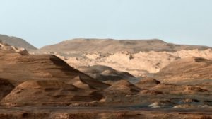
“This composite, false-color image of Mount Sharp inside Gale crater on Mars shows geologists a changing planetary environment. On Mars, the sky is not blue, but the image was made to resemble Earth so that scientists could distinguish stratification layers. NASA/JPL/Provided” (Cornell Chronicle)

The full text of the excellent paper is available:

[…]

“We identified megafloods for the first time using detailed sedimentological data observed by the rover Curiosity,” said co-author Alberto G. Fairén, a visiting astrobiologist in the College of Arts and Sciences. “Deposits left behind by megafloods had not been previously identified with orbiter data.”

[…]

The most likely cause of the Mars flooding was the melting of ice from heat generated by a large impact, which released carbon dioxide and methane from the planet’s frozen reservoirs. The water vapor and release of gases combined to produce a short period of warm and wet conditions on the red planet.

[…]

The Curiosity rover science team has already established that Gale Crater once had persistent lakes and streams in the ancient past. These long-lived bodies of water are good indicators that the crater, as well as Mount Sharp within it, were capable of supporting microbial life.

“Early Mars was an extremely active planet from a geological point of view,” Fairén said. “The planet had the conditions needed to support the presence of liquid water on the surface – and on Earth, where there’s water, there’s life.

“So early Mars was a habitable planet,” he said. “Was it inhabited? That’s a question that the next rover Perseverance … will help to answer.”

Perseverance, which launched from Cape Canaveral on July 30, is scheduled to reach Mars on Feb. 18, 2021.

[…]

East African Rift System is slowly breaking away, with Madagascar splitting into pieces

by Virginia Tech, Nov 13, 2020 in ScienceDaily


The African continent is slowly separating into several large and small tectonic blocks along the diverging East African Rift System, continuing to Madagascar — the long island just off the coast of Southeast Africa — that itself will also break apart into smaller islands.

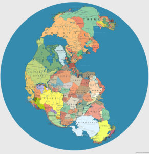
These developments will redefine Africa and the Indian Ocean. The finding comes in a new study by D. Sarah Stamps of the Department of Geosciences for the journal Geology. The breakup is a continuation of the shattering of the supercontinent Pangea some 200 million years ago.

Rest assured, though, this isn’t happening anytime soon.

“The rate of present-day break-up is millimeters per year, so it will be millions of years before new oceans start to form,” said Stamps, an assistant professor in the Virginia Tech College of Science. “The rate of extension is fastest in the north, so we’ll see new oceans forming there first.”

Geologists solve puzzle that could predict valuable rare earth element deposits

by University of Exter, Oct. 11, 2020 in WUWT


Pioneering new research has helped geologists solve a long-standing puzzle that could help pinpoint new, untapped concentrations of some the most valuable rare earth deposits.

A team of geologists, led by Professor Frances Wall from the Camborne School of Mines, have discovered a new hypothesis to predict where rare earth elements neodymium and dysprosium could be found.

The elements are among the most sought after, because they are an essential part of digital and clean energy manufacturing, including magnets in large wind turbines and electric cars motors.

For the new research, scientists conducted a series of experiments that showed sodium and potassium – rather than chlorine or fluorine as previously thought – were the key ingredients for making these rare earth elements soluble.

This is crucial as it determines whether they crystalise – making them fit for extraction – or stayed dissolved in fluids.

The experiments could therefore allow geologists to make better predictions about where the best concentrations of neodymium and dysprosium are likely to be found.

The results are published in the journal, Science Advances on Friday, October 9th 2020.

University of Exeter researchers, through the ‘SoS RARE’ project, have previously studied many natural examples of the roots of very unusual extinct carbonatite volcanoes, where the world’s best rare earth deposits occur, in order to try and identify potential deposits of the rare earth minerals.

Curved rock etchings reveal which way dangerous faults ruptured—and how they might again

by P. Voosen, Sep 23, 2020 in AAAS Science


Many of the world’s most dangerous earthquake faults are a silent menace: They have not ruptured in more than a century. To gauge the hazard they pose to buildings and people, geologists cannot rely on the record of recent strikes, captured by seismometers. Instead, they must figure out how the faults behaved in the past by looking for clues in the rocks themselves, including slickenlines, scour marks along the exposed rock face of a fault that can indicate how much it slipped in past earthquakes.

Earthquakes don’t happen all at once. Rather, the slip between rocks begins at one spot on the face of the fault—the hypocenter—and travels along it, like a zipper being unzipped. As the rupture advances, the earthquake waves it generates pile up and intensify, like the siren of an approaching ambulance. Los Angeles lies at the northern terminus of the southern San Andreas fault, Ampuero notes. “If it breaks north, toward LA, that would be pretty bad.”

Life on Earth may have begun in hostile hot springs

by Jack L. Lee, Sep 245, 2020 in Sciencenews


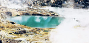
At Bumpass Hell in California’s Lassen Volcanic National Park, the ground is literally boiling, and the aroma of rotten eggs fills the air. Gas bubbles rise through puddles of mud, producing goopy popping sounds. Jets of scorching-hot steam blast from vents in the earth. The fearsome site was named for the cowboy Kendall Bumpass, who in 1865 got too close and stepped through the thin crust. Boiling, acidic water burned his leg so badly that it had to be amputated.

Some scientists contend that life on our planet arose in such seemingly inhospitable conditions. Long before creatures roamed the Earth, hot springs like Bumpass Hell may have promoted chemical reactions that linked together simple molecules in a first step toward complexity. Other scientists, however, place the starting point for Earth’s life underwater, at the deep hydrothermal vents where heated, mineral-rich water billows from cracks in the ocean floor.

As researchers study and debate where and how life on Earth first ignited, their findings offer an important bonus. Understanding the origins of life on this planet could offer hints about where to search for life elsewhere, says Natalie Batalha, an astrophysicist at the University of California, Santa Cruz. “It has very significant implications for the future of space exploration.” Chemist Wenonah Vercoutere agrees. “The rules of physics are the same throughout the whole universe,” says Vercoutere, of NASA’s Ames Research Center in Moffett Field, Calif. “So what is there to say that the rules of biology do not also carry through and are in place and active in the whole universe?”

Meteorite study suggests Earth may have been wet since it formed

by Washington University in St. Louis, Aug 27, 2020 in ScienceDaily


Enstatite chondrite meteorites, once considered ‘dry,’ contain enough water to fill the oceans — and then some

A new study finds that Earth’s water may have come from materials that were present in the inner solar system at the time the planet formed — instead of far-reaching comets or asteroids delivering such water. The findings published Aug. 28 in Science suggest that Earth may have always been wet.

Researchers from the Centre de Recherches Petrographiques et Geochimiques (CRPG, CNRS/Universite de Lorraine) in Nancy, France, including one who is now a postdoctoral fellow at Washington University in St. Louis, determined that a type of meteorite called an enstatite chondrite contains sufficient hydrogen to deliver at least three times the amount of water contained in the Earth’s oceans, and probably much more.

Enstatite chondrites are entirely composed of material from the inner solar system — essentially the same stuff that made up the Earth originally.

“Our discovery shows that the Earth’s building blocks might have significantly contributed to the Earth’s water,” said lead author Laurette Piani, a researcher at CPRG. “Hydrogen-bearing material was present in the inner solar system at the time of the rocky planet formation, even though the temperatures were too high for water to condense.”

Le Précambrien : les bactéries, la tectonique des plaques et l’oxygène

by A. Préat (.pdf), 21 août 2020 in Bull.Séanc.Acad.R.Sci.OutreMer


 Mots-clés. — Écosystèmes microbiens; Isotopes du carbone et du soufre; Oxydoréduction; Oxygène; Océans et atmosphère. 

Résumé. — L’oxygène n’est pas apparu aussi brutalement qu’on le pensait sur notre planète. Malgré un apport en oxygène lié aux cyanobactéries dès l’archéen, ce ne sont pas ces microorganismes qui sont à la base de la première grande «révolution» de l’oxygène qui a eu lieu à la limite archéen/paléoprotérozoïque (il y a deux milliards et demi d’années) dans l’atmosphère, lors du Grand Événement d’Oxydation. Ce sont les processus liés au cycle de la tectonique des plaques (activité mantellique et périodes intenses d’érosion/altération) qui ont contribué de manière déterminante à l’augmentation de la concentration de l’oxygène atmosphérique voici deux milliards et demi d’années. Les deux principaux processus responsables de cette augmentation sont liés à l’enfouissement de la matière organique et de la pyrite. L’altération des séries riches de ces deux composants conditionnera ensuite pendant près d’un milliard d’années la composition chimique des océans en oxygène, soufre et fer. Au cours du temps, l’oxygène proviendra de l’activité des cyanobactéries et l’atmosphère réductrice du début de l’archéen sera remplacée par une atmosphère oxydante à la fin du précambrien. 

Keywords. — Microbial Ecosystems; Carbon and Sulfur Isotopes; Oxidation Reduction; Oxygen; Oceans and Atmosphere. 

Summary. — The Precambrian: Bacteria, Plate Tectonics and Oxygen. — Oxygen did not appear as abruptly as we thought on our planet. Despite an oxygen supply related to cyanobacteria since the Archean, these microorganisms are not at the origin of the first great oxygen revolution that took place at the Archean/Paleoproterozoic boundary (two and a half billion years) in the atmosphere during the Great Oxidation Event. Two processes related to the cycle of plate tectonics (mantle activity and intense periods of erosion/weathering) were mostly involved in the increase of the atmospheric oxygen concentration two and a half billion years ago. These two main processes are related to the burial of organic matter and pyrite. The alteration of series with high contents of these two elements will then condition for nearly one billion years the oxygen, sulfur and iron chemical composition of the oceans. Oxygen will finally come from the activity of cyanobacteria and the early Archean reducing atmosphere will be replaced by an oxidizing atmosphere at the end of the Precambrian. 

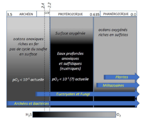
Fig. 3. — Évolution des compositions chimiques et des organismes des océans en trois phases majeures. À l’archéen, les océans contiennent peu d’oxygène et sont relativement riches en fer (colonne de gauche), alors que dans les océans modernes (colonne de droite) l’oxygène est abondant et le fer en quantité limitée. Entre ces deux phases, un long intervalle d’un peu plus d’un milliard d’années est caractérisé par des océans avec des concentrations modérées d’oxygène en surface et des eaux plus profondes riches en H2S en présence de quantités limitées de fer, de molybdène et d’autres éléments en traces importants dans les cycles biologiques. La colonne centrale représente l’«Océan de Canfield» et caractérise le Boring Billion. L’H2S produit (suite à la présence des sulfates, cf. texte) réagit avec le fer ferreux pour former la pyrite. Le fer ferreux n’est donc pas consommé par l’oxygène durant cet intervalle de temps, mais par l’H2S. L’Événement Lomagundi-Jatuli a lieu à environ 2,1 Ga dans le GOE (Great Oxidation Event), marqué par une très forte production d’oxygène. Le début du GOE est marqué par l’oxydation de la pyrite sur les cratons et la disparition des minéraux détritiques sensibles aux conditions d’oxydoréduction des éléments chalcophiles ou sidérophiles (uraninite, sidérite, pyrite, molybdénite, etc.). Les deux grands épisodes «Terre Boule de Neige» à 2,3 Ga («Glaciation Makganyena») et 0,635 («Glaciation Marinoenne»), et d’autres événements glaciaires moins importants ne sont pas reportés ni discutés dans le texte (modifié d’après Knoll 2003). 


World’s Largest Meteorite

by Geology Page, January 8, 2017


Name: Hoba “This is an OFFICIAL meteorite name”
Abbreviation: There is no official abbreviation for this meteorite.
Observed fall: No
Year found: 1920
Country: Namibia
Mass: 60 tons

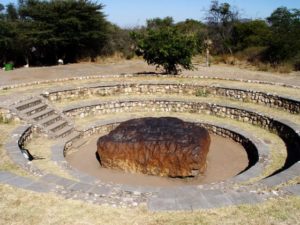
The Hoba or Hoba West meteorite lies on the farm “Hoba West”, not far from Grootfontein, in the Otjozondjupa Region of Namibia. It has been uncovered but, because of its large mass, has never been moved from where it fell. The main mass is estimated at more than 60 tons, making it the largest known meteorite (as a single piece) and the most massive naturally occurring piece of iron known on Earth’s surface.

Impact

The Hoba meteorite impact is thought to have occurred more recently than 80,000 years ago. It is inferred that the Earth’s atmosphere slowed the object to the point that it impacted the surface at terminal velocity, thereby remaining intact and causing little excavation.

Assuming a drag coefficient of about 1.3, the meteor would have been slowed to about 720 miles per hour (0.32 km/s) from its speed on entering the Earth’s atmosphere, typically in excess of 10 km/s for similar objects. The meteorite is unusual in that it is flat on both major surfaces, possibly causing it to have skipped across the top of the atmosphere like a flat stone skipping on water.

Read more : http://www.geologypage.com/2017/01/worlds-largest-meteorite.html#ixzz6U2Q7UUR8
Follow us: @geologypage on Twitter | geologypage on Facebook

Evolution after Chicxulub asteroid impact: Rapid response of life to end-cretaceous mass

by Geological Society of America, July 14, 2020 in ScienceDaily


The impact event that formed the Chicxulub crater (Yucatán Peninsula, México) caused the extinction of 75% of species on Earth 66 million years ago, including non-avian dinosaurs. One place that did not experience much extinction was the deep, as organisms living in the abyss made it through the mass extinction event with just some changes to community structure.

New evidence from International Ocean Discovery Program (IODP) Expedition 364 of trace fossils of burrowing organisms that lived in the seafloor of the Chicxulub Crater beginning a few years after the impact shows just how quick the recovery of the seafloor ecosystem was, with the establishment of a well-developed tiered community within  approximately 700,000 years after the event.

Impact-induced amino acid formation on Hadean Earth and Noachian Mars

by Takeuchi et al., June8, 2020 in SciReports Open Access


Abstract

Abiotic synthesis of biomolecules is an essential step for the chemical origin of life. Many attempts have succeeded in synthesizing biomolecules, including amino acids and nucleobases (e.g., via spark discharge, impact shock, and hydrothermal heating), from reduced compounds that may have been limited in their availabilities on Hadean Earth and Noachian Mars. On the other hand, formation of amino-acids and nucleobases from CO2 and N2 (i.e., the most abundant C and N sources on Earth during the Hadean) has been limited via spark discharge. Here, we demonstrate the synthesis of amino acids by laboratory impact-induced reactions among simple inorganic mixtures: Fe, Ni, Mg2SiO4, H2O, CO2, and N2, by coupling the reduction of CO2, N2, and H2O with the oxidation of metallic Fe and Ni. These chemical processes simulated the possible reactions at impacts of Fe-bearing meteorites/asteroids on oceans with a CO2 and N2 atmosphere. The results indicate that hypervelocity impact was a source of amino acids on the Earth during the Hadean and potentially on Mars during the Noachian. Amino acids formed during such events could more readily polymerize in the next step of the chemical evolution, as impact events locally form amino acids at the impact sites.

Asteroid, climate change not responsible for mass extinction 215 million years ago

by Todd McLeish, May 27, 2020 U. of RhodeIsland in PhysOrg


A team of University of Rhode Island scientists and statisticians conducted a sophisticated quantitative analysis of a mass extinction that occurred 215 million years ago and found that the cause of the extinction was not an asteroid or climate change, as had previously been believed. Instead, the scientists concluded that the extinction did not occur suddenly or simultaneously, suggesting that the disappearance of a wide variety of species was not linked to any single catastrophic event.

Their research, based on paleontological field work carried out in sediments 227 to 205 million years old in Petrified Forest National Park, Arizona, was published in April in the journal Geology.

..

Giant tectonic plate under Indian Ocean is breaking in two

by Geggel L., May 21, 2020 in LiveScience


The giant tectonic plate under the Indian Ocean is going through a rocky breakup … with itself.

In a short time (geologically speaking) this plate will split in two, a new study finds.

To humans, however, this breakup will take an eternity. The plate, known as the India-Australia-Capricorn tectonic plate, is splitting at a snail’s pace — about 0.06 inches (1.7 millimeters) a year. Put another way, in 1 million years, the plate’s two pieces will be about 1 mile (1.7 kilometers) farther apart than they are now.

“It’s not a structure that is moving fast, but it’s still significant compared to other planet boundaries,” said study co-researcher Aurélie Coudurier-Curveur, a senior research fellow of marine geosciences at the Institute of Earth Physics of Paris.

Related: In photos: Ocean hidden beneath Earth’s surface

For instance, the Dead Sea Fault in the Middle East is moving at about double that rate, or 0.2 inches (0.4 centimeters) a year, while the San Andreas Fault in California is moving about 10 times faster, at about 0.7 inches (1.8 cm) a year.

The plate is splitting so slowly and it’s so far underwater, researchers almost missed what they’re calling the “nascent plate boundary.” But two enormous clues — that is, two strong earthquakes originating in a strange spot in the Indian Ocean — suggested that Earth-changing forces were afoot.

On April 11, 2012, a magnitude-8.6 and magnitude-8.2 earthquake hit beneath the Indian Ocean, near Indonesia. The earthquakes didn’t happen along a subduction zone, where one tectonic plate slides under another. Instead, these quakes originated in a weird place for earthquakes to happen — in the middle of the plate.

Scientists “Discover” Largest Shield Volcano on Earth

by D. Middleton, May 15, 2020 in WUWT


And it’s not Mauna Loa…

UH researchers reveal largest and hottest shield volcano on Earth
Posted on May 13, 2020 by Marcie Grabowski

In a recently published study, researchers from the University of Hawai‘i at Mānoa School of Ocean and Earth Science and Technology revealed the largest and hottest shield volcano on Earth. A team of volcanologists and ocean explorers used several lines of evidence to determine Pūhāhonu, a volcano within the Papahānaumokuākea Marine National Monument, now holds this distinction.

Geoscientists and the public have long thought Mauna Loa, a culturally-significant and active shield volcano on the Big Island of Hawai‘i, was the largest volcano in the world. However, after surveying the ocean floor along the mostly submarine Hawaiian leeward volcano chain, chemically analyzing rocks in the UH Mānoa rock collection, and modeling the results of these studies, the research team came to a new conclusion. Pūhāhonu, meaning ‘turtle rising for breath’ in Hawaiian, is nearly twice as big as Mauna Loa.

“It has been proposed that hotspots that produce volcano chains like Hawai‘i undergo progressive cooling over 1-2 million years and then die,” said Michael Garcia, lead author of the study and retired professor of Earth Sciences at SOEST. “However, we have learned from this study that hotspots can undergo pulses of melt production. A small pulse created the Midway cluster of now extinct volcanoes and another, much bigger one created Pūhāhonu. This will rewrite the textbooks on how mantle plumes work.”

[…]

University of Hawai‘i at Mānoa School of Ocean and Earth Science and Technology

Are We Seeing a New Ocean Starting to Form in Africa?

by Klemetti, E., May 8, 2020 in EOS


Although shallow magma storage at Erta Ale volcano hints at a rift-to-ridge transition, the tectonic future of the Afar region is far from certain.

Standing next to a lava lake at the summit of a massive volcano, Christopher Moore, a Ph.D. candidate at the School of Earth and Environment at the University of Leeds in the United Kingdom, could see the red haze of lava flows a few kilometers away. This might seem like a rare sight, but at Ethiopia’s Erta Ale, it’s business as usual.

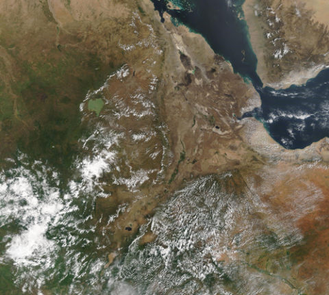
Are such behaviors the first signs of a tectonic transition? This question is part of what Moore has been studying at Erta Ale. The entire Afar region in eastern Africa finds itself in the middle of changes that could split the continent, forming a new ocean basin. The magmatism at Erta Ale might be offering signs of this switch by mimicking the characteristics of a mid-ocean ridge.

Satellite image of eastern Africa, with the Red Sea and the Gulf of Aden to the east
The East African Rift valley, the Red Sea, and the Gulf of Aden are clearly visible in this Landsat 8 image, taken on 8 November 2019. Credit: NASA/Erik Klemetti

However, there isn’t agreement about how close the Afar region is to this tectonic transition. The geophysical characteristics of magma storage at Erta Ale could point to the region’s conversion to an incipient oceanic spreading center, but the petrology of the erupting lava might be telling us that we aren’t there yet.

Did heavy rains trigger the eruption of the most dangerous U.S. volcano? Scientists are skeptical

by  RP Ortega, April 22, 2020 in ScienceAAAS


In May 2018, Hawaii’s Kilauea volcano let loose its largest eruption in 200 years, spewing plumes of ash high into the air, and covering hundreds of homes in lava. The eruption terrified local residents, but it gave scientists a once-in-a-lifetime opportunity to study the volcano’s explosive behavior. Now, a new study claims that extreme rainfall boosted underground pressures and was the “dominant factor” in triggering the eruption.

It’s not the first time rainfall has been linked to volcanic activity, says Jenni Barclay, a volcanologist at the University of East Anglia who was not involved in the new work. Previous research suggests storms passing over Mount St. Helens may have played a role in explosive activity between 1989 and 1991. And intense rains fell shortly before and during the activity of Montserrat’s Soufrière Hills volcano from 2001 to 2003. Rain may have also triggered eruptions of Réunion’s Piton de la Fournaise volcano. Still, Barclay believes rain is, at best, a contributing factor to volcanic eruptions and not the main driver. “It’s a series of coincident events that have led to the triggering of this larger episode,” she says.

Researchers on the new study used satellite data from NASA and Japan’s space agency to estimate rainfall during the first months of 2018, before the start of the eruption. More than 2.25 meters of rain fell on the volcano in the first months of 2018, the researchers found. They created a model to show how the accumulated rainfall could seep into the pore spaces in rocks deep underground, boosting pressures that eventually caused fissures in the volcano’s flank to open up and release magma. When they looked at records of previous Kilauea eruptions going back to 1790, they found that 35—more than half—started during the nearly 6-month rainy season.

Lunar Recession and the Age of the Earth: How Uniformitarianism Works

by D. Middleton, March 24, 2020 in WUWT


One of the things I love about writing for Watts Up With That, is the fact that reader comments often inspire me to research and write subsequent posts. In my recent post about the origins of the Moon, one commentator suggested that the rate of lunar recession (tidal acceleration) indicated that the Earth was much younger than 4.5 billion years old and/or somehow disproved the geological Principle of Uniformitarianism. I didn’t give much thought to my reply. I simply calculated the distance from the Earth to the Moon 1 billion and 4.5 billion years ago. The Moon is currently receding (moving away) from the Earth at a rate of about 3.8 cm/yr. This has been directly measured with lasers.

At 3.8 cm/yr, the Moon would have been 215,288 miles away from Earth a billion years ago. It is currently an average of 238,900 miles away. At 3.8 cm/yr, it still would have been 132,646 miles away 4.5 BY.

If the Moon did did originate from a collision with Earth, it would have been a lot closer to Earth 4.5 BY than 100,000 miles.