by C. Morrison, Feb 8,2025 in TheDailySceptic
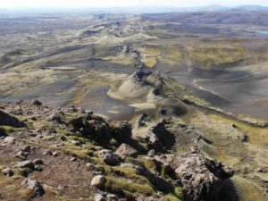
In January 2022, a massive underwater volcano called Hunga Tonga suddenly erupted and shot so much water into the upper atmosphere that levels in the stratosphere rose suddenly by at least 10%. It was a genuine one in 100, even 200 year event and was reasonably expected to produce temporary weather changes around the globe. Sure enough, subsequent temperatures showed a 0.3-0.4°C upward spike. Needless to say, the Net Zero fanatics claimed the rise as their own and blamed it on humans controlling the climate by increasing the trace gas carbon dioxide. Today the Daily Sceptic can give wider publicity to sensational recent findings that suggest Hunga Tonga was the main culprit in producing the recent spike. The scientists directly link a dramatic cooling in the upper atmosphere of between 0.5-2°C to Hunga Tonga. It is generally held that there is an anti-correlation between the lower and upper atmosphere and cooling at the top produces warming at the bottom due to a number of complex atmospheric processes.
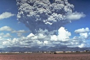
Hunga Tonga was an unusual volcanic eruption since it produced few dust particulates that usually cool the surface. Two recent land-based eruptions, El Chichon and Pinatubo, caused a temporary downward spike of around 0.5°C. The team of Colorado-based scientists found that the Hunga Tonga cooling was “comparable in magnitude” to the stratospheric warming caused by the two surface volcanoes in 1982 and 1991. The scientists reported “good agreement of observations with chemistry-climate model simulations”. “Cooling is mainly due to Hunga Tonga H2O [water] impacts,” they state.
This is dramatic stuff. It appears to promote Hunga Tonga as the prime cause in explaining the recent spike in temperatures. Indeed it could be concluded that the temperature rise should have been a little higher – and higher even still if the effects of a recent strong El Niño natural oscillation are included. Satellite observations, confirmed by computer analysis, shows stratospheric cooling of 0.5°C to 1°C in the middle and upper stratosphere during 2022 through middle 2023, followed by stronger reductions of 1°C to 2°C in the mesosphere after the middle of 2023, note the scientists. Last year, two distinguished atmospheric scientists observed the anti-correlation between the higher and lower atmosphere and suggested the lower stratosphere cooled by approximately two degrees per degree of warming nearer the surface. Where the troposphere has been anomalously warming, the lower stratosphere has been anomalously cooling “and vice versa”, note the scientists.
In January 2022, a massive underwater volcano called Hunga Tonga suddenly erupted and shot so much water into the upper atmosphere that levels in the stratosphere rose suddenly by at least 10%. It was a genuine one in 100, even 200 year event and was reasonably expected to produce temporary weather changes around the globe. Sure enough, subsequent temperatures showed a 0.3-0.4°C upward spike. Needless to say, the Net Zero fanatics claimed the rise as their own and blamed it on humans controlling the climate by increasing the trace gas carbon dioxide. Today the Daily Sceptic can give wider publicity to sensational recent findings that suggest Hunga Tonga was the main culprit in producing the recent spike. The scientists directly link a dramatic cooling in the upper atmosphere of between 0.5-2°C to Hunga Tonga. It is generally held that there is an anti-correlation between the lower and upper atmosphere and cooling at the top produces warming at the bottom due to a number of complex atmospheric processes.
Hunga Tonga was an unusual volcanic eruption since it produced few dust particulates that usually cool the surface. Two recent land-based eruptions, El Chichon and Pinatubo, caused a temporary downward spike of around 0.5°C. The team of Colorado-based scientists found that the Hunga Tonga cooling was “comparable in magnitude” to the stratospheric warming caused by the two surface volcanoes in 1982 and 1991. The scientists reported “good agreement of observations with chemistry-climate model simulations”. “Cooling is mainly due to Hunga Tonga H2O [water] impacts,” they state.
This is dramatic stuff. It appears to promote Hunga Tonga as the prime cause in explaining the recent spike in temperatures. Indeed it could be concluded that the temperature rise should have been a little higher – and higher even still if the effects of a recent strong El Niño natural oscillation are included. Satellite observations, confirmed by computer analysis, shows stratospheric cooling of 0.5°C to 1°C in the middle and upper stratosphere during 2022 through middle 2023, followed by stronger reductions of 1°C to 2°C in the mesosphere after the middle of 2023, note the scientists. Last year, two distinguished atmospheric scientists observed the anti-correlation between the higher and lower atmosphere and suggested the lower stratosphere cooled by approximately two degrees per degree of warming nearer the surface. Where the troposphere has been anomalously warming, the lower stratosphere has been anomalously cooling “and vice versa”, note the scientists.
…