by R. Kurmeloys, Oct 29, 2025 in Science
Universities aren’t training the specialists needed to exploit the country’s rich resources
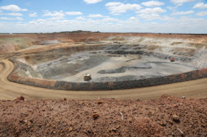
The Mount Holland lithium mine in Western Australia is just one of the nation’s roughly 350 mines.PHILIP GOSTELOW/BLOOMBERG VIA GETTY IMAGES
When the United States and Australia last week announced an $8.5 billion deal for the island continent to develop new supplies of critical minerals used in clean energy technologies and military hardware, many analysts focused on what the pact might mean for geopolitics and global trade. But some researchers raised concerns about a different resource: the geoscientists needed to find and extract the minerals. Even as demand for these specialists is growing, they say, Australia’s universities are having difficulty attracting earth science students and are shuttering programs.
The government wants to reverse the trend, and last week’s deal sharpened the economic stakes. “If you can’t find those resources to begin with, there ain’t nothing to sell,” says earth scientist David Cohen, former president of the Australian Geoscience Council.
Under the deal, Australia will supply raw and processed critical minerals, such as cobalt and nickel, to the U.S. as part of a broader effort to break China’s near-complete hold over that market. Australia already has some 350 mines and is the world’s largest producer of hard-rock lithium, a critical mineral used in current battery technology, and zirconium, used to make heat-resistant alloys.
But an ongoing slump in Australia’s geoscience training efforts could hamper the search for new deposits. Over the past 15 years, Cohen notes, the number of Australian universities awarding geoscience degrees recognized by professional accreditation bodies has dropped from 21 to 13. Macquarie University and the universities of Wollongong and Newcastle have recently closed their earth science departments or merged them with others, and there’s growing concern about the program at the Queensland University of Technology, notes geologist Hugo Olierook of Curtin University. At Australian National University, recruitment struggles and other issues have meant that “if you adjust for inflation, our budget is 50% of what it was in 2020,” says computational and observational geodynamicist Rhodri Davies.
“The future for home-grown talent is bleak,” Olierook told Australia’s Science Media Centre after last week’s deal.
Researchers say the decline threatens Australia’s scientific capability to address a wide range of issues beyond mining, including climate change, water quality and supply, and energy development. And unless the trends change, the nation will face a “capability gap” in the geosciences by 2035, found a report released in September by the Australian Academy of Science. Other countries around the world are experiencing similar declines, meaning Australia likely can’t solve the problem simply by importing talent, says Cohen, who also serves as treasurer of the International Union of Geological Sciences.
…,