Archives par mot-clé : Storms

UK Met Office Fails to Retract False Claim of “More Intense” Storms Due to Climate Change

by C. Morrison, Feb 23, 2023 in WUWT


The Met Office is refusing to retract a claim made by a senior meteorologist on BBC Radio 5 Live that storms in the U.K. are becoming “more intense” due to climate change. This is despite admitting in Freedom of Information (FOI) documents that it had no evidence to back up the claim. The Global Warming Policy Foundation (GWPF) noted the “false” claim seriously misled the public and demanded a retraction. The Daily Sceptic covered the story last Thursday and has since contacted the Met Office on three occasions seeking a response. “False information of this kind does much to induce climate anxiety in the population and I am sure you would agree such errors should be corrected by any reputable organisation,” it was noted. No reply was received – no retraction has been forthcoming.

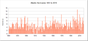
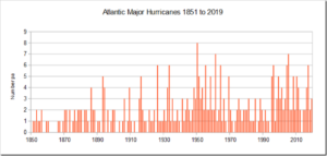
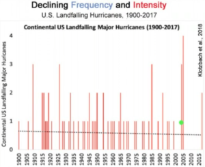
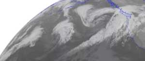
The storm claim was made by Met Office spokesman Clare Nasir on January 22nd and led to an FOI request for an explanation by the investigative journalist Paul Homewood. The Met Office replied that it was unable to answer the request due to the fact that the information “is not held”. Interestingly, the Met Office’s own 2022 climate report noted that the last two decades have seen fewer occurrences of maximum wind speeds in the 40, 50, 60 knot bands than previous decades. The Daily Sceptic report went viral on social media with almost 3,000 retweets on X, while GWPF’s demand for retraction was covered by the Scottish Daily Express.

The lack of action by the state-funded Met Office is very interesting. Extreme weather is now the major go-to explanation for the opinion that humans largely control the climate, despite a general lack of scientific evidence. Backing away from this ‘settled’ narrative risks damaging a potent tool nudging populations across the world towards the collectivist Net Zero political project. Mainstream media usually take care to fudge their reporting of any direct link, using phrases such as ‘scientists say’ and sprinkling words ‘could’ and ‘might’ in the copy. The mistake Nasir made was to forget this basic requirement of broadcast fearmongering.

There appears to be an arrogance around the Met Office, an arrogance it shares with many other organisations and scientists promoting Net Zero …

….

Calls for Met Office to retract false ‘more intense storms’ claim

by GWPF, Feb 13, 2024


London, 13 February – The UK Met Office has been accused of seriously misleading the public about climate-driven storms in the UK.

On 22nd January, the day after Storm Isha, a senior meteorologist from the Met Office stated on BBC Radio 5 Live Breakfast that “when we see these storms they are more intense and that’s down to climate change”.

However, after being challenged through a FOI request to provide evidence for the claim that storms have become more intense, the Met Office was forced to admit they have no such evidence.

In its response, the Met Office also referred to its own UK Storm activity report which clearly states that “there is no compelling trend in maximum gust speeds recorded in the UK since 1969.”

We call on the Met Office to publish a full retraction of what is evidently a false and misleading claim.

NOTES FOR EDITORS

Met Office: Recent trends and future projections of UK storm activity: “This report found that there is no compelling trend in maximum gust speeds recorded in the UK since 1969, measured as the number of days more than 20 weather stations recorded gust speeds above 40, 50 or 60 knots.”

Met Office: State of the UK Climate 2022 (page 47):  “Storm Eunice [in 2022] was the most severe storm to affect England and Wales since February 2014, but even so, these storms of the 1980s and 1990s were very much more severe.”

Paul Homewood: Met Office cannot provide evidence for “more intense storms” claim

Critical Examination of Hurricane Intensification Predictions

by J. Steele, Oct 1, 2023 in WUWT


Why climate models not yet worth their salt!

As all hurricane researchers lament, model predictions of when and where hurricanes will intensify, have not improved much in the past 20 years. As recently as the early 2010s, weather model forecasts failed to predict 88 percent of rapidly intensifying tropical storms. Nonetheless National Public Radio (NPR) has ranted that hurricanes are “intensifying more quickly, turning from less-serious storms to very strong ones in hours or days. Superheated ocean waters hold a lot of extra energy, and a growing storm can draw from that enormous pool.” But such “superheated water” is not widespread as rising CO2 narratives suggest, but found only in very limited regions and usually associated with “barrier layers”.

Hurricanes intensify as they draw “superheated” subsurface waters  of 65.5°F or higher. However, when a hurricane’s suction pulls up cooler subsurface waters, the hurricane weakens. This negative feedback naturally limits the intensity of all hurricanes. In the upper panel of the attached graphic, Arnand (2023) illustrates where thin barrier layer exists, hurricane intensity hovers around Category 1. In contrast, where thick barrier layers form, cooler deep waters are prevented from reaching the surface, and instead allow superheated sub-surface waters to cause rapid intensification.

Denser fluids don’t naturally rise above less dense fluids! Barrier layer formation happens wherever freshwater overlays dense salty waters. Although solar heating would normally make subsurface waters less dense and rise to the surface, layers with higher saltiness makes the water more dense which inhibits warm convection. That traps and intensifies the subsurface heat, enabling hurricanes to intensify to Category 5.

Pacific Typhoons Defy Climate Experts’ Dire Forecasts…Trending Downward 70 Years!

by P. Gosselin, Aug 6, 2022 in NoTricksZone


Pacific typhoons have been trending downward for 70 years 

The Japan Meteorological Agency (JMA) presents the latest data for Pacific typhoons — going back to 1951.

This summer climate alarmists in Europe have been chasing “heat waves”, likely because hurricanes and typhoons have been on the quiet side.

Today we look at the data from the Japan Meteorological Agency (JMA) for the number of typhoons formed in the Pacific in the month of July, now that the July data are available:


Clearly the world has warmed somewhat since 1951, but contrary to what the climate bedwetters claim, the trend in typhoons has been downward – suggesting that a warmer climate leads to less Pacific storms in terms of typhoons formed. This is the opposite of what climate “experts” said would happen.

Next we look at the number of typhoons formed in the Pacific from January to July, going back to 1951:


Little evidence of changes in extreme weather trends

by P. Homewood, July 27, 2022 in NotaLotofPeopleKnowThat


New IPCC attribution statistics are distorting observational evidence

London, 27 July – A new paper from the Global Warming Policy Foundation finds that the IPCC’s recent shift in methodology has led to misleading claims about changes in weather extremes.

The review, from physicist Dr Ralph Alexander, finds that IPCC claims that many of these weather extremes are increasing significantly are largely unsupported by observational evidence.

Ralph Alexander: Extreme Weather: The IPCC’s Changing Tune (pdf)

According to Dr Alexander:
“On almost every kind of extreme weather, with the possible exemption of heatwaves, the evidence for significant changes is scant. But the latest IPCC report has introduced novel ‘attribution’ statistics and now insists that things are getting worse. It’s yet another case of scientists trying to scare the public into compliance.”

Dr Alexander’s paper looks at:
– droughts
– floods
– hurricanes
– tornadoes
– wildfires
– hot and cold extremes
– coral bleaching.

He concludes that:
“The mistaken belief that weather extremes are worsening because of climate change is more a perception, fostered by media coverage, than reality. The IPCC’s new statistical method is playing an unworthy part in bringing this sorry state of affairs to pass.”

GWPF invited the Royal Society and the Met Office to review this paper, and to submit a response to be published as an appendix to it. No reply was received.

Predicting Atlantic Hurricanes Using Machine Learning

by V. Herrera et al., Apr 2002, in AtmosphereMPDI


Every year, tropical hurricanes affect North and Central American wildlife and people. The ability to forecast hurricanes is essential in order to minimize the risks and vulnerabilities in North and Central America. Machine learning is a newly tool that has been applied to make predictions about different phenomena. We present an original framework utilizing Machine Learning with the purpose of developing models that give insights into the complex relationship between the land–atmosphere–ocean system and tropical hurricanes. We study the activity variations in each Atlantic hurricane category as tabulated and classified by NOAA from 1950 to 2021. By applying wavelet analysis, we find that category 2–4 hurricanes formed during the positive phase of the quasi-quinquennial oscillation. In addition, our wavelet analyses show that super Atlantic hurricanes of category 5 strength were formed only during the positive phase of the decadal oscillation. The patterns obtained for each Atlantic hurricane category, clustered historical hurricane records in high and null tropical hurricane activity seasons. Using the observational patterns obtained by wavelet analysis, we created a long-term probabilistic Bayesian Machine Learning forecast for each of the Atlantic hurricane categories. Our results imply that if all such natural activity patterns and the tendencies for Atlantic hurricanes continue and persist, the next groups of hurricanes over the Atlantic basin will begin between 2023 ± 1 and 2025 ± 1, 2023 ± 1 and 2025 ± 1, 2025 ± 1 and 2028 ± 1, 2026 ± 2 and 2031 ± 3, for hurricane strength categories 2 to 5, respectively. Our results further point out that in the case of the super hurricanes of the Atlantic of category 5, they develop in five geographic areas with hot deep waters that are rather very well defined: (I) the east coast of the United States, (II) the Northeast of Mexico, (III) the Caribbean Sea, (IV) the Central American coast, and (V) the north of the Greater Antilles.

New Study Defies Alarmists, Finds “No Notable Changes” Between Present And Future Cyclone Energy

by P. Gosselin, July 10, 2021 in NoTricksZone


Good news: a warmer, likely tamer climate, is in the future recent science shows. A new study projects no  future increase in tropical storm energy.

Lots of government-funded climate scientists like claiming tropical cyclones are getting worse and that in the future we need to expect one supercharged storm after another – due to man heating the climate with carbon dioxide emissions.

But as we noted yesterday here, Zoe Phin found that hurricanes have not gone along with this dubious doomsday science over the past 25 years. Now a new study confirms things will continue that way.

Today German site Die kalte Sonne (DkS) presents its 49th video on climate and energy, featuring tropical storm energy.

Present vs future scenario

In the segment, DkS cites a new study appearing in the Geophysical Research Letters, where a team of scientists led by Philip Kreussler used three different global climate models to investigate tropical cyclone integrated kinetic energy which is closely associated with their damage potential.

No notable changes

CO2 Cyclone Doomsday Flat Out Refuted: 170 Years “Absolutely No Trend” In Hurricane Intensity/Frequency

by P. Gosselin, May, 22, 2021 in NoTricksZone


The latest comes from statistics expert, Zoe Phin, who looks at the alarmists’ claim that increasing CO2 emissions are leading to more frequent and intense Atlantic hurricanes.

Alarmist claims cost nothing, and so easily made. Zoe Phin looks at whether the hurricane alarmist claim holds up.

Frequency

First Zoe looked at the (HURDAT2) data to find out if the first of the two claims (increasing frequency) is true. At first glance it would appear so.

But Zoe asks if the method of measuring the frequency really is sensible and if it maybe weren’t better to measure the amount of time the Atlantic spends in hurricane mode? To find out, Zoe plotted the hurricane hours data and the 10-year moving average:

Source: Zoe Phin.

….

New Study Casts Doubt On Controversial Theory Linking Melting Arctic To Severe Winter Weather

by P. Voosen, May 13, 2021 in ClimagteChangeDispatch


Every time severe winter weather strikes the United States or Europe, reporters are fond of saying that global warming may be to blame.

The paradox goes like this: As Arctic sea ice melts and the polar atmosphere warms, the swirling winds that confine cold Arctic air weaken, letting it spill farther south.

But this idea, popularized a decade ago [and was the outlandish plotline in The Day After Tomorrow, pictured], has long faced skepticism from many atmospheric scientists, who found the proposed linkage unconvincing and saw little evidence of it in simulations of the climate.

Now, the most comprehensive modeling investigation into this link has delivered the heaviest blow yet: Even after the massive sea ice loss expected by midcentury, the polar jet stream will only weaken by tiny amounts—at most only 10% of its natural swings.

And in today’s world, the influence of ice loss on winter weather is negligible, says James Screen, a climate scientist at the University of Exeter and co-leader of the investigation, which presented its results last monthat the annual meeting of the European Geosciences Union.

Texas winter storm leaves 2M without power amid frigid temperatures

by E. Fordham, Feb 15, 2021 in FoxNews


HISTORIC WINTER STORM SLAMS TEXAS WITH RECORD COLD, ICY ROADS

Rotating power outages were initiated by the Electric Reliability Council of Texas, or ERCOT, early Monday morning, meaning thousands went without electricity for periods of time as temperatures fell into the teens near Dallas and 20s (about minus 5 degrees Celsius) around Houston.

Austin’s electric utility Austin Energy told residents the outages may be longer than usual, prompting angry social media replies from Texans who said they’d been without power for five or more hours.

“Typical events allow short durations of each outage, but outages are longer if the ERCOT grid requires — which is what we’re seeing in today’s event,” Austin Energy wrote on Twitter.

The utility advised residents to keep their keep their thermostat set to 68 degrees or lower, and to avoid using their oven or washing machine. Businesses were likewise advised to minimize operations to conserve energy.

See also : This Blizzard Exposes The Perils Of Attempting To ‘Electrify Everything’

AT LEAST 13 DEAD, HUNDREDS HOSPITALIZED AS RECORD SNOWSTORMS SWEEP JAPAN

by Cap Allon, Jan 23, 2021 in Electroverse


Following the historic snowstorms of the past few weeks, Japan has been hit again: at least 13 people died and more than 250 were injured as record snowfall blanketed regions along the Sea of Japan coast, according to the latest report by the nation’s Disaster Management Agency.

Among those to have lost their lives were three people in Fukui Prefecture, and four in Niigata Prefecture, all reportedly while trying to remove the snow which topped a whopping 3.13 meters (10.3 feet) in some areas.

According to Japan’s Meteorological Agency (JMA), at least 10 monitoring stations along the Sea of Japan set new all-time 72-hour snowfall records late on Jan. 10, and many more busted all-time low temperature records, including in Furue, Kamigoori, and Kuzakai–with the latter logging a bone-chilling -24C (-11F).


NYT: “What happened to Global Warming?”

by E. Worrall, Dec 17, 2020 in WUWT


NYT rolling out the tired global warming makes winter storms more extreme narrative.

How climate change is affecting winter storms.


By John Schwartz

The major winter storm that hit the Eastern United States on Wednesday and Thursday probably prompted some people to ask, “What happened to global warming?”

But although it’s becoming increasingly clear that climate change does have an effect on storms, the relationship can be complex and, yes, counterintuitive. “There were these expectations that winter was basically going to disappear on us,” said Judah Cohen, director of seasonal forecasting at AER, a company that provides information to clients about weather and climate-related risk.

Although winters are becoming warmer and somewhat milder over all, extreme weather events have also been on the increase, and especially in the Northeastern United States, as Dr. Cohen pointed out in a recent paper in the journal Nature Climate Change. From the winter of 2008-9 until 2017-18, there were 27 major Northeast winter storms, three to four times the totals for each of the previous five decades.

Read more: https://www.nytimes.com/2020/12/17/climate/climate-change-winter.html

If global warming to date has caused a three to four fold increase in severe winter storms, imagine the bitterly cold weather the next few decades of global warming will bring.

We must act now, before global warming causes us all to freeze to death!

First Time In 70 Years No Pacific Typhoon Forms In July… Alarmists Alarmed Typhoon Trend Falling!

by P. Gosselin, Ausgust 1, 2020 in NoTricksZone


This year is the first time since 1951 the Pacific sees no typhoons in the month of July. Typhoons have seen downward trend since 1951. 

Global warming alarmists like to claim that tropical storms will intensify and become more frequent unless people stop using fossil fuels.

And recently these alarmists have had our attention steered to the Atlantic basin, where tropical storms this year have seen quite an active season thus far.

Another reason the focus has been on the Atlantic is because very little has been happening in terms of Pacific typhoons, and the alarmists don’t want to talk about that.

In fact this July is the first July to have seen no typhoons formed in the Pacific at all since statistics on this began in 1951, according to the data from the Japan Meteorological Agency (JMA).

Data source: JMA, here and here

Normally between 3 to 4 typhoons form in the Pacific in July. Up to 8 have formed in the past, e.g. on 2017 and 1971. But this year July failed to see a single typhoon form – the first time this has occurred since 1951.

Storm Of The Century? Don’t Be Silly, Met Office

by P. Homewood, February 10, 2020 in NotaLotofPeopleKnowThat


Britain is facing further mayhem over the next 48 hours in the wake of Storm Ciara which battered Britain with winds of up to 100mph causing widespread flooding and travel chaos.

Hundreds of flights were grounded, motorways and main roads shut and trains cancelled and delayed in the wake of a storm that threatens further disruption.

The Met Office warned that ‘exceptional’ gusts of up to 70mph would strike again on Monday and issued snow and ice warnings for large swathes of northern England and almost all of Scotland. The south of England will also be hit for a second day by heavy winds.

Gusts of 97mph were recorded at the Needles off the Isle of Wight while Manchester Airport was buffeted by winds of up to 86mph.

Continuer la lecture de Storm Of The Century? Don’t Be Silly, Met Office

Despite 1990s Warming, Japan Climate Has Become More Agreeable, Less Extreme Over Past 100 Years!

by Kirye, January 9, 2020 in NoTricksZone


Though the media like to tell their audience that man-made climate change is leading to more extreme weather, the data don’t support it. In fact, one could easily argue that Japan’s climate is more agreeable today.

No trend in long-term annual precipitation

Over the past 100 years, for example, annual precipitation has not trended in an particular direction over the long term, showing rather some cyclical attributes:


Data source: Japan Meteorological Agency (JMA). 

If anything, precipitation has been rather steady for the better part of the past 2 decades, and even resembles what was observed about 60 years ago, in the 1950s.

Note how the extremes in precipitation occurred in the 1970s and 1980s when most of the climate talk was about global cooling. But overall, there’s been no trend change in precipitation in Japan.

Typhoons trending downward modestly!

The 2019 Atlantic Hurricane Season

by P. Homewood, December 11, 2019 in NotaLotofPeopleKnowThat


The Atlantic hurricane season has now officially ended, so let’s check the numbers.

https://www.aoml.noaa.gov/hrd/tcfaq/E11.html

http://rammb.cira.colostate.edu/products/tc_realtime/season.asp?storm_season=2019

There have been six hurricanes in total, including three major ones, Dorian, Humberto and Lorenzo. Coincidentally both numbers are the same as the average since 1950.

According to NOAA’s Hurricane Research Division, many hurricanes were missed in the earlier decades. Systematic aircraft reconnaissance began in 1944, but this only covered half of the Atlantic basin, until daily satellite monitoring started in 1966.

‘Alarmism Enforcement’ On Hurricanes And Global Warming

by J. Curry, Sep; 9, 2019 in ClimateChangeDispatch


I used to be concerned about ‘consensus enforcement’ on the topic of climate change.  Now I am concerned about ‘alarmism enforcement.’

Ever since Hurricane Katrina in 2005, any hurricane causing catastrophic damage has been seized upon by climate alarmists as evidence of the horrors of global warming.

As if the record-holding hurricanes from the 1920s through the 1950s never happened.

The catastrophic damage to the Bahamas from Hurricane Dorian is no different.  The ‘official’ statement from the alarmist contingent of climate scientists appears to be this article in the Guardian, by Mann and Dessler:

Unfortunately for the alarmists, there are several factors that are getting in the way of the public promotion of the Mann/Dessler narrative:

Alabama-gate:  President Trump’s insistence on defending his erroneous statements about the forecasts for Dorian impacting Alabama.  A good article summarizing all this was co-authored by one of my former students at Georgia Tech, Brandon Miller [link].

After the Alabama National Weather Service office made a statement that Alabama was not at risk from Dorian, NOAA issued a statement defending President Trump  [link].

A WaPo article describes this latest development [link], and the subsequent outrage among scientists and NOAA employees (past and present.

This whole situation is taking the oxygen out of the room in terms of discussions regarding Dorian and global warming.  Gotta wonder if this was the strategy?

Strong storms also play big role in Antarctic ice shelf collapse

by Oregon State University, July 18, 2019 in ScienceDaily


Warming temperatures and changes in ocean circulation and salinity are driving the breakup of ice sheets in Antarctica, but a new study suggests that intense storms may help push the system over the edge.

A research team led by U.S. and Korean scientists deployed three moorings with hydrophones attached seaward of the Nansen Ice Shelf in Antarctica’s Ross Sea in December of 2015, and were able to record hundreds of short-duration, broadband signals indicating the fracturing of the ice shelf.

The “icequakes” primarily took place between January and March of 2016, with the front of the ice sheet calving into two giant icebergs on April 7. The day the icebergs drifted away from the shelf coincided with the largest low-pressure storm system the region had recorded in the previous seven months, the researchers say.

Results of the study are being published this week in Frontiers in Earth Science.

Journal Reference:

  1. R. P. Dziak, W. S. Lee, J. H. Haxel, H. Matsumoto, G. Tepp, T.-K. Lau, L. Roche, S. Yun, C.-K. Lee, J. Lee, S.-T. Yoon. Hydroacoustic, Meteorologic and Seismic Observations of the 2016 Nansen Ice Shelf Calving Event and Iceberg Formation. Frontiers in Earth Science, 2019; 7 DOI: 10.3389/feart.2019.00183

Extremes

by Judith Curry, June14, 2019 in WUWT


Politics versus science in attributing extreme weather events to manmade global warming.

If you follow me on twitter, you may have noticed that I was scheduled to testify before the House Oversight and Reform Committee on Jun 12 [link].  The subject of the Hearing is Contending with Natural Disasters in the Wake of Climate Change.

Late on Jun 10, I received an email telling me that the Hearing is postponed (as yet unscheduled).  Apparently the Committee finds it more urgent to have a Hearing related to holding the Attorney General and Secretary of Commerce in contempt of Congress [link].  Interesting to ponder that Congressional procedural issues are deemed to be more important than Climate Change.

So I spent all last week working on my testimony (which is why there have been no new blog posts).  I hope the Hearing will eventually happen (Michael Mann is also scheduled to testify).

Hurricanes and climate change constitute a major portion of my testimony.  You may recall my recent series  on Hurricanes & climate change [link].  Specifically with regards to detection and attribution, my bottom line conclusion was:

“In summary, the trend signal in hurricane activity has not yet had time to rise above the background variability of natural processes. Manmade climate change may have caused changes in hurricane activity that are not yet detectable due to the small magnitude of these changes compared to estimated natural variability, or due to observational limitations. But at this point, there is no convincing evidence that manmade global warming has caused a change in hurricane activity.”

2019 Atlantic hurricane forecast

by J. Curry and J. Johnstone, June4, 2019 in ClimateEtc.


CFAN predicts an active North Atlantic hurricane season season.

The Atlantic hurricane has begun.  We are off to an early start with one wimpy subtropical storm that lasted less than a day, and a small system that is trying to spin up in the Bay of Campeche.

Other forecast providers have begun issuing forecasts:

  • NOAA predicts a near normal season with 4-8 hurricanes.
  • Tropical Storm Risk predicts slightly below normal activity, with 6 hurricanes and ACE of 88.
  • Colorado State University predicts near normal season:  6 hurricanes and ACE of 100

Climate Forecast Applications Network (CFAN) is going bold, see below. [link] to forecast report.

CFAN’s seasonal forecast

Table 1. Current (May) 2019 hurricane forecasts of North Atlantic ACE, North Atlantic total hurricanes, U.S. landfalling hurricanes. 

….

Roy Spencer: Why so many tornadoes this year? It’s not what AOC, Bernie Sanders (or maybe even you) think

by Charles the moderator, May 29, 2019 in WUWT


By Roy Spencer | Fox News

Progressive politicians like Al Gore, Sen. Bernie Sanders, I-Vt., and Rep. Alexandria Ocasio-Cortez, D.N.Y., don’t hesitate to blame any kind of severe weather – even if it is decreasing over time – on global warming.

With the devastating Dayton, Ohio tornadoes fresh on our minds, it is useful to examine exactly why (modest) global warming has produced fewer – not more – of such events.

The simple answer is that tornado formation requires unusually cool air.

Very few thunderstorms produce tornadoes. In the hot and humid tropics, they are virtually unheard of. The reason why is that (unlike hurricanes) tornadoes require strong wind shear, which means wind speed increasing and changing direction with height in the lower atmosphere.

These conditions exist only when a cool air mass collides with a warm air mass. And the perfect conditions for this have existed this year as winter has refused to lose its grip on the western United States. So far for the month of May 2019, the average temperature across the U.S. is close to 2 degrees Fahrenheit below normal.

40-Year Meteorologist Says Public “Being Fed Bill Of Goods” By Climate Alarmists On Hurricanes, Tornadoes

by P. Gosselin, April 14, 2019 in NoTricksZone


At the latest Saturday Summary at Weatherbell Analytics, Joe Bastardi, a well-known 40-year veteran of meteorology, looks at tornadoes and hurricanes.

Although many meteorologists and climatologists confirm that there is no data suggesting global warming is causing more frequent and intense tornado and hurricane activity, there is a small but influential alarmist group who claim otherwise. And it’s no surprise who the click-baiting media parrot at maximum volume.

Landfalling hurricanes downward trend

At the 5:45 mark, Joe presents a chart depicting the frequency of US landfalling hurricanes since 1900:


2019 Hurricane season forecast: below average

by Anthony Watts, April 4, 2019 in WUWT


Dr. Philip Klotzbach of Colorado State University writes on Twitter:

Seasonal #hurricane forecast from @ColoradoStateU predicts slightly below-average season: 13 named storms, 5 hurricanes & 2 major (Cat 3+, >=111 mph) hurricanes. Primary reason for slightly below-avg forecast is anticipated continuation of weak #ElNino.

We anticipate that the 2019 Atlantic basin hurricane season will have slightly belownormal activity. The current weak El Niño event appears likely to persist and perhaps even strengthen this summer/fall. Sea surface temperatures averaged across the tropical Atlantic are slightly below normal, and the far North Atlantic is anomalously cool.

Our Atlantic Multi-decadal Oscillation index is below its long-term average. We anticipate a slightly below-average probability for major hurricanes making landfall along the continental United States coastline and in the Caribbean. As is the case with all hurricane seasons, coastal residents are reminded that it only takes one hurricane making landfall to make it an active season for them. They should prepare the same for every season, regardless of how much activity is predicted.

PROBABILITIES FOR AT LEAST ONE MAJOR (CATEGORY 3-4-5) HURRICANE LANDFALL ON EACH OF THE FOLLOWING COASTAL AREAS:

1) Entire continental U.S. coastline – 48% (average for last century is 52%)

2) U.S. East Coast Including Peninsula Florida – 28% (average for last century is 31%)

3) Gulf Coast from the Florida Panhandle westward to Brownsville – 28% (average for last century is 30%)

PROBABILITY FOR AT LEAST ONE MAJOR (CATEGORY 3-4-5) HURRICANE TRACKING INTO THE CARIBBEAN

(10-20°N, 88-60°W) 1) 39% (average for last century is 42%)

New GWPF Paper Shows Hurricanes Are Not Getting Worse

by P. Homewood, January 14, 2019 in NotaLotofPeopleKnowThat


https://www.thegwpf.org/content/uploads/2019/01/Homewood-Hurricanes.pdf

I am pleased to report that the GWPF have now published my latest paper on hurricane trends.

It demonstrates that, contrary to popular myth, hurricanes are not getting more frequent or more powerful.

The paper is based throughout on official data, scientific papers and IPCC reports.

Here is the Executive Summary:

Forget El Nino, StormFest is about to Hit the West Coast

by Charles the moderator, January 6, 2019 in WUWT


Things often calm down after January 1 during El Nino years….but not this year…with the U.S. West Coast from central California to Washington State about to be pummeled by a series of storms.   Rain, snow, wind?  Plenty for everyone.

A view of the latest infrared satellite imagery shows an amazing line-up of one storm after another stretching way into the Pacific.  A traffic jam of storms.


Let’s examine our stormy future, using a series of sea level pressure forecasts from the UW WRF weather forecast models (solid lines are sea level pressure, shading in lower atmosphere temperature).