by EU Science Hub, Oct 2020
The Atlas provides a better understanding of the consequences climate change and human actions have for the planet’s surface water resources.
It is impossible to overstate the critical importance of water in our daily lives. Surface water bodies – including lakes, ponds and rivers – are particularly important as sources of water for domestic, industrial and agricultural use.
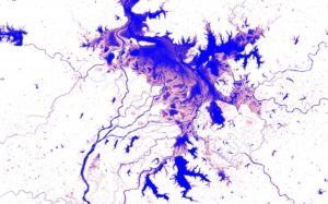
As the Earth’s surface water is intensely dynamic, our knowledge about where waterbodies can be found has not always been accurate. Waterbodies move, whole lakes dry up and new rivers and lakes form, which makes mapping these moving targets difficult.
Building on a project that combined thousands of years of computer time with millions of satellite images, the JRC’s Atlas of Global Surface Water Dynamics describes the important role that surface water plays for our planet’s climate and biodiversity, as well as virtually every aspect of our daily lives.
The Atlas documents the science behind a set of truly unique maps, which include time, and illustrates the changes in surface water resources over the past 35 years.
The scientists believe that the Atlas can improve our understanding of the consequences of climate change and human action on surface water resources, and that clearer understanding can help decision-makers to plan environmental actions and design effective policies aimed at the sustainable management of surface water resources.
…

Mapping the history of water
…
