by Ron Clutz, September 22, 2018 in ScienceMatters
People are overthinking and over-analyzing Arctic Ice extents, and getting wrapped around the axle (or should I say axis). So let’s keep it simple and we can all readily understand what is happening up North.
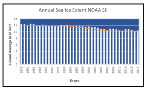
I will use the ever popular NOAA dataset derived from satellite passive microwave sensors. It sometimes understates the ice extents, but everyone refers to it and it is complete from 1979 to 2017. Here’s what NOAA reports (in M km2):
…