by K. Richard, Dec 30, 2024 in NoTricksZone
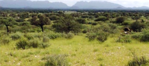
The greening of the Earth’s vegetated areas is “attributed to CO2 fertilization, climate change, and land use changes.”
New remote sensing research (Gutiérrez-Hernández and García, 2025) uses robust statistical methods to eliminate false positives and spurious correlations in establishing vegetation trends in the satellite era.
The scientists find 38% of the Earth’s land surface has undergone statistically significant greening or browning trends over the last 42 years (1982-2023). Conventional methods (i.e., Mann-Kendall test) that had previously found 51% of the Earth’s surface experienced statistically significant vegetation trends in the satellite era may overlook crucial factors that produce less accurate, inflated results.
With this new analytical method, the True Significant Trends (TCT) test, the authors have robustly determined there has been a “striking global greening trend” attributed to CO2 fertilization and climate change.
“Applying a new proposed workflow methodology (True Significant Trends, TST) we reveal a striking global greening trend, with a significant portion of the Earth’s terrestrial land surface showing increases in vegetation cover over the past four decades, particularly in Eurasia.”
Specifically, 76.1% to 85.4% of statistically significant vegetation trends indicate greening, whereas browning trends account for 14.7 to 23.9%
“Among these significant trends identified using the TST workflow, 76.07% indicated greening, while 23.93% indicated browning. Notably, considering areas (pixels) with NDVI values above 0.15, greening accounted for 85.43% of the significant trends, with browning making up the remaining 14.57%. These findings strongly validate the ongoing global greening of vegetation.”
…