by K. Richard, December 5, 2019 in NoTricksZone
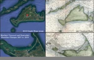
Surprisingly accurate nautical maps created the 17th to 19th centuries strongly suggest coastal land area in both hemispheres were quite similar to today’s. There is even evidence relative sea levels were higher than now back then.
Image Source: Etsy.com
Globally, coasts have grown since the 1980s
Between 1985 and 2015, satellite observations indicate the world’s coasts gained 13,565 km² more land area than they had lost to the seas (Donchyts et al., 2016).
This means more coastal land area is above sea level today than in the 1980s.
This surprises scientists, as they “expected the coast would start to retreat due to sea level rise,” but instead they observed “coasts are growing all over the world.”
…