by Dr Ludger Laurenz, May 30, 2021, in NoTricksZone
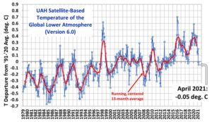
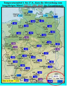
So far, much of Europe has seen a cold and wet 2021. It may be related to solar cycles.
An essay at Die kalte Sonne by Dr. Ludger Laurenz looks at the relationship between solar activity and weather trends, and believes this summer’s temperature will be 1.5°C lower.
There are many scientific opinions about solar activity’s impact on weather and climate, which differ and contradict each other. For example, a new publication by Leamon et al. provides an important building block for uncovering solar influence. Background here.
Solar influence in historical climate data substantiated
In the Leamon et al publication, the authors looked at the 22-year Hale solar cycles and saw it is possible to detect and substantiate solar influence in historical climate data (from tropical ocean surface temperature to temperature, sunshine, and precipitation data) and to make quantitative statements about the influence of solar activity on weather data.
Norway winter temperature and sun: “high statistical significance”
“Using the alternating years between Hale cycles, a correlation between the 22-year Hale cycle of the Sun and the trend of winter temperature in the polar night of Norway can be demonstrated with high statistical significance,” Dr Laurenz adds.
“Parallel to the temperature trend, the solar influence of the Hale cycles is also evident in the index values of the North Atlantic and Arctic Oscillations,” says Laurenz in addition. “Evidence of the influence of solar activity in the polar night of Scandinavia demonstrates that differences in solar activity are transmitted to the near-surface temperature via amplification mechanisms such as change in circulation patterns in the North Atlantic and Arctic Oscillations.”
The sun’s role in weather patterns is a great significance, and so CO2 is not the main driver at all.
…