Archives par mot-clé : Atlantic

No, BBC, Atlantic Hurricane Season Did Not Break Records

by P. Homewood, Dec 1, 2024 in NotaLotofPeopleKnowThat


The 2024 Atlantic hurricane season is coming to an end and it has been an active one overall.

There have been 18 named tropical storms, with 11 of those reaching hurricane strength and five becoming major hurricanes – category three and above.

An average season would bring 14 storms, seven hurricanes and three major hurricanes.

Some records have been equalled or broken but the active weather was not spread evenly across the season. In fact the middle of the season, normally the peak, was very quiet.

https://www.bbc.co.uk/weather/articles/cp87g4p73kxo

.

Despite claims of “records broken”, the BBC makes no mention of what these might be!

Unsurprising, because no records were broken, unless you count Beryl which was claimed to be the earliest Cat 5 on record, which has no significance whatsoever.

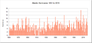
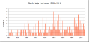
Instead, although above average, the number of hurricanes and major ones were not exceptional at all.

The Atlantic Is Cooling at a Mysteriously Fast Rate After Record Warmth

by P. Homewood, Aug 25, 2024 in NotaLotofPeopleKnowThat


For over a year, surface temperatures in the Atlantic Ocean hit new highs, but that trend has reversed at record speed over the past few months, and nobody knows why.

In June, temperatures in the Atlantic were 2 to 5 degrees Fahrenheit (1 to 3 degrees Celsius) hotter than normal in much of the ocean, with some areas getting as much as 9 degrees F (5 degrees C) warmer than average. Those temperatures weren’t a one-off, as the Atlantic had regularly seen record-breaking levels since March 2023. That year marked the fourth in a row that the world’s oceans set new heat records.

The hot water was partially a result of human-caused climate change, but it was also due to a particularly strong El Niño in 2023 and 2024. But that system appears to have passed, according to the National Oceanic and Atmospheric Administration.

NOAA data shows Atlantic sea surface temperatures have cooled at a surprising rate since May. Since June began, temperatures have been a degree or two Fahrenheit colder than normal for this time of year. That means El Niño will likely be replaced by its counterpart, La Niña, a weather system that allows cold water to rise to the surface of the Atlantic, some time between September and November. Both El Niño and La Niña are complex systems driven by trade winds, solar heating, and rainfall in the tropic regions, and can be difficult to predict. Still, the sudden shift in Atlantic temperatures has been puzzling, and nobody seems to know why it’s happened so quickly.

“We’ve gone through the list of possible mechanisms, and nothing checks the box so far,” Frans Philip Tuchen, a postdoctoral student at the University of Miami, told New Scientist.

https://gizmodo.com/the-atlantic-is-cooling-at-a-mysteriously-fast-rate-after-record-warmth-2000488967

.So they do not have a clue why the Atlantic has suddenly got colder, but they think they know that global warming made it hotter in the first place, even though there is no physical for the claim that a slightly warmer atmosphere can make any measurable difference to ocean temperatures!

They also get their knickers in a complete twist stating that El Ninos in the Pacific raise SSTs in the Atlantic!

North Atlantic’s marine productivity may not be declining, according to new study of older ice cores

by Universiy of Washington, Nov 13, 2023 in PhysOrg


To paraphrase Mark Twain, reports of declining phytoplankton in the North Atlantic may have been greatly exaggerated. A prominent 2019 study used ice cores in Antarctica to suggest that marine productivity in the North Atlantic had declined by 10% during the industrial era, with worrying implications that the trend might continue.

But new research led by the University of Washington shows that —on which larger organisms throughout the marine ecosystem depend—may be more stable than believed in the North Atlantic. The team’s analysis of an going back 800 years shows that a more complex atmospheric process may explain the recent trends.

The study was published in the Proceedings of the National Academy of Sciences.

NEW STUDY: “Part Of North Atlantic Is Cooling”…”Natural Fluctuations Have Been Primary Reason”

by P. Gosselin, Apr 30, 2022 in NoTricksZone


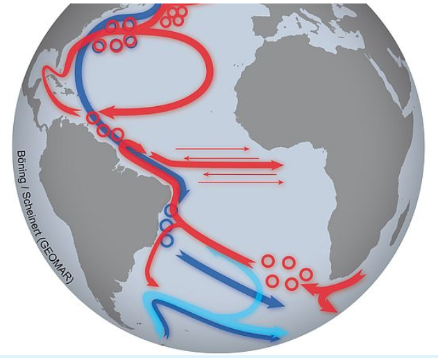
New studies on the Atlantic current system assess the threshold between natural fluctuations and a climate change-driven evolution

25 April, 2022/Kiel, Germany. With a new publication in the scientific journal Nature Climate Change, researchers from Kiel once again contribute to the understanding of changes in the Atlantic Meridional Overturning Circulation (AMOC) – also known as the “Gulf Stream System”. It is important both for the global climate as well as for climate events in Europe. The authors focus on the question whether human-induced climate change is already slowing down this oceanic circulation. According to the new study, natural variations are still dominant. Improved observation systems could help detect human influences on the current system at an early stage.

Is the Atlantic Meridional Overturning Circulation (AMOC) slowing down? Is this system of ocean currents, which is so important for our climate, likely to come to a halt in the future? Are the observed variations a natural phenomenon or are they already caused by human-induced climate change? Researchers from various scientific disciplines use a wide range of methods to better understand the gigantic oceanic circulation.

“The AMOC provides Europe with a mild climate and determines seasonal rainfall patterns in many countries around the Atlantic. If it weakens over the long term, this will also affect our weather and climate. Other consequences could be a faster rise in sea levels at some coasts or a reduction in the ocean’s ability to take up carbon dioxide and mitigate climate change”, Professor Dr. Mojib Latif, Head of the Research Unit: Marine Meteorology at GEOMAR Helmholtz Centre for Ocean Research Kiel, explains. “We depend on the AMOC in many ways – but so far, we can only guess how it will develop, and whether and how strongly we humans ourselves will push it towards a tipping point where an unstoppable collapse will take its course.”

Using observational data, statistical analyses and model calculations, a team led by Professor Latif has therefore examined changes in the current system over the past one hundred years in greater detail. The results have now been published in the scientific journal Nature Climate Change. According to the researchers, part of the North Atlantic is cooling – a striking contrast to the majority of ocean regions. All evaluations indicate that since the beginning of the 20th century, natural fluctuations have been the primary reason for this cooling. Nonetheless, the studies indicate that the AMOC has started to slow down in recent decades.

Predicting Atlantic Hurricanes Using Machine Learning

by V. Herrera et al., Apr 2002, in AtmosphereMPDI


Every year, tropical hurricanes affect North and Central American wildlife and people. The ability to forecast hurricanes is essential in order to minimize the risks and vulnerabilities in North and Central America. Machine learning is a newly tool that has been applied to make predictions about different phenomena. We present an original framework utilizing Machine Learning with the purpose of developing models that give insights into the complex relationship between the land–atmosphere–ocean system and tropical hurricanes. We study the activity variations in each Atlantic hurricane category as tabulated and classified by NOAA from 1950 to 2021. By applying wavelet analysis, we find that category 2–4 hurricanes formed during the positive phase of the quasi-quinquennial oscillation. In addition, our wavelet analyses show that super Atlantic hurricanes of category 5 strength were formed only during the positive phase of the decadal oscillation. The patterns obtained for each Atlantic hurricane category, clustered historical hurricane records in high and null tropical hurricane activity seasons. Using the observational patterns obtained by wavelet analysis, we created a long-term probabilistic Bayesian Machine Learning forecast for each of the Atlantic hurricane categories. Our results imply that if all such natural activity patterns and the tendencies for Atlantic hurricanes continue and persist, the next groups of hurricanes over the Atlantic basin will begin between 2023 ± 1 and 2025 ± 1, 2023 ± 1 and 2025 ± 1, 2025 ± 1 and 2028 ± 1, 2026 ± 2 and 2031 ± 3, for hurricane strength categories 2 to 5, respectively. Our results further point out that in the case of the super hurricanes of the Atlantic of category 5, they develop in five geographic areas with hot deep waters that are rather very well defined: (I) the east coast of the United States, (II) the Northeast of Mexico, (III) the Caribbean Sea, (IV) the Central American coast, and (V) the north of the Greater Antilles.

Scientists Discover Plate Tectonics… Again

by D. Middleton, Feb 5, 2021 in WUWT


An upwelling of rock beneath the Atlantic may drive continents apart
The Mid-Atlantic Ridge may play a more active role in plate tectonics than thought

By Maria Temming

FEBRUARY 4, 2021

An upsurge of hot rock from deep beneath the Atlantic Ocean may be driving the continents on either side apart.

The Americas are moving away from Europe and Africa by a few centimeters each year, as the tectonic plates underlying those continents drift apart. Researchers typically think tectonic plates separate as the distant edges of those plates sink down into Earth’s mantle, creating a gap (SN: 1/13/21). Material from the upper mantle then seeps up through the rift between the plates to fill in the seafloor.

But new seismic data from the Atlantic Ocean floor show that hot rock is welling up beneath a seafloor rift called the Mid-Atlantic Ridge from hundreds of kilometers deep in Earth’s mantle. This suggests that material rising up under the ridge is not just a passive response to tectonic plates sliding apart. Rather, deep rock pushing toward Earth’s surface may be driving a wedge between the plates that helps separate them, researchers report online January 27 in Nature.

A better understanding of plate tectonics — which causes earthquakes and volcanic eruptions — could help people better prepare for these natural disasters (SN: 9/3/17).

North Atlantic Oscillation

by P. Homewood, March 19, in NotaLotofPeopleKnowThat


If you had not noticed (!), it has been a mild and wet start to the year here in the UK, and also across in NW Europe.

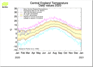
No doubt this will be linked to global warming in due course, but in fact it is simply weather, as the CET chart below proves:

Since the year started, temperatures have consistently been within the normal band. In other the sort of temperatures commonly seen at this time of year.

However, they have also been consistently in the top half of that band, rather than being spread between cold and warm, as would happen most years.

The reason for the weather we have had is, of course, the jet stream, or more precisely the North Atlantic Oscillation (NAO), which has been strongly and stubbornly positive all winter.

The Norwegian Centre for Climate Research CICERO spotted this mild weather coming back in December, and commented on 6th January:

The unusual warm temperatures this winter and forecasts indicating milder winter conditions for January, February and March in Europe are partly due to an atmospheric circulation pattern called the North Atlantic Oscillation, or NAO. This atmospheric circulation pattern explains well the weather we get in Europe, especially in winter.

https://cicero.oslo.no/no/posts/nyheter/unseasonal-temperatures-for-norway#


Our own Met Office explains the NAO phenomenon:


The 2019 Atlantic Hurricane Season

by P. Homewood, December 11, 2019 in NotaLotofPeopleKnowThat


The Atlantic hurricane season has now officially ended, so let’s check the numbers.

https://www.aoml.noaa.gov/hrd/tcfaq/E11.html

http://rammb.cira.colostate.edu/products/tc_realtime/season.asp?storm_season=2019

There have been six hurricanes in total, including three major ones, Dorian, Humberto and Lorenzo. Coincidentally both numbers are the same as the average since 1950.

According to NOAA’s Hurricane Research Division, many hurricanes were missed in the earlier decades. Systematic aircraft reconnaissance began in 1944, but this only covered half of the Atlantic basin, until daily satellite monitoring started in 1966.

Switching on the Atlantic heat pump

by Stockholm University, August 27, 2019 in WUWT/fromNature


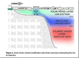
34 million years ago the warm ‘greenhouse climate’ of the dinosaur age ended and the colder ‘icehouse climate’ of today commenced. Antarctica glaciated first and geological data imply that the Atlantic meridional overturning circulation, the global ocean conveyor belt of heat and nutrients that today helps keep Europe warm, also started at this time. Why exactly, has remained a mystery.

“We have found a new trigger to explain the start-up of the Atlantic current system during the greenhouse-icehouse climate transition: During the warm climate, buoyant fresh water flooded out of the Arctic and prevented the ocean-sinking that helps power the conveyor. We found that the Arctic-Atlantic gateway closed due to tectonic forces, causing a dramatic increase in North Atlantic salinity. This caused warming of the North Atlantic and Europe, and kickstarted the modern circulation that keeps Europe warm today,” says David Hutchinson, researcher at the Department of Geological Sciences, Stockholm University, and lead author of the article published in Nature Communications.

The team of scientists, from the Bolin Centre for Climate Research, used a combination of geophysical data and climate modelling to show that the freshwater transport through the Arctic-Atlantic gateway plays a critical role in controlling the overturning circulation.

Slowest start to Atlantic Hurricane season since 2004

by Anthony Watts, August 7, 2019 in WUWT


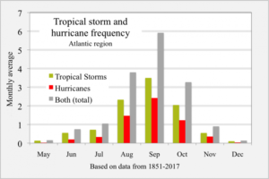
Watching the current maps and models, it appears the 2019 Atlantic Hurricane Season is off to a slow start. For people that the depend on disaster porn (climate alarmists, media) that means no weather events to claim as being climate driven.


Graph of tropical storm and hurricane frequency, Atlantic region, monthly, based on data from 1851-2017. Data from NOAA at http://www.aoml.noaa.gov/hrd/tcfaq/E17.html Landsea, Chris (contributor from the NHC). “Total and Average Number of Tropical Cylones by Month (1851-2017)”. aoml.noaa.gov. National Oceanic and Atmospheric Administration, Atlantic Oceanographic and Meteorological Laboratory. Archived from the original on September 1, 2018.  Graph from RCraig.

Ouragans en Atlantique : prévisions pour la saison 2019

by Regis Crepet, 2 juin 2019 in LaChaîneMétéo


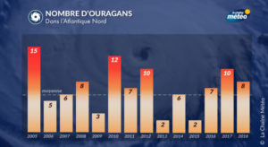
Ces deux dernières années ont été marquées par une activité cyclonique supérieure aux moyennes statistiques en Atlantique Nord, notamment en 2017 avec des phénomènes puissants tels Irma et Maria dans les Caraïbes. Cette année, alors que la saison démarre officiellement le 1er juin, nos prévisions sont plus rassurantes avec la perspective d’une activité cyclonique légèrement plus faible que la moyenne.


En ce début d’été météorologique, la saison cyclonique débute dans l’Atlantique nord (les ouragans). Cette saison s’étend officiellement du 1er juin au 30 novembre, avec un pic d’activité d’août à octobre. Il est donc l’heure pour les différents organismes météo de la planète et les météorologues et climatologues de La Chaîne Météo de se pencher sur les prévisions de cette saison à venir.

En 2017, la saison dans l’océan Atlantique nord a figuré parmi les plus actives depuis le début des relevés, avec des phénomènes dévastateurs (Harvey, Irma ou encore Maria dans les Caraïbes). Comme 2017, la saison 2018 s’est située au-dessus des moyennes (calculées par la NOAA d’après la période 1981/2010). Cette dernière saison a présenté, pour l’Atlantique nord, 15 phénomènes cycloniques, avec 8 ouragans dont 2 qui ont atteint la catégorie 3 sur 5, qualifiés alors de “majeurs”.

2019 Atlantic hurricane forecast

by J. Curry and J. Johnstone, June4, 2019 in ClimateEtc.


CFAN predicts an active North Atlantic hurricane season season.

The Atlantic hurricane has begun.  We are off to an early start with one wimpy subtropical storm that lasted less than a day, and a small system that is trying to spin up in the Bay of Campeche.

Other forecast providers have begun issuing forecasts:

  • NOAA predicts a near normal season with 4-8 hurricanes.
  • Tropical Storm Risk predicts slightly below normal activity, with 6 hurricanes and ACE of 88.
  • Colorado State University predicts near normal season:  6 hurricanes and ACE of 100

Climate Forecast Applications Network (CFAN) is going bold, see below. [link] to forecast report.

CFAN’s seasonal forecast

Table 1. Current (May) 2019 hurricane forecasts of North Atlantic ACE, North Atlantic total hurricanes, U.S. landfalling hurricanes. 

….

Cycles of Rapid Climate Warming

by Jim Steele, May 28, 2018 in WUWT


The globally averaged temperature rose 1.5°F from 1880 to today. Various narratives suggest the rise since 1950 was driven by increasing concentrations of CO2. The rising temperature before 1950 was considered natural. Since 1990, Arctic temperatures rose 2 to 3 times faster than the global average. So, are rapidly rising Arctic temperatures evidence of an impending climate crisis?

Astute students of climate history recall rapid Arctic warming has happened often and naturally. During the last Ice Age when CO2 concentrations were just half of today’s, 25 abrupt warming events happened. Arctic temperatures rose 9°F, and sometimes as much as 14°F in just 40 years. These rapid warming episodes are now called Dansgaard–Oeschger events (D-O events) in honor of the researchers who first detected them in Greenland’s ice cores. These D-O episodes affected global climate, changed ocean currents along California’s coast and altered the range of European forests.

What caused such abrupt warming? Basic physics dismisses changes in greenhouse gases or solar insolation because neither radiative effect induces such rapid warming. The most reasonable explanation suggests episodes of ventilating heat, that had accumulated in the Arctic Ocean, rapidly warmed the air.

New Study: The Tropical Atlantic Was 7.5°C Warmer Than Now While CO2 Was 220 ppm

by K. Richard, May 9, 2019 in NoTricksZone


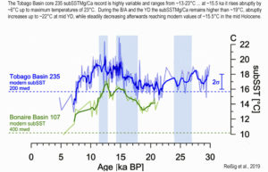
Another new paper published in Paleoceanography and Paleoclimatology casts further doubt on the paradigm that says CO2 has historically been a temperature driver.

Evidence from the tropical Atlantic indicates today’s regional temperatures (15.5°C) are 7.5°C colder than a peak temperatures (23°C) between 15,000 to 10,000 years ago, when CO2 hovered around 220 ppm.

The Shameful Politicization Of Hurricanes

by H.S. Burnett, September 26, 2018 in ClimateChangeDispatch


Here are several facts that dispel these myths.

First, although the Atlantic hurricane season is not over yet, thus far, the number of hurricanes occurring this year is below average.

During a typical six-month Atlantic hurricane season, 12 named storms form, six become hurricanes, and three of those become major hurricanes – meaning Category 3 or higher.

This season, 10 named storms have formed in the Atlantic Basin, three of which became hurricanes.

Two other hurricanes briefly became minor storms off the west coast of Africa – and only Florence became a major hurricane.

Furthermore, only one has made landfall in the United States: Florence.

Before the above-average Atlantic hurricane season of 2017, the United States experienced the longest period in recorded history, nine years, without a major hurricane (Category 3 or higher) striking the country.

Trends In Atlantic Hurricanes

by Paul Homewood, September 20, 2017 in NotaLotof PeopleKnowThat


It is worth re-emphasising these points:

  • Many storms were missed over the open ocean prior to hurricane hunter aircraft in 1944.

  • Even then half of the Atlantic basin was not covered.

  • Satellite coverage began to improve matters in 1966.

  • But even then monitoring has considerably improved since 1966, particularly regarding short lived storms.

    See also herehere and here