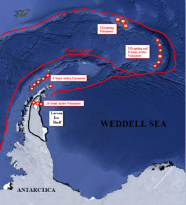
by K. Richard, March 15, 2021 in NoTricksZone
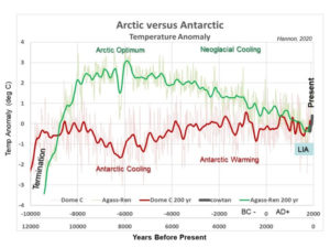
The IPCC-endorsed anthropogenic global warming (AGW) paradigm finds a warming Antarctica results in more precipitation locked up as ice on the continent. This contributes to reducing sea levels: a -1.2 mm/year−1 mitigation of sea level rise over the next 80 years.
In the 4th IPCC report, Working Group 1 (the physical science) reported that as global temperatures rise, “GCMs [models] indicate increasingly positive SMB for the Antarctic Ice Sheet as a whole because of greater accumulation.” This means that by 2100 Antarctica “would contribute 0.4 to 2.0 mm yr−1 of sea level fall.” Over the next 980 years, Antarctica’s ice accumulation will reduce sea levels by nearly a full meter (-0.8 m by 3000).
…