Archives par mot-clé : USA

WHY IS NORTH AMERICA IMMUNE TO GLOBAL WARMING?

by Cap Allon, Oct 9, 2020 in Electroverse


I’m not trying to be facetious here, but I don’t know what other stance climate alarmists can take. Every data point –even those from warm-mongers NOAA– reveals that the North American continent is cooling.

Taking NOAA’s data as read, with its Urban Heat Island (UHI) bias, it still reveals a sharp cooling trend across the U.S. and Canada from 2015 through 2019. A trend that has continued into 2020 with the majority of regions suffering a late start to summer, and, now, an early beginning to winter.

North America is currently bracing for its sixth or seventh (I’ve genuinely lost count) Arctic blast of the season. By next Monday (Oct 19) an enormous mass of polar cold will have engulfed 90+% of the continent:


See also  ACCORDING TO THE MSM, GLOBAL WARMING COULD STILL MAKE IT TOO COLD TO GROW CITRUS FRUITS IN SOUTHEAST U.S.

LIST OF HISTORICAL TEMPERATURE EXTREMES BY U.S. STATE SHOWS NO SIGN OF GLOBAL WARMING

by Cap Allon, Oct 10, 2020 in Electroverse


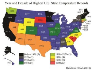
Below I’ve compiled a list of the hottest and coldest temperatures ever recorded in each U.S. state, according to NOAA data. Surely, if catastrophic global warming was actually a thing then it would show up in the temperature records. Spoiler: it doesn’t, and a discussion on why follows the list.

ALABAMA

– All-time highest temperature: 112° F (Centreville on Sept. 6, 1925)

– All-time lowest temperature: -27° F (New Market 2 on Jan. 30, 1966)

ALASKA

– All-time highest temperature: 100° F (Fort Yukon on June 27, 1915)

– All-time lowest temperature: -80° F (Prospect Creek on Jan. 23, 1971)

ARIZONA

– All-time highest temperature: 128° F (Lake Havasu City on June 29, 1994)

– All-time lowest temperature: -40° F (Hawley Lake on Jan. 7, 1971)

ARKANSAS

All-time highest temperature: 120° F (Ozark on Aug.10, 1936)

– All-time lowest temperature: -29° F (Gravette on Feb.13, 1905)

CALIFORNIA

– All-time highest temperature: 134° F (Greenland Ranch on July 10, 1913)


WISCONSIN

– All-time highest temperature: 114° F (Wisconsin Dells on July 13, 1936)

– All-time lowest temperature: -55° F (Couderay 7 W on Feb. 4, 1996)

WYOMING

– All-time highest temperature: 115° F (Basin on Aug. 8, 1983)

– All-time lowest temperature: -66° F (Riverside Ranger Station, Yellowstone National Park) on Feb. 9, 1933)

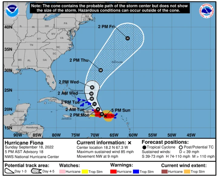
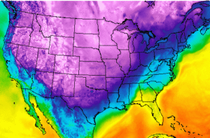
More than 210 degrees Fahrenheit separates the highest and the lowest temperatures on record in the United States, and it isn’t a coincidence that the majority of these temperatures records –for both hot and cold– occur during solar minimums.

This is because low solar activity weakens the jet stream, reverting its usual tight ZONAL flow to more of a wavy MERIDIONAL one. This violent “buckling” effect FULLY explains how regions can experience pockets of anomalous heat while others, even relatively nearby, can be dealing with blobs of record cold: basically, in the NH, Arctic cold is dragged anomalously far south and Tropical warmth is pushed unusually far north (for more see the two links below)

Scientists Find Peak 1940s Warmth, Post-1950s Cooling In The Same Western US Region Where Hockey Sticks Emerged

by K. Richard, Sep 24, 2020 in NoTricksZone


A new 1735-2015 temperature reconstruction (Heeter et al., 2020) using Western US tree ring proxies shows peak 1940s warmth and post-1950s cooling. This is the same region Dr. Michael Mann used tree ring data to construct his famous hockey stick graph.

A new Scandinavian temperature reconstruction (Seftigen et al., 2020) that’s “skillfull in characterizing past temperature changes over the past one to two millennia” finds there

HUNDREDS OF ALL-TIME LOW TEMPERATURE RECORDS TUMBLED OVER THE PAST 24HRS — MSM SILENT

by Cap Allon, Sep 20, 2020 in Electroverse


A nation-spanning mass of Arctic air has parked itself over the eastern half of North America of late, rewriting the record-books in many states, districts, and provinces, including in New York, Washington, and Ontario.

The city of Syracuse, NY tied an all-time record low of 34F (1.1C) on Saturday morning, just after 6AM, a feat originally achieved back in 1943–duringsolar minimum of cycle 17.

Buffalo also tied a low temperature record — the 38F (3.3C) registered on Saturday matched the record low for the day set back in 1995–solar minimum of cycle 22.


Al Gore Uses Heatwaves, Wildfires To Fuel Global Warming Angst

by V. Richardson, Sep 9, 2020 ClimateChangeDispatch


A burst of wild September weather brought a “climate crisis” warning Tuesday from Al Gore as Californians struggled with heat and wildfires, Atlantic storm trackers raced through the alphabet and Coloradans traded their flip-flops for snow boots.

California firefighters fought to contain 23 active fires that charred a record 2.3 million acres as the state headed into the peak of its fire season fueled by a heatwave. On Sunday, the Los Angeles County town of Woodland Hills set a record at 121 degrees.

“It reached a record high of 121 degrees F in LA county over the weekend,” Mr. Gore tweeted Tuesday. “Extreme heat is fueling a longer, more intense, and more destructive wildfire season in CA. This is what an unabated climate crisis looks like.”

In a warming climate, temperatures become more stable, not less, because the differences between the poles and the equator become smaller, Mr. Taylor said.

“Assuming for the sake of argument that a large temperature swing is a crisis like climate alarmists assert, global warming will make such temperature swings less likely and severe,” he said. “So this is happening despite our recent modest warming, not because of it.”

NuScale SMR receives US design certification approval

by World Nuclear News, September 1, 2020


The US Nuclear Regulatory Commission (NRC) has issued a final safety evaluation report (FSER) for NuScale’s small modular reactor. This is the first-ever FSER to be issued by the NRC for an SMR, and represents the completion of the technical review and approval of the design.


….

The NuScale design uses passive processes such as convection and gravity in its operating systems and safety features to produce about 600 MW of electricity. Twelve modules, each producing 50 MW, are submerged in a safety-related pool built below ground level. The NRC has concluded the design’s passive features “will ensure the nuclear power plant would shut down safely and remain safe under emergency conditions, if necessary”, it said. NuScale has also indicated to NRC it will apply for standard design approval of a version using 60 MW modules, the regulator said. This would require additional NRC review.

Stop Blaming Climate Change For California’s Fires–Michael Schellenberger

by P. Homewood, August 26, 2020 in NotaLotofPeopleKnowThat


It’s Not About The Climate

Nobody denies climate change is occurring and playing a role in warmer temperatures and heatwaves. Keeley notes that, since 1960, the variation in spring and summer temperatures explain 50% of the variation in fire frequency and intensity from one year to the next.

But the half-century since 1960 is the same period in which the U.S. government promoted, mostly out of ignorance, the suppression of regular fires which most forests need to allow for new growth.

For much of the 20th Century, U.S. agencies and private landowners suppressed fires as a matter of policy. The results were disastrous: the accumulation of wood fuel resulting in fires that burn so hot they sometimes kill the forest, turning it into shrubland.

The US government started to allow forests in national parks to burn more in the 1960s, and allowed a wider set of forests on public lands to burn starting in the 1990s.

“When I hear climate change discussed it’s suggested that it’s a major reason and it’s not,” Scott Stevens of the University of California, Berkeley, told me.

Redwood forests before Europeans arrived burned every 6 to 25 years. The evidence comes from fire scars on barks and the bases of massive ancient trees, hollowed out by fire, like the one depicted in The New York Times photograph.

“There was severe heat before the lightning that dried-out [wood] fuel,” noted Stevens. “But in Big Basin [redwood park], where fire burned every seven to ten years, there is a high-density of fuel build-up, especially in the forests.”

Media Blame Isaias On Climate Change – As Hurricane Numbers Decline

by H.S. Burnett, August 10, 2020 in ClimateChangeDispatch


Hurricane Isaias hadn’t even made landfall in the United States before the media began proclaiming Isaias was the result of human-caused climate change.

Not only is there no evidence for such a claim, but hurricane numbers have been declining as global temperatures modestly warm.

Also, even the United Nations Intergovernmental Panel on Climate Change (IPCC) disputes any connection between global warming and hurricanes.

Satellite survey shows California’s sinking coastal hotspots

by Arizona State University, August 2, 2020 in WUWT


A majority of the world population lives on low lying lands near the sea, some of which are predicted to submerge by the end of the 21st century due to rising sea levels.

The most relevant quantity for assessing the impacts of sea-level change on these communities is the relative sea-level rise – the elevation change between the Earth’s surface height and sea surface height. For an observer standing on the coastland, relative sea-level rise is the net change in the sea level, which also includes the rise and fall of the land beneath observer’s feet.

Now, using precise measurements from state-of-the-art satellite-based interferometric synthetic aperture radar (InSAR) that can detect the land surface rise and fall with millimeter accuracy, an Arizona State University research team has, for the first time, tracked the entire California coast’s vertical land motion.

They’ve identified local hotspots of the sinking coast, in the cities of San Diego, Los Angeles, Santa Cruz and San Francisco, with a combined population of 4 to 8 million people exposed to rapid land subsidence, who will be at a higher flooding risk during the decades ahead of projected sea-level rise.

“We have ushered in a new era of coastal mapping at greater than 1,000 fold higher detail and resolution than ever before,” said Manoochehr Shirzaei, who is the principal investigator of the NASA-funded project. “The unprecedented detail and submillimeter accuracy resolved in our vertical land motion dataset can transform the understanding of natural and anthropogenic changes in relative sea-level and associated hazards.”

The results were published in this week’s issue of Science Advances (DOI link here).

HIGHEST U.S. TEMPERATURES ON RECORD BY STATE

by Cap Allon, July 12, 2020 in Electroverse


Historical documentation destroys the man-made global warming theory.

While those in control of the temperature graphs are all too happy to fraudulently increase the running average, what they haven’t (yet) had the balls to do is rewrite the history books.

As Tony Heller uncovers on his site realclimatescience, NASA routinely cools the past and heats the present, so to give the illusion of a greater warming trend — and comparisons between old and new graphs instantly reveals this fraud:

In 1999, NASA’s James Hansen reported 0.5C US cooling since the 1930’s:

By 2016, the same NASA graph has eliminated that 1930-1999 cooling:

WASHINGTON, D.C. JUST SUFFERED ITS COLDEST MAY SINCE 2005

by Cap Allon, June 2, 2020 in Electroverse


Like April, May was cooler than average across the District,” admits filthy warm-mongers the washingtonpost.com in a recent article. The month officially logged an average temperature of just 63.8F, which is 2.2F below the 30-year average, and made for Washington’s coldest May in 15 years.

The average temperature more closely matched a typical May in New York City, points out the Southeast Regional Climate Center. And with NYC located some 200 miles north of Washington, May 2020 serves as a great illustration of how the GSM is driving the COLD LINE south.

The past two months also marked the first time since 2003 that both April and May were colder than average across the District.

In addition, May 9’s daily high of 52F was the lowest-high during the month of May since May 12, 2008 (solar minimum of cycle 23), and the chill even brought a few snow flurries to Washington’s far north and west suburbs. That 52F on May 9 also matched the record lowest-high for the date which was set way back in 1877 (solar minimum of cycle 11).

Many more all-time cold-records fell across the District that day; including Dulles smashing its record for min-high from 1977 (solar minimum of cycle 20), and Baltimore toppling both its all-time min-low from 1966 (solar minimum of cycle 19) as well as its min-high set back in 1977 (solar min of cycle 20)and 1947 (solar min of cycle 17).

Destroying the environment to save it

by Ch. Rotter, May 31, 2020 in WUWT


Pseudo-green energy will wreak devastation, pretending to prevent exaggerated climate harm

Paul Driessen

“We had to destroy the village in order to save it.” The infamous Vietnam era quotation may or may not have been uttered by an anonymous US Army major. It may have been misquoted, revised, apocryphal or invented. But it quickly morphed into an anti-war mantra that reflected attitudes of the time.

For Virginians and others forced to travel the path of “clean, green, renewable, sustainable” energy, it will redound in modern politics as “We had to destroy the environment in order to save it.”

Weeks after Governor Ralph Northam signed Virginia’s “Clean Economy Act,” which had been rushed through a partisan Democrat legislature, Dominion Energy Virginia announced it would reach “net zero” greenhouse gas emissions by 2050. To do so, the utility company will raise family, business, hospital and school electricity bills by 3% every year for the next ten years – as these customers and state and local governments struggle to climb out of the financial holes created by the ongoing Coronavirus lockdown.

Just as bad, renewable energy mandates and commitments from the new law and Dominion’s “integrated resource plan” will have major adverse impacts on Virginia and world environmental values. In reality, Virginia’s new “clean” economy exists only in fantasy land – and only if we ignore “clean” energy CO2 emissions, air and water pollution, and other environmental degradation around the world.

Dominion Energy plans to expand the state’s offshore wind, onshore solar and battery storage capacity by some 24,000 megawatts of new “renewable” energy by 2035, and far more after that. It will retain just 9,700 MW of existing natural gas generation, and only through 2045, build no new gas-fired units, and retire 6,200 megawatts of coal-fired generation. This will reduce in-state carbon dioxide emissions, but certainly won’t do so globally. The company intends to keep its four existing nuclear units operating.

To “replace” some of its abundant, reliable, affordable fossil fuel electricity, Dominion intends to build at least 31,400 megawatts of expensive, unreliable solar capacity by 2045. The company estimates that will require a land area some 25% larger than 250,000-acre Fairfax County, west of Washington, DC. That means Dominion Energy’s new solar facilities will blanket 490 square miles (313,000 acres) of beautiful croplands, scenic areas and habitats that now teem with wildlife.

Asteroid, climate change not responsible for mass extinction 215 million years ago

by Todd McLeish, May 27, 2020 U. of RhodeIsland in PhysOrg


A team of University of Rhode Island scientists and statisticians conducted a sophisticated quantitative analysis of a mass extinction that occurred 215 million years ago and found that the cause of the extinction was not an asteroid or climate change, as had previously been believed. Instead, the scientists concluded that the extinction did not occur suddenly or simultaneously, suggesting that the disappearance of a wide variety of species was not linked to any single catastrophic event.

Their research, based on paleontological field work carried out in sediments 227 to 205 million years old in Petrified Forest National Park, Arizona, was published in April in the journal Geology.

..

Scientists “Discover” Largest Shield Volcano on Earth

by D. Middleton, May 15, 2020 in WUWT


And it’s not Mauna Loa…

UH researchers reveal largest and hottest shield volcano on Earth
Posted on May 13, 2020 by Marcie Grabowski

In a recently published study, researchers from the University of Hawai‘i at Mānoa School of Ocean and Earth Science and Technology revealed the largest and hottest shield volcano on Earth. A team of volcanologists and ocean explorers used several lines of evidence to determine Pūhāhonu, a volcano within the Papahānaumokuākea Marine National Monument, now holds this distinction.

Geoscientists and the public have long thought Mauna Loa, a culturally-significant and active shield volcano on the Big Island of Hawai‘i, was the largest volcano in the world. However, after surveying the ocean floor along the mostly submarine Hawaiian leeward volcano chain, chemically analyzing rocks in the UH Mānoa rock collection, and modeling the results of these studies, the research team came to a new conclusion. Pūhāhonu, meaning ‘turtle rising for breath’ in Hawaiian, is nearly twice as big as Mauna Loa.

“It has been proposed that hotspots that produce volcano chains like Hawai‘i undergo progressive cooling over 1-2 million years and then die,” said Michael Garcia, lead author of the study and retired professor of Earth Sciences at SOEST. “However, we have learned from this study that hotspots can undergo pulses of melt production. A small pulse created the Midway cluster of now extinct volcanoes and another, much bigger one created Pūhāhonu. This will rewrite the textbooks on how mantle plumes work.”

[…]

University of Hawai‘i at Mānoa School of Ocean and Earth Science and Technology

PARTS OF UK AND US SUFFER THEIR LOWEST MAY TEMPERATURES ON RECORD

by  Cap Allon, May 14, 2020 in Electroverse


Parts of the UK and US have suffered their lowest May temperatures on record of late, according to data from filthy warm-mongers & partners-in-crime the Met Office and NOAA.

While the official li(n)e coming out of these agencies is that our World Is On Fire, thermometer stations the length and breadth of both Europe and North America are telling a rather different story.

Overnight Wednesday (May 13-14), the mercury in Katesbridge and Castlederg, N. Ireland, plummeted to an extra-duvet-grabbing -6.1C (21F) and -3.9C (25F), respectively, as a wave of brutal Arctic air rode anomalously-far south on the back on a meridional (wavy) jet stream flow.

Wednesday night followed what had been a record-chilly day — a minimum temperature of -5C (23F)was observed in Tulloch Bridge, Scotland.

The wave of record cold actually engulfed much of Northern Europe overnight Wednesday, as visible in coolwx.com‘s temperature animation:


Record Cold May Weather Hits the U.S. — Climate Alarmists Blame Global Warming

by J. Murphy, May 11, 2020 in NewAmerican


Almost a full two months after the season officially ended, winter reared its ugly head in much of the United States over the weekend. A winter-type Polar Vortex has caused record cold and extremely late season snow from the Rockies to the Atlantic Ocean. What’s responsible for this late season cold? If you listen to climate alarmists, the answer is simple: global warming.

In the Northeast, higher elevation areas reported snowfalls of up to 10 inches over the weekend. New York City received a trace of snow on May 9, tying the city’s record for the latest snowfall. In Islip, New York, a town of the southern shore of Long Island, the month of May was officially snowier than the month of February. Mother’s Day celebrations across the Midwest and Northeast were ruined by cold and windy conditions in the regions. Near record cold temperatures were reported from the Dakotas stretching down Texas and across most of the eastern United States.


Continuer la lecture de Record Cold May Weather Hits the U.S. — Climate Alarmists Blame Global Warming

Rural Northern US Stations Showed No Warming – Before NASA Rewrote The Data

by P. Gosselin, May 03, 2020 in NoTricksZone


The northern hemisphere surface temperature was expected to drop substantiallyaccording to NCEP, but this of course will not keep global warming alarmists from sounding the warming alarms.

But a look at the unadjusted data from some rural US stations tells us that there has been no warming.

Today we look at temperature data from NASA of some stations along the northern US with a Brightness Index (BI) of 0, meaning rural locations with no urban heat island effects. We want to see the trend over the past 100 or so years.

Plotted are the USHCN Version 4 versus Version 4 adjusted.

The first plots are the data from Lincoln, Nebraska going back to 1901:

Modest cooling changed to warming. Data: NASA

Note how a modest cooling trend was changed to a warming trend. Very ealy temperatures were cooled by 2°C!

Next we move to the Livingston, Montana station, where here as well a modest cooling trend was transformed into warming by massively adjusting past temperatures downward also by more than 2°C:

Largest Bakken Producer Shuts In Almost All Production

by D. Middleton, April 26, 2020 in WUWT


Continental Resources has also declared force majeure on current contracts to deliver crude oil at current prices. Legal experts are dubious regarding their force majeure claim. Continental, one of the most financially successful “shale” players, does not hedge production and was, therefore, highly exposed to the sudden price drop.

Also here  Another Failed Energy Prediction: Peak Oil Demand

Did heavy rains trigger the eruption of the most dangerous U.S. volcano? Scientists are skeptical

by  RP Ortega, April 22, 2020 in ScienceAAAS


In May 2018, Hawaii’s Kilauea volcano let loose its largest eruption in 200 years, spewing plumes of ash high into the air, and covering hundreds of homes in lava. The eruption terrified local residents, but it gave scientists a once-in-a-lifetime opportunity to study the volcano’s explosive behavior. Now, a new study claims that extreme rainfall boosted underground pressures and was the “dominant factor” in triggering the eruption.

It’s not the first time rainfall has been linked to volcanic activity, says Jenni Barclay, a volcanologist at the University of East Anglia who was not involved in the new work. Previous research suggests storms passing over Mount St. Helens may have played a role in explosive activity between 1989 and 1991. And intense rains fell shortly before and during the activity of Montserrat’s Soufrière Hills volcano from 2001 to 2003. Rain may have also triggered eruptions of Réunion’s Piton de la Fournaise volcano. Still, Barclay believes rain is, at best, a contributing factor to volcanic eruptions and not the main driver. “It’s a series of coincident events that have led to the triggering of this larger episode,” she says.

Researchers on the new study used satellite data from NASA and Japan’s space agency to estimate rainfall during the first months of 2018, before the start of the eruption. More than 2.25 meters of rain fell on the volcano in the first months of 2018, the researchers found. They created a model to show how the accumulated rainfall could seep into the pore spaces in rocks deep underground, boosting pressures that eventually caused fissures in the volcano’s flank to open up and release magma. When they looked at records of previous Kilauea eruptions going back to 1790, they found that 35—more than half—started during the nearly 6-month rainy season.

‘Arctic April’ Grips N. America Breaking Hundreds Of Cold Records

by Cap Allon, April 16, 2020 in ClimateChangeDispatch


Record cold and snowfall hit many parts of North America over the Easter weekend, continuing what has so far been a largely Arctic April.

Records were toppled across many U.S. states, with Montana, Iowa, South Dakota, and Colorado seemingly worst hit.

A winter storm system moved through Iowa on Sunday delivering between three inches and a foot to the majority of locations — several northern Iowa towns saw all-time records tumble:

The 3.7 inches that fell at Sioux Gateway Airport broke the record for April 12th; it also made it the second-highest Easter snowfall ever behind the 4.7 inches during Easter 1929.

The town of Ringsted in Emmet County (also Iowa) came in with a record-busting 11 inches.

Robert “Lightning” Petersen was the man to log the accumulation — he uses his back yard measuring equipment to keep track of snow and rainfall. He works in concert with the National Weather Service out of Johnston.

RECORD SNOWFALL BURIES UPPER MIDWEST — SIERRA NEVADA MOUNTAINS TO SEE 4-FEET ON SUNDAY — NH SNOW MASS 500 GIGATONS ABOVE 1982-2012 AVERAGE

by Cap Allon, April 5, 2020 in Electroverse


According to abcnews.go.com and the NWS, seven states from Minnesota to Kansas were under ice and snow alerts on Friday, while forecasts for the West see 4-feet of snow falling over the Sierra through Sunday alone.

Thursday, April 2 saw record Spring snowfall bury the Upper Midwest.

In Grand Forks, North Dakota, a whopping 10 inches (25.4 cm) of global warming goodness was measured; while Fargo, North Dakota, saw snow totals touch 5 inches (12.7 cm).

Wyoming was handed the largest accumulations — a recording busting 21 inches (53.3cm).

This cold front continued its slow southerly march overnight Thursday, and reached southeastern Texas by Friday afternoon — the biggest impacts here were severe thunderstorms, damaging winds, golf-ball size hail, and the odd tornado. Heavy rain also reportedly produced some flash flooding.

A new storm rolled into the West Coast on Saturday bringing heavy rain to the California coast. Looking forward to Sunday, staggering April snow totals of up to 4 FEET are forecast to bury the Sierra Nevada Mountains:

The significance of these snow totals cannot be overemphasized.

This is how glaciers form.

This is also how ice ages begin.

The COLD TIMES are returning in line with historically low solar activitycloud-nucleating Cosmic Rays, and a meridional jet stream flow.

Even NASA agrees, in part at least, with their forecast for this upcoming solar cycle (25) revealing it will be “the weakest of the past 200 years,” with the agency correlating previous solar shutdowns to prolonged periods of global cooling here.

Extra warm U.S. winter had nature’s thumbprint on it–Joe Bastardi

by P. Homewood, April 3; 2020 in NotaLotofPeoppleKnowThat


Joe Bastardi explains why this winter has been so mild in the US, but also across N Europe, at CFACT.

Two points:

1) I will make the case for why such winters like this happen

2) I will point out that nowhere in this article did the massive natural physical drivers that far outweigh the effect of CO2, which is only .041% of the atmosphere. Pointedly, of which man is only responsible for  25% and the US only 15% of that total.

I am not going to waste time attacking here, except to say this kind of one-sided journalism and the fact that nowhere did anyone show what I am about to reveal to you, should raise questions of any objective person.

Basically the rules of the game are, if its warm like this winter, its climate change, if it is cold, its climate change. It is typical of everyone gets a trophy in that any answer even if opposite, means you get credit.

I won’t copy the whole article as it is a bit technical, but it can be seen here. However these are the main points Joe raises, starting with the role of El Nino and water vapour:

Water vapor is by far the most important greenhouse gas when it comes to the planetary weather and climate. Meteorologist look at “saturation mixing ratios” which show a correlation of water vapor to temperature. Basically the colder and drier the air mass, the more the introduction of water vapor will lead higher temperatures, there is no place like the arctic to prove this is the case. The cyclically warmed oceans have put more water vapor (and CO2) into the air. When Super El Niño’s go off, the immense amounts dispersed lead to a step up of the temperature. The colder regions leading the way as will be opined on below.

A chunk of Yellowstone the size of Chicago has been pulsing. Why?

by R.G. Andrews, March 19, 2020 in NationalGeographic


An injection of magma under Norris Geyser Basin may be why the region is five inches higher today than it was 20 years ago.

In northwestern Wyoming, in the center of Yellowstone National Park, a bubbling caldera is the scar of a 640,000-year-old, gargantuan volcanic eruption. The 3,472-square-mile park encompassing the caldera is filled with geologic wonderlands of sprouting geysers and effervescing pools, all ultimately driven by magma and superheated fluids churning in the rock below the surface.

One of these areas, Norris Geyser Basin to the northwest of the caldera, contains more than 500 hydrothermal features. These tempestuous geysers and pools often change from day to day, but a much larger transformation has been taking place as well: For more than two decades, an area larger than Chicago centered near the basin has been inflating and deflating by several inches in erratic bursts. In a hyperactive volcanic region like Yellowstone, the exact causes of any specific movement are difficult to pin down. But a recent study in the Journal of Geophysical Research: Solid Earth may help explain why this pocket of land has been breathing in and out.

“In all likelihood, Norris has been a center of deformation for a very long time,” says Daniel Dzurisin, a research geologist at the U.S. Geological Survey’s Cascades Volcano Observatory and one of the co-authors of the new research.

Norris Geyser Basin, Yellowstone National Park, Wyoming.
PHOTOGRAPH BY MARC MORITSCH, NAT GEO IMAGE COLLECTION

Guerre du prix du pétrole : revanche de la technologie sur l’OPEP

by Samuel Furfari, 9 mars 2020 in Contrepoints


Le monde regorge de pétrole grâce au développement de la technologie. C’est elle qui est le vecteur de la marche du monde de l’énergie.

Je vous avoue que je ne suis pas le cours du pétrole tous les jours. Cela n’a d’importance que pour les traders et les spéculateurs qui engrangent des bénéfices plantureux en jouant sur quelques centimes de volumes gigantesques.

Si vous voulez comprendre la géopolitique du pétrole et donc de l’énergie , il faut observer les tendances lourdes, comme celle du week-end dernier.

Lorsque j’ai publié en mars 2014 un livre intitulé Vive les énergies fossiles qui indique qu’il n’y a aucune raison objective ou technologique pour que le prix du brut dépasse les 100 dollars le baril, on m’a pris pour un farfelu. Même si j’étais probablement le seul à oser le dire ouvertement en milieu francophone, nombreux étaient ceux qui l’affirmaient de vive voix et par écrit dans le monde. Les faits nous ont donné raison.

LA DEMANDE DE PÉTROLE EN CHUTE LIBRE

Face à la chute brusque de l’activité économique occasionnée par l’épidémie de coronavirus, la demande de pétrole est en chute libre. La consommation chinoise de pétrole a chuté de plus de 3 millions de barils par jour.

De toute évidence, cette crise sera bien plus profonde pour l’économie mondiale que celle déclenchée par les subprimes en 2008. On s’attend à un net recul de la demande en énergie primaire et singulièrement du pétrole.

Cela va de soi : les avions qui ne volent pas, les voitures qui restent au garage, les restaurants désertés, les stades fermés, les vacances annulées font dégringoler la consommation de produits pétroliers et partant, de toute l’économie. De quoi réjouir les écologistes profonds !

Vendredi dernier à Vienne, à la réunion de l’OPEP, comme d’habitude la Russie – non membre – a été conviée à participer aux travaux. L’OPEP, qui manipule le prix du brut depuis 1973 voulait réduire sa production pour maintenir le prix au niveau précédant l’arrivée sur scène du virus dévastateur. Par la même occasion Ryad aurait mis l’Iran encore plus à genoux pour le peu de pétrole que celui-ci parvient à écouler au marché noir (l’Iran ne sait plus où stocker le pétrole pompé qu’il ne peut pas vendre).

LES ORIGINES DE LA CHUTE DU PRIX DU PÉTROLE BRUT

Il est vrai que depuis trois ans, l’OPEP et la Russie se sont accordés pour ajuster leurs extractions à la demande mondiale. Il y a bien eu une tentative de faire chuter le prix de manière à restreindre le développement du pétrole de roche-mère des USA, mais en vain.

Cette fois, Moscou n’a pas voulu suivre le leader de l’OPEP – Ryad – et a refusé d’adhérer à la réduction de la production pour soutenir le prix. L’Arabie Saoudite, piquée au vif, a réagi de manière inverse et a déclaré son intention de porter sa production de brut à plus de 10 millions de barils par jour en avril, après l’expiration de l’accord actuel entre l’OPEP et la Russie fin mars – connu sous le nom d’OPEP+.

De plus, elle a réduit le prix de tous ses bruts vers toutes les destinations de 6 à 8 dollars le baril. La conséquence ne s’est pas fait attendre : le prix du brut a chuté à environ 32 dollars le baril.

Les contrats à terme sur le pétrole ont subi leur plus grosse perte quotidienne depuis 1991 lors de la guerre du Golfe. Lors de la crise asiatique de 1998, le Financial Times du 10 septembre 1998 titrait que la seule chose qui était plus basse que le cours du pétrole était le moral de l’économie. On pourrait dire la même chose aujourd’hui.

LE MONDE REGORGE DE PÉTROLE GRÂCE À LA TECHNOLOGIE


Continuer la lecture de Guerre du prix du pétrole : revanche de la technologie sur l’OPEP