Magically correcting Australia’s thermometers from 1,500 kilometers away

by JoNova, Oct 8, 2020


The Australian Bureau of Meteorology uses “surrounding” thermometers to adjust for odd shifts in data (caused by things like long grass, cracked screens, or new equipment, some of which is not listed in the site information). The Bureau fishes among many possible sites to find those that happen to match up or , err “correlate” during a particular five year period. Sometimes these are not the nearest site, but ones… further away. So the BOM will ignore the nearby stations, and use further ones to adjust the record.

These correlations, like quantum entanglements, are mysterious and fleeting. A station can be used once in the last hundred years to “correct” another, but for all the other years it doesn’t correlate well — which begs the question of why it had these special telediagnostic powers for a short while, but somehow lost them? Or why a thermometer 300km away might show more accurate trends than one 50km away.

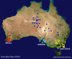
One of the most extreme examples was when Cobar in NSW was used to adjust the records at Alice Springs –almost 1500km away (h/t Bill Johnston). That adjustment was 0.6°C down in 1932 (due to a site move, we’re told). This potentially matters to larger trends because Alice Springs is a long running remote station — the BOM itself says that Alice Springs alone contributes about 7-10 % of the national climate signal.[1] Curiously Cobar itself was adjusted in 1923 by a suite of ten stations including Bendigo Prison which is another 560 km farther south in a climate zone pretty close to Melbourne. In 1923 Cobar official temperatures were adjusted down by a significant 1.3 °C. No reason is given for this large shift — a shift larger than the entire (supposed) effect of CO2 in the last hundred years.

LIST OF HISTORICAL TEMPERATURE EXTREMES BY U.S. STATE SHOWS NO SIGN OF GLOBAL WARMING

by Cap Allon, Oct 10, 2020 in Electroverse


Below I’ve compiled a list of the hottest and coldest temperatures ever recorded in each U.S. state, according to NOAA data. Surely, if catastrophic global warming was actually a thing then it would show up in the temperature records. Spoiler: it doesn’t, and a discussion on why follows the list.

ALABAMA

– All-time highest temperature: 112° F (Centreville on Sept. 6, 1925)

– All-time lowest temperature: -27° F (New Market 2 on Jan. 30, 1966)

ALASKA

– All-time highest temperature: 100° F (Fort Yukon on June 27, 1915)

– All-time lowest temperature: -80° F (Prospect Creek on Jan. 23, 1971)

ARIZONA

– All-time highest temperature: 128° F (Lake Havasu City on June 29, 1994)

– All-time lowest temperature: -40° F (Hawley Lake on Jan. 7, 1971)

ARKANSAS

All-time highest temperature: 120° F (Ozark on Aug.10, 1936)

– All-time lowest temperature: -29° F (Gravette on Feb.13, 1905)

CALIFORNIA

– All-time highest temperature: 134° F (Greenland Ranch on July 10, 1913)


WISCONSIN

– All-time highest temperature: 114° F (Wisconsin Dells on July 13, 1936)

– All-time lowest temperature: -55° F (Couderay 7 W on Feb. 4, 1996)

WYOMING

– All-time highest temperature: 115° F (Basin on Aug. 8, 1983)

– All-time lowest temperature: -66° F (Riverside Ranger Station, Yellowstone National Park) on Feb. 9, 1933)

More than 210 degrees Fahrenheit separates the highest and the lowest temperatures on record in the United States, and it isn’t a coincidence that the majority of these temperatures records –for both hot and cold– occur during solar minimums.

This is because low solar activity weakens the jet stream, reverting its usual tight ZONAL flow to more of a wavy MERIDIONAL one. This violent “buckling” effect FULLY explains how regions can experience pockets of anomalous heat while others, even relatively nearby, can be dealing with blobs of record cold: basically, in the NH, Arctic cold is dragged anomalously far south and Tropical warmth is pushed unusually far north (for more see the two links below)