by Cap Allon, April 16, 2020 in ClimateChangeDispatch
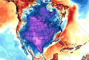
Record cold and snowfall hit many parts of North America over the Easter weekend, continuing what has so far been a largely Arctic April.
Records were toppled across many U.S. states, with Montana, Iowa, South Dakota, and Colorado seemingly worst hit.
A winter storm system moved through Iowa on Sunday delivering between three inches and a foot to the majority of locations — several northern Iowa towns saw all-time records tumble:
The 3.7 inches that fell at Sioux Gateway Airport broke the record for April 12th; it also made it the second-highest Easter snowfall ever behind the 4.7 inches during Easter 1929.
The town of Ringsted in Emmet County (also Iowa) came in with a record-busting 11 inches.
Robert “Lightning” Petersen was the man to log the accumulation — he uses his back yard measuring equipment to keep track of snow and rainfall. He works in concert with the National Weather Service out of Johnston.
…
by Cap Allon, October 11, 2019 in Electroverse
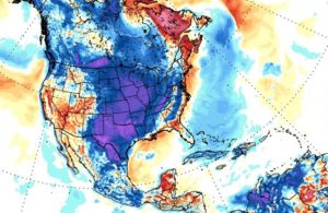
The Grand Solar Minimum has set in across British Columbia, Canada’s westernmost province.
According to Environment Canada, at least 41 all-time low temperature records were busted between Oct 9th and Oct 10th in BC, with more expected to fall as cold air lingers into the weekend.
A meridional jet stream flow, associated with low solar activity, has been diverting masses of Arctic air into the lower latitudes of late. North America is currently taking the brunt, with many central regions now suffering their second HISTORIC SNOWSTORM in as many weeks:
…
by Cap Allon, October 3, 2019 in Electroverse
This weekend will mark the final phase of a major winter storm that ravaged the NW U.S. bringing whipping winds to the Flathead Valley, feet of snow along the Continental Divide and record-breaking/challenging temps for all.
A new all-time daily record low temperature was set in Kalispell, Montana on Wednesday, October 02 as the mercury plunged into the teens across the region.
The weather station at Glacier Park International Airport recorded a low of 19F (-7.2C) at 5 AM which busted the dates previous record low of 21F (-6.1C) set back in 1999.
Great Falls, Montana registered a record-smashing 9F (-12.8C) on Tue, Oct 01, according to the NWS, which annihilated the previous daily low of 22F (-5.6C) set back in 1959.
Additionally, areas to the northwest also saw record low daily temperatures on Tuesday as both Cut Bank and Browning comfortably surpassed their previous cold records from 1950.
And further south, crossing a few state lines into California, temperatures at Sacramento Executive Airport dropped to 42F (5.6C) early Wednesday morning, surpassing the old record of 43F (6.1C) set in 1971. Meaning that in less than a week, Sacramento has now set multiple all-time record lows; on Sunday, both downtown Sacramento and the airport set record lows of 45F (7.2C) and 46F (7.8C) respectively.
…
…
by Cap Alon, July 26, 2019 in Electroverse
Lima, the capital of Peru, is going through one of its coldest winters in almost 50 years, according to the National Service of Meteorology and Hydrology, with this year even surpassing the truly brutal 2018 season.
“Lima is currently recording minimum temperatures around 14.7C,” said climatology expert Lourdes Menis Álvarez of Senamhi. “As for maximum temperatures, we are around 17.5C.”
Comparing these temperatures to the 2018 season, which itself was one of the coldest winters on record, Álvarez found that this year has been significantly cooler to date, with temps ranging on average between 1C to 1.5C colder.
According to Álvarez, these types of cold winters were once common-place in Lima. Of late, however, strong El Niños have brought “long summers and warm winters” to the region.
Though the tide is clearly now turning. Álvarez: “The winter of 2018 was one of the coldest in almost 50 years. However, the winter of 2019 has already surpassed it in intensity.”
The cold times are returning, in line with historically low solar activity:
…
See also here (Russia)
by P. Gosselin, February 10, 2019 in NoTricksZone
Charismatic Swiss meteorologist Jörg Kachelmann posted a comment at Twitterwhere he wondered what flagship German ZDF television was thinking when its evening news announced the polar vortex was some sort of new phenomenon arising from global warming.
Recently in the media we’ve been hearing a lot about the junk science that a warmer Arctic is somehow miraculously producing extreme cold over vast neighboring continents.
NOAA: “Polar vortex nothing new […] term appeared in 1853”
…
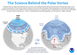
The science behind the polar vortex.(NOAA)Download
…
by Anthony Watts, January 31, 2019 in WUWT
There has been almost a death watch going on for Chicago, looking for an all time new all-time low temperature record to beat the previous -27°F. For those wishing for a new datapoint, Chicago didn’t beat the all time record, but did set a new record for the day…
…
by Roy Spencer, January 24, 2019 in WUWT
A “Siberian Express” weather disturbance currently crossing the Arctic Ocean will meet up with the semi-permanent winter “polar vortex” over Canada, pushing a record-breaking cold air mass into the Upper Plains and Midwest U.S. by Wednesday.
Chicago All-Time Record Low?
Both the European (ECMWF) and U.S. (GFS) weather forecast models are in agreement that by Wednesday morning temperatures in the Chicago suburbs will be approaching -30 deg. F. The all-time official record low for the Chicago metro area was -27 deg. F (O’Hare) on January 20, 1985, and that 34 year old record could fall as the ECMWF model is forecasting -32 deg. F for Thursday morning while the GFS model is bottoming out at -26 deg. F on Wednesday morning. Of course, these forecasts will change somewhat in the coming days as the cold wave approaches.
…
by Mo Mozuch, November 22, 2018 in Newsweek
Talk about cold turkey! The coldest Thanksgiving in 100 years, and quite possibly the coldest Thanksgiving ever, has hit the Northeast United States today.
The unprecedented cold snap comes courtesy of a large Canadian chill working its way across the country on its way to the Atlantic. According to the Weather Network, the deep freeze is the result of a large, low pressure system moving south from the Arctic across the Great Lakes. Combine that with a wicked wind chill, and many Americans are looking at the coldest Thanksgiving in a century.
…
by P. Gosselin, June 24, 2018 in NoTricksZone
Where’s the warming!
The Arctic and North Atlantic have suddenly turned surprisingly cold. First, according to Weatherbell meteorologist Joe Bastardi, the northern Atlantic has turned cold; so cold in fact that Bastardi called it “impressive”: …
All the Atlantic cold could have a big (positive) impact on the upcoming hurricane season, says hurricane expert Philip Klotzbach. One week ago Klotzbach tweeted …
by Princeton University, January 10, 2018 in A. Watts WUWT
Princeton University researchers have found that the climate models scientists use to project future conditions on our planet underestimate the cooling effect that clouds have on a daily — and even hourly — basis, particularly over land.
The researchers report in the journal Nature Communications Dec. 22 that models tend to factor in too much of the sun’s daily heat, which results in warmer, drier conditions than might actually occur. The researchers found that inaccuracies in accounting for the diurnal, or daily, cloud cycle did not seem to invalidate climate projections, but they did increase the margin of error for a crucial tool scientists use to understand how climate change will affect us.
by A Matthews and M Duell, November 29, 2017 in MailOnline
-
Widespread frost and snowfall is on the way with temperatures plummeting in London by this evening
-
Parts of Scotland could fall to -10C (14F), lower than the -8C forecast in Lapland and OC in St Petersburg
-
Met Office has issued ice warnings for northern Scotland and England with 2in inches of snow set to fall
-
Snow is also forecast for North East England tomorrow including up to 4in on the North York Moors
La géologie, une science plus que passionnante … et diverse
