Archives par mot-clé : Glaciers

No, CNN, Climate Change Is Not Driving Doomsday Glacier’s Decline

by S. Burnett, Mar 5, 2024 in ClimateChangeDispatch


A CNN story implies that supposed human-caused climate change is causing the Thwaites Glacier to melt, causing sea level rise. This is false.

Data show that Antarctica has not been warming. Also, the study CNN cited itself shows the glacier has declined dramatically and recovered repeatedly in the past, all without human contribution, suggesting the present decline is part of a natural cycle. [emphasis, links added]

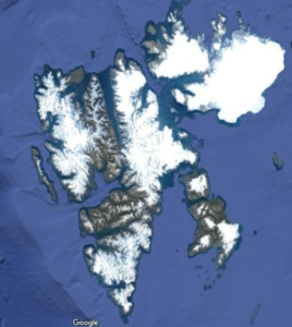
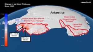
At approximately the size of Florida, the Thwaites Glacier is the broadest glacier on Earth. The Thwaites Glacier is often referred to as the “Doomsday Glacier,” based on the belief that a complete collapse would cause as much as two feet of sea level rise over time.

The CNN story, “The ‘Doomsday Glacier’ is rapidly melting. Scientists now have evidence for when it started and why,” discusses a new study published in the journal Proceedings of the National Academy of Sciences, which determined when the present decline began.

“By analyzing marine sediment cores extracted from beneath the ocean floor, researchers found the glacier began to significantly retreat in the 1940s, likely kicked off by a very strong El Niño event — a natural climate fluctuation which tends to have a warming impact,” reports CNN.

“Since then, the glacier has been unable to recover, which may reflect the increasing impact of human-caused global warming, according to the report.”

Although the commencement of … Thwaites’ decline may now have been determined, any prognostications about future trends for the glacier are pure speculation, unsupported by historical evidence or data about present Antarctic trend.

The underlying reports determined that the Thwaites glacier’s decline commenced in the 1940s probably prompted by a powerful El Nino event that warmed the abutting waters.

….

Mountain glacier melting is linked to shifting westerlies and likely to accelerate

by University of Maine, Dec 13, 2022 in ScienceDaily 


The combination of global atmospheric warming and westerly winds shifting toward the poles will likely speed up the recession of mountain glaciers in both hemispheres, according to a UMaine study.

Mountain glaciers freeze and gain mass when the climate cools, and melt and lose mass when the climate warms. The extent to which the fluctuations in mountain glaciers are reflective of local, regional and even hemispheric climate variations, however, is less clear, which has made it more difficult for scientists to use glacial data to interpret past climate dynamics and make predictions for the future.

A team of researchers from the University of Maine conducted a National Science Foundation-funded study evaluating how atmospheric conditions are reflected in the mass fluctuations of mid-latitude glaciers on opposite sides of the Earth, comparing global temperature and wind changes with glacier snowline elevations (also called “equilibrium-line altitudes”) in the Southern Alps of New Zealand and in the European Alps observed over the course of nearly four decades. Glacier extent is dependent on the height of the snowline in the atmosphere, below which ice melts, which in turn is determined by the temperature of the atmosphere.

The data showed that the fluctuations in glacial snowlines reflected temperature changes over large regions of the atmosphere for the two mountain systems studied — even on hemispheric scales. Moreover, the latitudes of westerly wind belts were found to be important for regulating the proportion of cold versus warm air masses that influence glacier melting and freezing.

Glacier saga

by J. Curry, Nov 10, 2022 in ClimateEtc.


The loss of glaciers from Glacier National Park is one of the most visible manifestations of climate change in the U.S.  Signs were posted all around the park, proclaiming that the glaciers would be gone by 2020.  In 2017, the Park started taking these signs down.  What happened, beyond the obvious fact that the glaciers hadn’t disappeared by 2020?

Screen Shot 2022-11-10 at 11.31.49 AM

Not only are Montana’s glaciers an important icon for global warming (e.g. Al Gore’s Inconvenient Truth), it also seems that the glaciers are an important political icon for progressive politicians in Montana. Earlier this week, Reilly Neill, a (sort of) politician in Montana, went after me on Twitter:

Scotland In the Little Ice Age

by P. Homewood, Nov 3, 2022 in WUWT


Dundee University geographer Dr Martin Kirkbride said a glacier may have survived in the Cairngorms as recently as the 18th Century.

Britain’s last masses of slow-moving ice and snow were understood to have melted 11,500 years ago.

Dr Kirkbride studied the formation of corries in the Cairngorms.

A corrie is a basin-shaped feature created by glaciations in the mountains.

Using a technique called cosmogenic 10Be dating, Dr Kirkbride showed that a small glacier in a Cairngorms corrie piled up granite boulders to form moraine ridges within the past few centuries, during the period of cool climate known as the Little Ice Age.

Dr Kirkbride said: “Our laboratory dating indicates that the moraines were formed within the last couple of thousand years, which shows that a Scottish glacier existed more recently than we had previously thought.

“The climate of the last few millennia was at its most severe between 1650 and 1790.

“There are some anecdotal reports from that time of snow covering some of the mountain tops year-round. What we have now is the scientific evidence that there was indeed a glacier.”

Dundee University said scientists had speculated that glaciers may have re-formed in the Highlands around the time of this Little Ice Age but hard evidence has proved to be elusive.

Dr Kirkbride teamed up with Dr Jez Everest at the British Geological Survey in Edinburgh, and the Cosmogenic Isotope Analysis Facility at the Scottish Universities Environmental Reactor Centre in East Kilbride, to carry out the research.

Arctic-Wide Glaciers And Ice Caps Were Absent Or Smaller Than Today From 10,000 To 3000 Years Ago By Kenneth Richard on 29. August 2022

by K. Richard, Aug 29, 2022 in NoTricksZone


A new study details how a much warmer climate than today led to the disappearance of glaciers and ice caps during the sub-300 ppm CO2 Early to Middle Holocene. The Arctic’s modern ice extent is among the largest of the last 10,000 years.

Glaciologists Larocca and Axford (2022) have synthesized a comprehensive record of Arctic-wide glaciers and ice caps (GICs) situated near lakes for Greenland, Alaska, Arctic Canada, Iceland, Scandinavia, Svalbard, and the Russian Arctic.

They compared the current volume and extent of GICs to past Holocene periods when they were either 1) smaller than present or 2) absent, with the latter characterizations signifying greater Arctic warmth.

..;

Contrary to the popular view that the modern glacier and ice cap extents are unprecedentedly small or on the verge of disappearing for the first time ever, the authors found more than half the Arctic’s GICs that exist today either did not exist or were smaller than today from 10,000 to 3400 years ago, when atmospheric CO2 ranged between 260 and 270 ppm.

Furthermore, most (“80% or more”) were smaller than today or absent from 7900 to 4500 years ago, which was the peak of this interglacial’s Arctic warmth – multiple degrees Celsius warmer than today.

The following images from the paper document the “Percent of GICs smaller or absent” for each region over the course of the last 10,000 years or more. Notice that between 80% to 100% of GICs were smaller than today or absent from about 8000 and 4000 years ago, and that even the Roman and Medieval Warm Periods had lower GICs extent than today.

The largest glacier and ice cap extent of the Holocene has been realized in the last millennium, suggesting any recession of GICs in the last few centuries is but a partial return to a former period of much greater warmth.

Impact of Changing Climate on Andean Glaciers in Sync with Polar Ice

by University of Florida, Jul 14, 2022 in WUWT


Peer-Reviewed Publication

Glaciers in tropical mountain ranges are experiencing similar impact from the drivers of climate change as those in the polar regions of Antarctica and the Northern Hemisphere, according to a study published today in Nature.

The paper by a team of international scientists, including Robert Hatfield, an assistant professor in the University of Florida Department of Geological Sciences, is the first to show that the effects of greenhouse gases and other drivers of the Earth’s temperature are impacting glaciers in the Southern Hemisphere at the same pacing as ice sheets in the north.  To derive their findings, researchers used sedimentary deposits from Lake Junín, high in the Peruvian Andes, to create a record of glacial changes stretching back 700,000 years.

Hatfield explained that much of what scientists knew about past glacial changes came from records of ice growth and decay that occurred in the Northern Hemisphere.

“As we try to understand how climate works across the globe, we need more than just records that are influenced by and biased toward the Northern Hemisphere,” Hatfield said.

The land-based lake record collected by Hatfield and his colleagues matches the duration of ice core records from Antarctica and spans the longest time frame ever collected from the Southern Hemisphere.

“What makes our findings unique is that we were able to get a continuous and independently dated record of tropical Alpine glaciation for the first time,” he said. “The key takeaway was that the tropics follow the same beat and same rhythm to what’s going on in the Northern Hemisphere.”

Despite variations in solar radiation between the two hemispheres, the study showed glacier changes in both regions occurred at the same time. This suggests that the rise in atmospheric greenhouse gas concentrations associated with changes in the volume of the ice sheets of the north is influencing the entire planet simultaneously.

The NOT melting glacier

by T. Ciccone & J. Lehr, May 31, 2022 in CFact

beautiful white icy hill with cave in antarctic


Could Antarctica’s ‘Doomsday Glacier’ meet its doom within 3 years?

Time is melting away for one of Antarctica’s biggest glaciers, and its rapid deterioration could end with the ice shelf’s complete collapse in just a few years,” alarmist researchers warned at a virtual press briefing on Dec. 13, 2021 at the annual meeting of the American Geophysical Union (AGU)–a once outstanding professional society, but now a shill for the left.

Above is the first sentence of the article titled Antarctica’s ‘Doomsday Glacier’ could meet its doom within 3 years,not what we would expect to see from a once reputable source, the AGU. It warns us that in a few years, the world’s largest glacier, about the size of Florida, will melt and raise ocean levels by up to 3 meters (about 10 ft). It then tells us that the glacier is melting from below because the surrounding ocean waters have been warmed thanks to human-induced climate change.Finally, it tells us that a team of more than 100 scientists from the USA and the UK have been studying the Thwaites glacier and sharing their findings with scientists worldwide.

The article then explains that the Thwaites is not melting from above, but the melting is coming from below,from the warmed-up oceans that have been warmed by human-made CO2 and the greenhouse effect. The bulk of the article then proceeds to detail the forecasted consequences around the world:

This team may not have even been communicating with each other. Almost a decade earlier, geologists were seeing evidence of volcanoes in a known active tectonic plate boundary, buried under the glacier and the oceans. Before 2017, at least 47 volcanoes were found in western Antarctica and around the area of the Thwaites glacier. In 2017 the Guardian reported that an additional 91 volcanoes had been found along the western shores of Antarctica, with some sitting under the Twaites glacier itself. See the article Scientists discover 91 volcanoes below Antarctic ice sheet.

Holocene ice-free strait followed by dynamic Neoglacial fluctuations: Hornsund, Svalbard

by A. Osaka et al., Apr 25, 2022 in TheHolocene


Keywords

The recession of the Hornbreen-Hambergbreen glaciers (Hornsund, Svalbard) will lead to the formation of a strait between the Greenland and Barents Seas within a few decades. We provide evidence for the earlier existence of this strait, in the Early–Middle Holocene and presumably since 1.3 ka cal. BP until glacier advance 0.7 ± 0.3 ka or earlier. Radiocarbon dating of mollusc shells from the ground moraines in the Hornbreen forefield indicate the existence of the marine environment at the contemporary glacierized head of Hornsund since 10.9 ka cal. BP or earlier due to glacier retreat. The gap in the radiocarbon dates between 3.9 and 1.3 ka cal. BP and the published results of 10Be exposure dating on Treskelen suggest the strait’s closure after glacier advance in the Neoglacial. Subsequent re-opening occurred around 1.3 ka cal. BP, but according to 10Be dates from Treskelen, the strait has again been closed since ca. 0.7 ± 0.3 ka or earlier. The oldest known surge of Hornbreen occurred around 1900. Analysis of Landsat satellite images, morphometric indicators characterizing the glacier frontal zones and previous studies indicate one surge of Hambergbreen (1957–1968) and five re-advances of Hornbreen in the 20th century (after 1936, between 1958 and 1962, in 1986–1990, 1998–1999, 2011). While the warmer Holocene intervals might be a benchmark for the effects of future climate change, glacier dynamics in post-Little Ice Age climate warming seems to be an analogue of glacier retreats and re-advances in the earlier periods of the Holocene.

A Potted History of Glaciers

by P. Homewood, Nov 10, 2021 in NotaLotofPeopleKnowThat


A friend recently suggested that “melting glaciers” must surely prove “global warming is true”.

It is a common belief. After all, glaciers are a visible phenomenon and it all sounds logical.

As you know, I have written extensively about glaciers, (see the “glaciers” tab on the sidebar). But it is worth posting this potted history of them:

Summary

The modern day retreat of glaciers is part of a much longer natural cycle. Indeed, we find evidence of that cycle going back long before the Middle Ages.

Lamb, for instance, claims that glaciers in the Alps and Norway were advancing between 800 and 400BC, reaching an extent almost as great as during the Little Ice Age. They advanced again around AD600 to a similar position as before.

In between times, of course, the same glaciers also retreated, both during the Roman Warm Period and the Medieval Warming Period.

Whether man-made warming has played any part in modern glacial retreat, we know that:

  • Most of the retreat since the 18thC occurred before any possible impact from humans.
  • Glaciers were smaller than now in the Middle Ages
  • There is nothing unprecedented or alarming about the current state of the world’s glaciers

All of this is common knowledge amongst glaciologists. But for some reason the world of climate science does not want the public to know.

19th century glacier retreat in the Alps preceded the emergence of industrial black carbon deposition on high-alpine glaciers

by M. Sigl et al., Jan 8, 2018 in TheCryosphere


Starting around AD 1860, many glaciers in the European Alps began to retreat from their maximum mid-19th century terminus positions, thereby visualizing the end of the Little Ice Age in Europe. Radiative forcing by increasing deposition of industrial black carbon to snow has been suggested as the main driver of the abrupt glacier retreats in the Alps. The basis for this hypothesis was model simulations using elemental carbon concentrations at low temporal resolution from two ice cores in the Alps.

Here we present sub-annually resolved concentration records of refractory black carbon (rBC; using soot photometry) as well as distinctive tracers for mineral dust, biomass burning and industrial pollution from the Colle Gnifetti ice core in the Alps from AD 1741 to 2015. These records allow precise assessment of a potential relation between the timing of observed acceleration of glacier melt in the mid-19th century with an increase of rBC deposition on the glacier caused by the industrialization of Western Europe. Our study reveals that in AD 1875, the time when rBC ice-core concentrations started to significantly increase, the majority of Alpine glaciers had already experienced more than 80 % of their total 19th century length reduction, casting doubt on a leading role for soot in terminating of the Little Ice Age. Attribution of glacial retreat requires expansion of the spatial network and sampling density of high alpine ice cores to balance potential biasing effects arising from transport, deposition, and snow conservation in individual ice-core records.

Long Term Changes on the Grindelwald Glacier

by P. Homewood, March 28, 2021 in IowaClimSciEducation


The Upper & Lower Grindelwald Glaciers in 1774 by Caspar Wolf

https://en.wikipedia.org/wiki/Caspar_Wolf

HH Lamb’s Climate, History and The Modern World tells us much about the history of Alpine glaciers. For instance, how they advanced rapidly between 800 and 400 BC. They then retreated before advancing again between AD 600 and AD 850, when they may have even reached Little Ice Age maximum extents.

We are probably all familiar with the terrifying glacier advances, which began in the 17thC, following centuries of a much warmer climate. These were catastrophic for anybody living nearby, as farming land was wiped out, and even the land that escaped being overrun was far too cold to farm. As a result, famine was rife in Switzerland and elsewhere, even in cities which relied on the countryside for food.

People living in those days would have been dumfounded to hear that there are some now who are worried that glaciers are getting smaller.


A paper by Zumbuhl et al, published in 2006, offers a detailed history of the Lower Grindelwald glacier, as well as the Mer de Glace in the Mont Blanc region:

Claim: Melting glaciers contribute to Alaska earthquakes

by UNIVERSITY OF ALASKA FAIRBANKS, March 15, 2021 in WUWT


In 1958, a magnitude 7.8 earthquake triggered a rockslide into Southeast Alaska’s Lituya Bay, creating a tsunami that ran 1,700 feet up a mountainside before racing out to sea.

Researchers now think the region’s widespread loss of glacier ice helped set the stage for the quake.

In a recently published research article, scientists with the University of Alaska Fairbanks Geophysical Institute found that ice loss near Glacier Bay National Park has influenced the timing and location of earthquakes with a magnitude of 5.0 or greater in the area during the past century.

Scientists have known for decades that melting glaciers have caused earthquakes in otherwise tectonically stable regions, such as Canada’s interior and Scandinavia. In Alaska, this pattern has been harder to detect, as earthquakes are common in the southern part of the state.

Alaska has some of the world’s largest glaciers, which can be thousands of feet thick and cover hundreds of square miles. The ice’s weight causes the land beneath it to sink, and, when a glacier melts, the ground springs back like a sponge.

“There are two components to the uplift,” said Chris Rollins, the study’s lead author who conducted the research while at the Geophysical Institute. “There’s what’s called the ‘elastic effect,’ which is when the earth instantly springs back up after an ice mass is removed. Then there’s the prolonged effect from the mantle flowing back upwards under the vacated space.”

In the study, researchers link the expanding movement of the mantle with large earthquakes across Southeast Alaska, where glaciers have been melting for over 200 years. More than 1,200 cubic miles of ice have been lost.

Southern Alaska sits at the boundary between the continental North American plate and the Pacific Plate. They grind past each other at about two inches per year — roughly twice the rate of the San Andreas fault in California — resulting in frequent earthquakes.

….

Studies Show Glaciers Worldwide Were Smaller Than Today

by Die Late Sonne, Feb 26, 2021 in ClimateChangeDispatch


Former Iceland Prime Minister fed up with climate tourism: Glaciers used to be smaller than today

By Die kalte Sonne
[German text translated by P. Gosselin]

Many glaciers are currently shrinking, as they have always done in the past when the climate warmed up. What’s the news on the glacier front?

In August 2019, the Okjokull Glacier disappeared in Iceland with great media attention. The BBC reported:

Climate change: Iceland holds funeral for melted glacier

The glacier called Okjokull is the first in the country to be lost to climate change, after the warmest July ever on record. Iceland loses about 11 billion tonnes of ice per year, and scientists have warned that there are about 400 other glaciers also at risk. They fear all of the island’s glaciers will be gone by 2200. Glaciers cover about 11% of Iceland’s surface.”

Read more at the BBC.

However, the glacier had not formed until the Little Ice Age. See our article “The cycle is full: the death of an Icelandic glacier that did not exist even during the Medieval Warm Period“. Iceland’s prime minister from 2013-2016, David Gunnlaugsson, dislikes activism. In The Spectator, Gunnlaugsson wrote on November 23, 2019:

Iceland’s melting glaciers are nothing to panic about

Ocean forcing drives glacier retreat in Greenland

by M. Wood et al., Jan 01, 2021 in AAAS OPEN ACCESS


INTRODUCTION

The Greenland Ice Sheet has contributed substantially to sea-level rise over the past few decades. Since 1972, approximately two-thirds of the ice sheet’s contribution to sea-level rise resulted from increased glacier flux with the remaining one-third from anomalous surface melt (1). Before 2000, anomalous ice discharge was the dominant driver of mass loss, but in recent years, increasingly negative surface mass balance anomalies have contributed to a larger proportion of the total mass loss from the ice sheet (1). The acceleration in mass flux has been partially attributed to a warming of subsurface waters around Greenland near the end of the 1990s (2, 3) and increased runoff, resulting in enhanced water mixing and melt at glacier margins, destabilization of terminus regions (4, 5), ice front retreat (6, 7), and, in most cases, accelerated ice flow (8). The increase in flow speed, combined with enhanced surface melt, results in increased glacier thinning, which is conducive to further retreat (9). Other processes may have additionally contributed to the glacier retreat, e.g., increases in basal lubrication, melting of the ice mélange in front of glaciers, or weakening of glacier shear margins, but quantitative evidence about their impact has been limited (1012).

The warming of subsurface waters at the turn of the 21st century was caused by the spreading of ocean heat from the subpolar gyre during a transition in the North Atlantic Oscillation (NAO) from a high positive phase to a low-to-negative phase (3). In this shift, the North Atlantic subpolar gyre expanded, enhancing ocean heat fluxes through the coastal Irminger and West Greenland currents, yielding warmer subsurface waters on the continental shelf of all seven major basins of Greenland (Fig. 1). Since 2010, the NAO has transitioned back to a more positive phase, yielding a relative cooling of the ocean waters, however, not sufficiently to bring back ocean heat fluxes to the levels of the 1990s (13).

Claim: Svalbard glaciers lost their protective buffer in the mid-1980s and have been melting ever since

by B. Noel & M.  van den Broeke, Sep  23, 2020 in WUWT/U.Utrecht


The archipelago of Svalbard, a land of ice and polar bears, is found midway between mainland Norway and the North Pole. Its capital Longyearbyen on the main island of Spitsbergen is the world’s most northerly city, some 800 miles inside the Arctic Circle.

Svalbard is also home to some of the Earth’s northernmost glaciers, which bury most of the archipelago’s surface under no less than 200 metres of thick ice. Taken together, Svalbard glaciers represent 6% of the worldwide glacier area outside the large ice sheets of Greenland and Antarctica – if they totally melted, they would raise the sea level by 1.7cm.

Svalbard is roughly the size of Ireland or Sri Lanka, but largely covered in ice. Google Maps

Large Increase In Number Of Sunshine Hours Likely Behind Warming, Glacier Retreat In Alps Since 1980

by P. Gosselin, August 9, 2020 in NoTricksZone

Today global warming alarmists insist blaming climate change on man-made CO2 emissions. Yet, everywhere we look it’s difficult to find any correlation between CO2 and warming. Pre-industrial history shows that changes in CO2 in fact followed temperature changes.

Today we look at some climate charts of the European upper Ostalpen to look for hints what may be behind the warming since the late 20th century. We know glaciers there have been receding over the recent decades.

First is a mean temperature chart of the region for the May to September period going back 133 years:


Chart cropped from video “Die Alpengletscher im Klimawandel: Status quo“, by Günther Aigner


More Proof That Geologic Forces Are Melting Thwaites and Pine Island Glaciers

by J.E. Kamis, July 20, 2020 in ClimateChangeDispatch


As previously explained before, increased melting/ice loss of Antarctica’s Pine Island and Thwaites glaciers is the result of geologically induced heat flow emitted from underlying bedrock “hotspots,” not climate change (Figure 1).

All but a very minor amount of Antarctica’s glacial ice melting occurs in the western portion of this continent. The most rapid and greatest ice mass loss areas are in West Antarctica.

They are positioned directly above geographically extensive and high heat flow geological features. This association is thought to be strong evidence of a cause and effect relationship.

Discussion of evidence supporting the contention that the melting of Pine Island and Thwaites glaciers is the result of bedrock heat flow begins with a review of the regional geology (refer to Figure 1).

The Pluton Rich “hotspot” is a 61,000-thousand-square-mile area that is home to numerous high-heat-flow lava pockets that are bounded and fueled by deep earth reaching faults.

Several detailed research studies document the existence and configuration of this area. This lies along the West Antarctic Rift.

The Mount Erebus Volcanic Complex “Hotspot” is the most geologically active portion of Antarctica. It is a 25,000-square-mile high-heat-flow area, much of which is absent of glacial ice.

The absence of glacial ice across a huge portion of West Antarctica is extremely unusual and exceedingly difficult to explain by invoking global warming.

Figure 1. NASA map of Antarctica’s ice sheet thickness 1992-2017. Greatest ice thickness losses shaded red. The outline of three regional sub-glacial geological Hotspots” are outlined in red (Image by NASA, most labeling by J. Kamis).

Editorial: Climate Impacts on Glaciers and Biosphere in Fuego-Patagonia

by C. Schneider et al., April 2020 in FrontierEarthScience


The regional climate in Southernmost South America is heavily influenced by the proximity to the oceans. This generates rather weak seasonal cycles with cool to cold summers and moderate to cold winters, especially on the western Pacific side. Slightly more pronounced, continental seasonal cycles are observed in the East of the Andes. While annual mean air temperatures across the region are decreasing from North to South precipitation patterns show very pronounced east-west gradients. The distinctive gradients in precipitation are caused by the north-south striking mountain ranges of the Patagonian Andes, and the northwest-southeast stretching mountain chains of the Cordillera Darwin. Both mountain ranges enforce heavy precipitation on the west and southwest exposed flanks by uplift and dry foehn-like conditions on the leesides (e.g., Holmlund and Fuenzalida, 1995; Schneider et al., 2003; Rasmussen et al., 2007) which produces extremely high drying ratios (Escobar et al., 1992; Carrasco et al., 2002; Smith and Evans, 2007). At inter-annual to decadal time scales atmospheric teleconnections such as the El Niño Southern Oscillation (ENSO) (Schneider and Gies, 2004), Southern Annular Mode (SAM), and Pacific Decadal Oscillation (PDO) are influencing spatial and temporal patterns of both, precipitation and air temperature. For example, positive SAM modes (Garreaud, 2009; Weidemann, Sauter, Kilian et al.) and the PDO (Villalba et al., 2003) are associated with higher air temperatures. Langhamer et al. show that the source of precipitation in the Southern Andes also depends on these teleconnections.

An important aspect is that Patagonia and Tierra del Fuego, together with the sub-Antarctic islands are the only regions where direct proximity between Antarctica and land masses north of the Southern Ocean is given. Such linkages are for example explored with investigations by Hebel et al. on the biosphere and Oppedal et al. for the regional glacier history.

Melting Glaciers Uncover Medieval Artefacts In Norway

by P. Homewood, April 16, 2020 in NotaLotofPeopleKnowThat


Melting glaciers in Norway have revealed ancient artefacts dropped by the side of a road more than 1,000 years ago.

Clothes, tools, equipment and animal bone have been found by a team at a lost mountain pass at Lendbreen in Norway’s mountainous region.

A haul of more than 100 artefacts at the site includes horseshoes, a wooden whisk, a walking stick, a wooden needle, a mitten and a small iron knife.

The team also found the frozen skull of an unlucky horse used to carry loads that did not make it over the ice.

The objects that were contained in ice reveal that the pass was used in the Iron Age, from around AD 300 until the 14th century.

Activity on the pass peaked around AD 1000 and declined after the black death in the 1300s, due as well to economic and climate factors.

The researchers say the melting of mountain glaciers due to climate change has revealed the historical objects, with many more to come.

https://www.dailymail.co.uk/sciencetech/article-8224817/Melting-ice-reveals-lost-Viking-mountain-path.html


Unfortunately neither the journalist nor the scientists seem to be capable of adding 2+2!


The existence of the Medieval Warm Period in Norway, followed by glacial advance in the Little Ice Age has been long known about, as HH Lamb wrote in 1982:

Denman Glacier–Latest Antarctic Meltdown Scare

by P. Homewood, March 24, 2020 in NotaLotofPeopleKnowThat


Scientists have found a new point of major vulnerability in the Antarctic ice sheet, in a region that already appears to be changing as the climate warms and has the potential to raise sea levels by nearly five feet over the long term.

Denman glacier, in East Antarctica, is a 12-mile-wide stream of ice that flows over the deepest undersea canyon in the entire ice sheet before spilling out into the ocean. That subsea trough is more than 2 miles deep, or double the average depth of the Grand Canyon. While there are far deeper trenches in the open ocean, such as the Marianas Trench, in this case the extreme undersea topography lies right on the outer fringe of the Antarctic continent — making it the “deepest continental point on Earth.”

In reality the scientists who wrote this study do not have a clue whether the retreat of the Denman is anything new or not, or whether the deep ocean temperatures are any warmer than before 1979. Or whether what they are observing is just a natural process.


We can then go on to explore sea level implications.

They claim that since 1979, 250 billion tonnes of ice has been lost, equivalent to 0.5mm of sea level rise. In other words, 1.3mm/C, hardly cataclysmic.

They then go on to talk about a potential loss of 540 trillion tonnes, raising sea levels by 5 feet. Yet at current rates, it would take 86400 years for this to occur!

As always with these sort of studies, the authors refuse to say how long all this will take to happen.


Studies Show Glaciers Worldwide Were Smaller Than Today

by Die Kalte Sonne & P. Gosselin, February 26, 2020 in ClimateChangeDispatch


19th century glacier retreat in the Alps preceded the emergence of industrial black carbon deposition on high-alpine glaciers

Light absorbing aerosols in the atmosphere and cryosphere play an important role in the climate system. Their presence in ambient air and snow changes the radiative properties of these systems, thus contributing to increased atmospheric warming and snowmelt. High Spatio-temporal variability of aerosol concentrations and a shortage of long-term observations contribute to large uncertainties in properly assigning the climate effects of aerosols through time.

Starting around AD 1860, many glaciers in the European Alps began to retreat from their maximum mid-19th century terminus positions, thereby visualizing the end of the Little Ice Age in Europe. Radiative forcing by increasing deposition of industrial black carbon to snow has been suggested as the main driver of the abrupt glacier retreats in the Alps. The basis for this hypothesis was model simulations using elemental carbon concentrations at low temporal resolution from two ice cores in the Alps.

Here we present sub-annually resolved concentration records of refractory black carbon (rBC; using soot photometry) as well as distinctive tracers for mineral dust, biomass burning and industrial pollution from the Colle Gnifetti ice core in the Alps from AD 1741 to 2015. These records allow precise assessment of a potential relation between the timing of observed acceleration of glacier melt in the mid-19th century with an increase of rBC deposition on the glacier caused by the industrialization of Western Europe. Our study reveals that in AD 1875, the time when rBC ice-core concentrations started to significantly increase, the majority of Alpine glaciers had already experienced more than 80 % of their total 19th-century length reduction, casting doubt on a leading role for soot in terminating of the Little Ice Age. Attribution of glacial retreat requires expansion of the spatial network and sampling density of high alpine ice cores to balance potential biasing effects arising from transport, deposition, and snow conservation in individual ice-core records.”

Also, a glacier history of the Alps since the end of the last ice age was published in 2009 by Susan Ivy-Ochs and colleagues.

Between 10,500-3300 years before today, glaciers were mostly smaller than today and ended 200 meters above modern levels. The Alpine glaciers expanded during the cold period of migration and the Little Ice Age.

Want to know more about glacier history? Here’s the abstract:

New Study: Greenland’s Largest Glacier Has Rapidly Thickened Since 2016…Fueled By 1.5°C Regional Ocean Cooling

by K. Richard, February 17, 2020 in NoTricksZone


Greenland’s largest glacier (Jakobshavn) has quite abruptly thickened since 2016. The thickening has been so profound the ice elevations are nearly back to 2010-2011 levels. The nearby ocean has cooled ~1.5°C – a return to 1980s-era temperatures.

The world’s glaciers have not been following along with the CO2-driven catastrophic melting narrative.

Alaska

For example, in a study of 50 Alaskan glaciers for the warming period between 1972-2012, researchers (McNabb and Hock, 2014) found there was
“…no corresponding change in the number of glaciers retreating nor do we see corresponding acceleration of retreat rates. To the contrary, many glaciers in the region have advanced…”

Patterns of thinning of Antarctica’s biggest glacier are opposite to previously observed

by University of Bristol, January 27, 2020 in ScienceDaily


Using the latest satellite technology from the European Space Agency (ESA), scientists from the University of Bristol have been tracking patterns of mass loss from Pine Island — Antarctica’s largest glacier.

They found that the pattern of thinning is evolving in complex ways both in space and time with thinning rates now highest along the slow-flow margins of the glacier, while rates in the fast-flowing central trunk have decreased by about a factor of five since 2007. This is the opposite of what was observed prior to 2010.

Pine Island has contributed more to sea level rise over the past four decades than any other glacier in Antarctica, and as a consequence has become one of its most intensively and extensively investigated ice stream systems.

However, different model projections of future mass loss give conflicting results; some suggesting mass loss could dramatically increase over the next few decades, resulting in a rapidly growing contribution to sea level, while others indicate a more moderate response.

Identifying which is the more likely behaviour is important for understanding future sea level rise and how this vulnerable part of Antarctica is going to evolve over the coming decades.

The results of the new study, published in the journal Nature Geoscience, suggest that rapid migration of the grounding line, the place where the grounded ice first meets the ocean, is unlikely over that timescale, without a major change in ocean forcing. Instead, the results support model simulations that imply that the glacier will continue to lose mass but not at much greater rates than present.

Lead author Professor Jonathan Bamber from the University of Bristol’s School of Geographical Sciences, said: “This could seem like a ‘good news story’ but it’s important to remember that we still expect this glacier to continue to lose mass in the future and for that trend to increase over time, just not quite as fast as some model simulations suggested.

“It’s really important to understand why the models are producing different behaviour in the future and to get a better handle on how the glacier will evolve with the benefit of these new observations.

“In our study, we didn’t make projections but with the aid of these new data we can improve model projections for this part of Antarctica.”

World Leading Alps Glaciologist Shows “Today’s Climate, Vegetation And Glacier Situation Nothing Special”

by H.J. Lüdecke & K.E. Puls, January 25, 2020 in NoTricksZone


Prof. Gernot Patzelt is an internationally renowned glaciologist with numerous publications and lectures. Now he has, as it were, presented his life’s work with the book “Gletscher: Klimazeugen von der Eiszeit bis zur Gegenwart“ (Glaciers: Climate Witnesses from the Ice Age to the Present” (Hatje Cantz-Verlag, Berlin, 2019, 266 pages). It combines the overwhelming artistic aesthetics of Alpine glaciers in painting with scientific glaciology.

Gernot Patzelt, Professor of High Altitude Research at the University of Innsbruck and Head of the Alpine Research Centre Obergurgl in Tyrol, was not and is not retired after his retirement in 2004. His lectures, especially those at EIKE climate conferences (here, here) and his writings, which are listed here, bear witness to this. He was also co-author of the book “A. Fischer und G. Patzelt: Gletscher im Wandel: 125 Jahre Gletscher-Meßdienst des Alpenvereins, Springer, 2018″.

His book “Klimazeugen von der Eiszeit bis zur Gegenwart” (Climate Witnesses from the Ice Age to the Present), which is discussed here, breaks new ground by making the otherwise rarely attempted connection between natural aesthetics and scientific description. The Austrian glaciologist  has convincingly succeeded in this attempt, namely the connection of painting history with Ice Age history, glacier history, landscape history, vegetation history, climate history, cultural history … and more!