Archives par mot-clé : Ice

Arctic Sea Ice Extent Higher Than 2006

by P. Homewood, April 6, 2021 in NotaLotofPeopleKnowThat


Seventh lowest? The NSIDC would of course like you to believe that this is all part of a declining trend. In reality, since the sharp decline beginning in 2004, sea ice extent has gone up and down, but with little overall change. This year and last year, average March extent has actually been higher than in 2006.

http://ocean.dmi.dk/arctic/icecover_30y.uk.php


This March, extent was the 8th highest in the last 18 years, putting it around the median.

What about prior to 2004 though? Should we not be comparing this year with the 1981-2010 average?

Like it or not, and whatever the reason, the loss of summer ice in 2007 has had a direct effect on sea ice at all times of year since. Much of the sea ice is now thin, new ice, which melts more readily in summer. Consequently, winter ice takes longer to form as well.

It would probably take a climatic regime shift, such as occurred in the 1960s, for ice to return to pre 2004 levels. But the evidence shows that winter sea ice extent is currently stable.


Antarctic Sea Ice Grows 2 Million Sq. Km – Area As Big As Saudi Arabia. And: Hamburg Spring Arriving Later…

by P. Gosselin, March 28 in NoTricksZone


Antarctic sea ice grows 2 million square kilometers in 4 years…

It’s hard to back up the statement: Global warming is global. Some places have seen warming over the past 40 years (e.g. Arctic), but other places have not.

Antarctica definitely has not been playing along with the man-made global warming hoax. (Yes, man has caused some of the warming, but not all – and it certainly isn’t catastrophic).

Antarctic sea ice surges

Though Antarctic sea ice fell to a “record minimum” in 2017 – after having reached a “record high” in 2015 – the latest data from the National Snow and Ice Data Centershow sea ice at the South Pole has bounced back robustly since, surging some 500,000 sq km above the mean.

On March 26, 2017, Antarctic sea ice measured 3.055 million sq km. Four years later, sea ice reached 5.103 million sq km. That’s a difference of more than 2 million sq. km., which is an area the size of Saudi Arabia!

No way to ignore natural factors

So why would sea ice grow so quickly? If the ice had disappeared, many would blame it on greenhouse gases – absurd of course. And it would be just as absurd to blame the recent gain on global cooling. Obviously there is a complex array of natural factors at work – factors that climate alarmists consistently have ignored over the past decades.

Here’s the March 26, 2021 satellite photo of Antarctica:

Source: NSIDC

Danish Institute Data: Greenland Ice Melt Has Slowed Down Significantly Over Past Decade

by P. Gosselin, March 10, 2021 in NoTricksZone


The media and activists, among them a number of “Climate scientists”, have been declaring that Greenland ice melt has been accelerating.

Today the German Klimaschau climate news video reports, however, that this has not been the case over the recent years. All the recent talk about accelerating Greenland ice loss over the past years is false.

SMB on the rise

First a plot of Greenland’s surface mass balance SMB (blue curve below) shows that snow accumulation has occurred faster than snow and ice have melted over the past 35 years:

Chart: cropped from Klimaschau here

Though the annual SMB values declined from 1985 to 2012, the trend has rebounded since.

Loss through coastal discharge steady over the past 15 years

ANTARCTICA SUFFERING COLDEST JANUARY SINCE 1978 + GLOBAL SEA ICE GROWING EXPONENTIALLY

by Cap Allon, Jan 29, 2021 in Electroverse


The start of 2021 in Antarctica has been an unusually chilly one. In fact, the first half of January has been the coldest since 1978, according to data compiled by @LpdlcRamirez and @peikko763 on Twitter.

As of Jan. 19, the month-to-date temperature anomaly across Antarctic is approx. -0.5C, making this the continents coldest first 3-or-so-weeks of Jan. since 1978 (solar minimum of cycle 20), according to research conducted by @peikko163 on Twitter, who also notes that the Southern Hemisphere as a whole is suffering anomalous January chills not seen since 2012.

But this chill of solar minimum isn’t just confined to the Southern Hemisphere either, the mercury ACROSS the planet is tumbling. In one month global temperatures dropped by a whopping 0.26C: from 0.53C above the 1981-2010 avg. in Nov. 2020 to just 0.27C above the avg. in Dec. 2020 (UAH). This drop was in spite of a warming Arctic–a region expected to “heat” during times of otherwise “global” cooling (more on that below).

The Sun appears to be sliding into its next Grand Solar Minimum cycle–a multidecadal spell of reduced solar output where the solar disc can be devoid of sunspots for months or even years at a time. The result on Earth’s climate will be one of violent swings between extremes due to a weakening of the jet streams: intense bursts of heat will linger in one area, while a teeth-chattering chill will dominate nearby, and then the regions will “switch” — it is this unpredictable chopping and changing that will hasten the failure of our modern food production systems: crops will fail, on a large scale, and famine could quickly ensue.

Overall, Earth’s temperature trends colder during a Grand Solar Minimum, as the Sun’s output sinks lower and lower (increased cloud nucleation being one likely forcing). However, not ALL regions experience the chill: as with the previous GSM (the Maunder Minimum 1645-1715), areas such as the Arctic, Alaska, and S. Greenland/N. Atlantic actually warmed while the rest of the planet cooled — NASA reveals the phenomenon in their Maunder Minimum temperature reconstruction map:

Ocean forcing drives glacier retreat in Greenland

by M. Wood et al., Jan 01, 2021 in AAAS OPEN ACCESS


INTRODUCTION

The Greenland Ice Sheet has contributed substantially to sea-level rise over the past few decades. Since 1972, approximately two-thirds of the ice sheet’s contribution to sea-level rise resulted from increased glacier flux with the remaining one-third from anomalous surface melt (1). Before 2000, anomalous ice discharge was the dominant driver of mass loss, but in recent years, increasingly negative surface mass balance anomalies have contributed to a larger proportion of the total mass loss from the ice sheet (1). The acceleration in mass flux has been partially attributed to a warming of subsurface waters around Greenland near the end of the 1990s (2, 3) and increased runoff, resulting in enhanced water mixing and melt at glacier margins, destabilization of terminus regions (4, 5), ice front retreat (6, 7), and, in most cases, accelerated ice flow (8). The increase in flow speed, combined with enhanced surface melt, results in increased glacier thinning, which is conducive to further retreat (9). Other processes may have additionally contributed to the glacier retreat, e.g., increases in basal lubrication, melting of the ice mélange in front of glaciers, or weakening of glacier shear margins, but quantitative evidence about their impact has been limited (1012).

The warming of subsurface waters at the turn of the 21st century was caused by the spreading of ocean heat from the subpolar gyre during a transition in the North Atlantic Oscillation (NAO) from a high positive phase to a low-to-negative phase (3). In this shift, the North Atlantic subpolar gyre expanded, enhancing ocean heat fluxes through the coastal Irminger and West Greenland currents, yielding warmer subsurface waters on the continental shelf of all seven major basins of Greenland (Fig. 1). Since 2010, the NAO has transitioned back to a more positive phase, yielding a relative cooling of the ocean waters, however, not sufficiently to bring back ocean heat fluxes to the levels of the 1990s (13).

Very Inconvenient Alps Glacier History…Top Glaciologists: Alps Were Ice-Free 6000 Years Ago

by C. Rotter, Jan 7, 2021 in WUWT


Alps ice-free…6000 years ago, when CO2 was much lower than today’s levels.

Dr. Sebastian Lüning earlier today released his latest Klimaschau report, No. 6. In the first part he looks at glaciers in the Alps over the course of much the Holocene.

See the video

It turns out that Most of the Alps were ice-free 6000 years ago, glaciologists have discovered.

In his video, the German geologist presents a new paper authored by glaciologists Bohleber et al, 2020 of the Austrian Academy of Science. The Austrian-Swiss team discovered from ice cores that the 3500-meter high Weißseespitze summit was ice free 5900 years ago.

Much warmer in the early Holocene

Lüning next shows why the Alps were ice-free 6000 years ago by using a chart by Heiri et al 2015, which shows it was some 2°C warmer than today.

Possible 1,000-kilometer-long river running deep below Greenland’s ice sheet

by  Hokkaido University, Nov 12, 2020 in EurekaAlert


Computational models suggest that melting water originating in the deep interior of Greenland could flow the entire length of a subglacial valley and exit at Petermann Fjord, along the northern coast of the island. Updating ice sheet models with this open valley could provide additional insight for future climate change predictions.

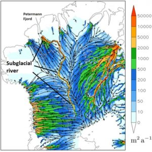
IMAGE: THE SUGGESTED VALLEY AND POSSIBLE RIVER FLOWING FROM THE DEEP INTERIOR OF GREENLAND TO PETERMANN FJORD DEEP BELOW GREENLAND’S ICE SHEET (500 METERS BELOW SEA LEVEL). (CHRISTOPHER CHAMBERS ET AL,… view more 

CREDIT: CHRISTOPHER CHAMBERS ET AL, THE CRYOSPHERE, NOVEMBER 12, 2020.

Radar surveys have previously mapped Greenland’s bedrock buried beneath two to three thousand meters of ice. Mathematical models were used to fill in the gaps in survey data and infer bedrock depths. The surveys revealed the long valley, but suggested it was segmented, preventing water from flowing freely through it. However, the peaks breaking the valley into segments only show up in areas where the mathematical modelling was used to fill in missing data, so could not be real.

Christopher Chambers and Ralf Greve, scientists at Hokkaido University’s Institute of Low Temperature Science, wanted to explore what might happen if the valley is open and melting increases at an area deep in Greenland’s interior known for melting. Collaborating with researchers at the University of Oslo, they ran numerous simulations to compare water dynamics in northern Greenland with and without valley segmentation.

The results, recently published in The Cryosphere, show a dramatic change in how water melting at the base of the ice sheet would flow, if the valley is indeed open. A distinct subglacial watercourse runs all the way from the melting site to Petermann Fjord, which is located more than 1,000 kilometers away on the northern coast of Greenland. The watercourse only appears when valley segmentation is removed; there are no other major changes to the landscape or water dynamics.

“The results are consistent with a long subglacial river,” Chambers says, “but considerable uncertainty remains. For example, we don’t know how much water, if any, is available to flow along the valley, and if it does indeed exit at Petermann Fjord or is refrozen, or escapes the valley, along the way.”

If water is flowing, the model suggests it could traverse the whole length of the valley because the valley is relatively flat, similar to a riverbed. This suggests no parts of the ice sheet form a physical blockade. The simulations also suggested that there was more water flow towards the fjord with a level valley base set at 500 meters below sea level than when set at 100 meters below. In addition, when melting is increased only in the deep interior at a known region of basal melting, the simulated discharge is increased down the entire length of the valley only when the valley is unblocked. This suggests that a quite finely tuned relationship between the valley form and overlying ice can allow a very long down-valley water pathway to develop.

“Additional radar surveys are needed to confirm the simulations are accurate,” says Greve, who has been developing the model used in the study, called Simulation Code for Polythermal Ice Sheets (SICOPOLIS). “This could introduce a fundamentally different hydrological system for the Greenland ice sheet. The correct simulation of such a long subglacial hydrological system could be important for accurate future ice sheet simulations under a changing climate.”

How to Scare and Deceive without Lying: JPL Cries Wolf about Polar Glacial Melt

by C. Beisner, Nov 6, 2020 in WUWT


Yesterday NASA’s Jet Propulsion Laboratory published “The Anatomy of Glacial Ice Loss.” For the most part it’s an interesting, though not particularly revolutionary, discussion of the various forces that add to and subtract from glacial ice. Nothing wrong with that.

But its authors took the opportunity to insert a poison pill, a little bit of fearmongering, in a video caption:

Did you catch that little trick? “Combined, the two regions also contain enough ice, that if it were to melt all at once, would raise sea levels by nearly 215 feet ….”

Well, yes, but at what rate is the ice from the two regions melting, and at what rate can we, with any confidence, predict they’ll continue to melt, and over what period of time?

There is absolutely no chance of their melting “all at once”—barring, I suppose, Earth’s collision with some enormous asteroid that sends Earth careening into the Sun!

So, how fast is the ice melting?

For Greenland, about 0.1% of its ice mass per decade—1 percent per century.

For Antarctica, about 0.0045% per decade—1% in 2,200 years.

Combined, those contribute to sea-level rise of about 1 mm per year, i.e., 3.94 inches per century.

(See “Lying with Statistics: The National Climate Assessment Falsely Hypes Ice Loss in Greenland and Antarctica.”)

So, if the actual rate is about 3.94 inches (0.3283 foot) per century, how long would it take to raise sea level by 215 feet? The answer: 215 ft. / 0.3283 ft. per century = 654.889 centuries, or 65,488.9 years.

3 More New Studies Show Modern Arctic Sea Ice Extent Is Greater Than Nearly Any Time In The Last 10,000 Years

by K. Richard, Oct 29, 2029 in NoTricksZone


For years scientists have been using biomarker evidence (IP25, PIP25) to reconstruct the Arctic’s sea ice history. The evidence shows modern (20th-21st century) Arctic sea ice is at its greatest extent since the Holocene began.

Scientists (Wu et al., 2020) have determined that from about 14,000 to 8,000 years ago, when CO2 lingered near 250 ppm, the Beaufort Sea (Arctic) was “nearly ice free throughout the year” (<0.2 PIP25) and ~4°C warmer than today in winter.

With CO2 at ~400 ppm, this region is 70-100% ice-covered (>0.8 PIP25) for all but 1-2 summer months in the modern (1988-2007) era.

….

“Where’s the sea ice?” Right where it’s been for most of the Holocene.

by D. Middleton, Oct 30, 2020 in WUWT


This is sort of a sequel yesterday’s post: Where’s the sea ice? 3 reasons the Arctic freeze is unseasonably late and why it matters.

What a difference a day can make! Looks like it’s starting to crust over:

Figure 0. Daily sea ice extent map, October 29, 2020. (NSIDC)

Two key takeaways:

  1. Maximum Holocene sea ice extent occurred within the past 500-1,000 years at every location.
  2. The current sea ice extent is higher at all of the locations than over 50% to 85% of the Holocene.

While this doesn’t tell us what the sea ice extent was in million km2, it does tell us that the modern sea ice extent is larger than it was over most of the Holocene Epoch. It also tells us that the areas of currently seasonal sea ice extent have been seasonal or reduced over most of the past 5,000 years and ice-free or nearly ice-free over the prior 3,000 years or so. Here’s is the Kinnard graph plotted at the same horizontal scale as the Stein cross section:

NSIDC: 2020 POLAR ICE DOING JUST FINE

by Cap Allon, Oct 24, 2020 in Electroverse


According to the latest October report from the National Snow and Ice Data Center (NSIDC), the ice locked at Earth’s poles is, overall, GROWING.

By volume, Antarctica contains 90% of Earth’s ice, and volume is a far better metric to use when judging the state of an ice sheet than sea ice extent. Extent is prone to wild and unpredictable fluctuations due to natural changes in ocean currents and wind patterns, etc–though these fluctuations are of a much lesser degree in Antarctica than in its northern cousin, the Arctic.

According to the latest NSIDC report, Antarctic sea ice extent reached a whopping 18.95 million square kilometers (7.32 million square miles) on September 28. Mid to late Sept would usually give us the year’s maximum extent, but given the favorable conditions in October, the maximum may well be higher. “As is typical this time of year, there are wide swings caused by winds and storms along the extensive ice edge,” writes the NSIDC.

Ice extent around Antarctica is now “well above the 1981 to 2020 median extent,” the NSIDC informs us. “Ice extent is above the median extent along a broad area off the Wilkes Land coast and western Ross Sea, near the median extent from the Amundsen Sea clockwise to the Weddell Sea and above the median north of Dronning Maud Land, Enderby Land, and the Cosmonaut Sea. The only major area of below the median extent is in the Indian Ocean sector near the Amery Ice Shelf and eastward.”

Continuer la lecture de NSIDC: 2020 POLAR ICE DOING JUST FINE

Ice discharge in the North Pacific set off series of climate events during last ice age

by Oregon State University, Oct 1, 2020 in Science Daily


Repeated catastrophic ice discharges from western North America into the North Pacific contributed to, and perhaps triggered, hemispheric-scale changes in the Earth’s climate during the last ice age, new research published online today in Science reveals.

The discovery provides new insight into the impact rapidly melting ice flowing into the North Pacific may have on the climate across the planet, said Maureen Walczak, a paleoclimatologist in Oregon State University’s College of Earth, Ocean, and Atmospheric Sciences and the study’s lead author.

“Understanding how the ocean has interacted with glacial ice in the past helps us predict what could happen next,” Walczak said.

The Cordilleran ice sheet once covered large portions of western North America from Alaska to Washington state and western Montana. Radiocarbon dating and analyses of the marine sediment record revealed that recurrent episodes of discharge from this ice sheet over the past 42,000 years were early events in a chain reaction of disturbances to the global climate. These disturbances triggered changes in deep ocean circulation and retreat of ice sheets in the North Atlantic.

Claim: Sea level rise from ice sheets track worst-case climate change scenario

by University of Leeds, September 1, 2020 in WUWT/Nature


Ice sheets in Greenland and Antarctica whose melting rates are rapidly increasing have raised the global sea level by 1.8cm since the 1990s, and are matching the Intergovernmental Panel on Climate Change’s worst-case climate warming scenarios.

So far, global sea levels have increased in the most part through a mechanism called thermal expansion, which means that volume of seawater expands as it gets warmer. But in the last five years, ice melt from the ice sheets and mountain glaciers has overtaken global warming as the main cause of rising sea levels.

Dr Ruth Mottram, study co-author and climate researcher at the Danish Meteorological Institute, said: “It is not only Antarctica and Greenland that are causing the water to rise. In recent years, thousands of smaller glaciers have begun to melt or disappear altogether, as we saw with the glacier Ok in Iceland, which was declared “dead” in 2014. This means that melting of ice has now taken over as the main contributor of sea level rise. “

###

Further information

The study, “Ice-sheet losses track high-end sea-level rise projections,” is published today (31 August) in Nature Climate Change.

View towards Icefjord in Ilulissat. Easy hiking route to the famous Kangia glacier in Greenland. The Ilulissat Icefjord seen from the viewpoint. Declared a UNESCO World Heritage Site in 2004. Photo taken in Greenland.

ANTARCTIC SEA ICE EXTENT IS CURRENTLY EXCEEDING THE 1981-2010 AVERAGE BY 233,000 KM2, AND GROWING!

by Cap Allon, August 30, 2020 in Electroverse


Climate alarmists take note: the ice locked within Antarctica is far more important to your hokey climate change theories than that which is contained in its northern cousin, the Arctic; the southern pole contains 90% of Earth’s ice.

According to official government data from the National Snow & Ice Data Center (NSIDC), 2020’s Antarctic Sea Ice Extent has been increasing rapidly this month, to levels rarely seen since record-keeping began 4+ decades ago.

The latest data-point –from day 241 (or Aug 28)– reveals extent is currently standing at 18.354 million km2, compared with the 1981-2010 ‘day 241’ average of 18.131 million km2 — and by my crude calculations, that’s an AGW-destroying 233,000 km2 more:

[nsidc.org/arcticseaicenews/charctic-interactive-sea-ice-graph]

A snapshot of melting Arctic sea ice during the summer of 2018

by C. Rotter, July 30, 2020 in WUWT


IMAGE: THIS FIGURE SHOWS THE SEA ICE CONCENTRATION AND THICKNESS IN THE ARCTIC ON SEPTEMBER 23RD 2018. view more CREDIT: JUHI YADAV

As sea ice in the Arctic retreats further and melts faster every decade, scientists are racing to understand the vulnerabilities of one of the world’s most remote and unforgiving places. A study appearing July 29 in the journal Heliyon details the changes that occurred in the Arctic in September of 2018, a year when nearly 10 million kilometers of sea ice were lost over the course of the summer. Their findings give an overview at different timescales of how sea ice has receded over the 40 years of the satellite era and show how the summer’s extensive decline is linked to global atmospheric processes as far south as the tropics.

At the peak of its melting season, in July 2018, the Arctic was losing sea ice at a rate of 105,500 square kilometers per day–an area bigger than Iceland or the state of Kentucky. “On the ground, I am sure it would have looked like an excellent summer month in the Arctic, in general, but over the past four decades, September sea-ice loss has accelerated to a rate of 12.8% per decade and 82,300 square kilometers per year,” says co-author Avinash Kumar, a senior scientist at the National Centre for Polar and Ocean Research (NCPOR) in India.

NCEP Analysis: Northern Hemisphere Surface Temperature Falls 1°C Since February

by P. Gosselin, July 18, 2020 in NoTricksZone


Also the Danish Meteorological Institute (DMI) projects a sturdy Arctic sea ice extent for this July, meaning no falling summer ice extent trend since 2007! The climate alarms are being muffled. 

Snowfan here gives us the latest on global mean temperature and Arctic sea ice.

After the year’s low in June 2020, with an anomaly of +0.48°C from the 1981-2010 WMO climate mean, the global 2-meter temperatures (black line) depicted below shows the July 16, 2020 analysis and forecast up to July 23.

Source: here


Source: DMI

A surprising DMI forecast was issued on July 14, 2020 which projects strong growth of Arctic sea ice areas for July 2020. If this expert forecast is correct, it would mean there’s been a strongly positive summer trend since 2007 – instead of the ridiculous Al Gore complete meltdown.

A HISTORY OF THE ADVANCE AND RETREAT OF ALPINE GLACIERS

by Cap Allon, June 23, 2020 in Electroverse


It should be obvious after watching that glacial advances and retreats have always occurred and that they must therefore be the result of natural forcings.

On the back of decades of historically high solar activity, modern human’s witnessed a gradual glacial melt. But now, the Sun is once again shutting down, and the evidence for a return to glacial advance is ever-building:

The Greenland Ice Sheet continues to gain record amounts of snow & ice:


ASTONISHING, RECORD-BREAKING GAINS CONTINUE ACROSS THE GREENLAND ICE SHEET — MSM SILENT

by Cap Allon, June 11, 2020 in Electroverse


The month of June is breaking records across the Greenland ice sheet, and not records for warmth and melt –as the mainstream media have trained you to expect– but new benchmarks for COLD and GAINS.

The SMB gains occurring right now across Greenland are truly astonishing.

Data-driven FACTS reveal vast regions to the south have been GAINING RECORD/NEAR-RECORD LEVELS of snow & ice all month.

Never before in June has the Greenland ice sheet grown by more than 4 Gigatons in a single day (since 1981 when DMI records began), but now the past week has gone and delivered two such days — June 3, and now yesterday, June 10.

In fact, yesterday’s gains actually neared 5 Gts — you can see from the chart below how anomalous that gain is for the time of year:


Blue line (Gt/day): total daily contribution to the SMB from the entire ice sheet. Grey line: mean value from 1981-2010 (DMI).

GREENLAND HAS GAINED 27+ GIGATONS OF SNOW AND ICE OVER THE PAST 5 DAYS ALONE — MSM SILENT

by Cap Allon, April, 2020 in Electroverse


Despite decades of doom-and-gloom prophecies, Greenland’s Ice Sheet is currently GAINING monster amounts of “mass” — 27 gigatons over the past 5 days alone (April 14 – 18, 2020).

Crucial to the survival of a glacier is its surface mass balance (SMB)–the difference between accumulation and ablation (sublimation and melting). Changes in mass balance control a glacier’s long-term behavior, and are its most sensitive climate indicators (wikipedia.org).

On the back of substantial SMB gains over the past few years, the Greenland ice sheet looks set to continue that trend in 2019-20. From April 14 through April 18, 2020, the world’s largest island added a monster 27+ gigatons to its ice sheet. According to climate alarmists, this simply shouldn’t be happening in a warming world. In fact, it might as well not be happening as developments like these NEVER receive MSM attention, meaning alarmists are NEVER privy to the full and unalarming picture…

Les glaces terrestres, la cryosphère 3/3

by JC Maurin, 10 avril 2020 in ScienceClimatEnergie


Partie 3/3 : La diminution de la cryosphère est-elle démontrée dans l’AR5?

La contribution de la cryosphère à la hausse du niveau des mers est abordée dans le chapitre 4 du rapport AR5 du GIEC [1]. Les banquises [2] ne figurent pas parmi les contributeurs car leur fonte ne peut affecter les niveaux marins.

Le GIEC est persuadé que la masse de la cryosphère a diminué entre 1992 et 2012. Cette certitude de l’organisme intergouvernemental est fondée sur sa grande confiance dans des modèles gravimétrique/altimétrique et sur des marges d’erreur très optimistes, particulièrement en Antarctique [3] et sur les glaciers [4].

GREENLAND’S SMB GAINED 6 GIGATONS YESTERDAY + NORTHERN HEMISPHERE SNOW MASS SITTING AT 500 GIGAGTONS ABOVE THE NORM

by Cap Allon, March 29, 2020 in Electroverse


Despite decades of doom-and-gloom prophecies, Greenland’s Ice Sheet is currently GAINING monster amounts of “mass”— 6 gigatons yesterday alone (March 28, 2020).

Crucial to the survival of a glacier is its surface mass balance (SMB)–the difference between accumulation and ablation (sublimation and melting). Changes in mass balance control a glacier’s long-term behavior, and are its most sensitive climate indicators (wikipedia.org).

On the back of substantial SMB gains over the past few years, the Greenland ice sheet looks set to continue that trend in 2019-20. On March 28, 2020, the world’s largest island added a monster 6 gigatons to its ice sheet. According to climate alarmists, this simply shouldn’t be happening in a warming world. In fact, it might as well not be happening–developments like this NEVER receive MSM attention, meaning alarmists are NEVER privy to the full and unalarming picture…

polarportal.dk/

In addition, Total Snow Mass for the Northern Hemisphere continues to track WELL-above average with the latest data point (March 27) seeing NH snow at a staggering 500+ gigatons above the norm—another real-world reality we were told should be an impossibility by now: IPCC 2001: “Milder winter temperatures will decrease heavy snowstorms…”

Continuer la lecture de GREENLAND’S SMB GAINED 6 GIGATONS YESTERDAY + NORTHERN HEMISPHERE SNOW MASS SITTING AT 500 GIGAGTONS ABOVE THE NORM

Arctic Meltdown Latest

by P. Homewood, March 3, 2020 in NotaLotofPeopleKnowThat


Arctic sea ice extent continues to run well ahead of the last few years, as it has done for most of this year so far, and continues to grow at a time of year when it normally begins to stabilise and recede.

Average extent in February was the highest since 2013, and stands greater than 2005 and 2006:

http://ocean.dmi.dk/arctic/icecover_30y.uk.php

New Study: Greenland’s Largest Glacier Has Rapidly Thickened Since 2016…Fueled By 1.5°C Regional Ocean Cooling

by K. Richard, February 17, 2020 in NoTricksZone


Greenland’s largest glacier (Jakobshavn) has quite abruptly thickened since 2016. The thickening has been so profound the ice elevations are nearly back to 2010-2011 levels. The nearby ocean has cooled ~1.5°C – a return to 1980s-era temperatures.

The world’s glaciers have not been following along with the CO2-driven catastrophic melting narrative.

Alaska

For example, in a study of 50 Alaskan glaciers for the warming period between 1972-2012, researchers (McNabb and Hock, 2014) found there was
“…no corresponding change in the number of glaciers retreating nor do we see corresponding acceleration of retreat rates. To the contrary, many glaciers in the region have advanced…”

Polar bear habitat at mid-winter as extensive as 2013 & better than 2006

by S. Crockford, February 14, 2020 in PolarbearScience


Arctic sea ice at the middle of winter (January-March) is a measure of what’s to come because winter ice is the set-up for early spring, the time when polar bears do most of their feeding on young seals.

[Mid-winter photos of polar bears are hard to come by, partly because the Arctic is still dark for most hours of the day, it’s still bitterly cold, and scientists don’t venture out to do work on polar bears until the end of March at the earliest]

At 12 February this year, the ice was similar in overall extent to 2013 but higher than 2006.

OFFICIAL DATA REVEALS JANUARY 2020’S ANTARCTIC SEA ICE EXTENT TRACKED 1979-1990 AVERAGE

by Cap Allon, February 10, 2020 in Electroverse


According to official government data from the National Snow & Ice Data Center (NSIDC), Antarctic Sea Ice Extent is currently tracking the 1979-1990 average:

In addition, Jan 2020’s extent exceeded that of 2019, 2018, 2017, 2016, 2011, 2007, 2006, 2005, 2000, 1997, 1993, 1992, 1988, 1985, 1984, 1981, and 1980.


NO CORRELATION BETWEEN CO2 AND SEA ICE EXTENT

Since 1979 — the year sea ice satellite measurements began — CO2 readings taken at the Mauna Loa Observatory in Hawaii have been on an unnaturally linear rise. While, during the same period, Antarctic Sea Ice Extent has been “extremely variable” with “the yearly minimum hitting both record highs and lows” — NOAA (climate.gov)