by P. Homewood, August 19, 2019 in NotaLotofPeopoleKnowThat
This month marks the 50th anniversary of Hurricane Camille, the second most powerful to git the US coast. The strongest was the Labor Day Hurricane of 1935.
The NWS has issued this press release:
Hurricane Camille
August 17, 1969
Late in the evening on August 17 in 1969, Hurricane Camille made landfall along the Mississippi Gulf Coast near Waveland, MS. Camille is one of only FOUR Category 5 hurricanes ever to make landfall in the continental United States (Atlantic Basin) – the others being the 1935 Labor Day Hurricane, which impacted the Florida Keys; Hurricane Andrew in 1992, which impacted south Florida; and Hurricane Michael in 2018, which impacted the Florida panhandle. (Note: It is worth mentioning that the 1928 San Felipe Hurricane made landfall as a Category 5 Hurricane on Puerto Rico)
Camille ranks as the 2nd most intense hurricane to strike the continental US with 900 mb pressure and landfall intensity of 150 knots. Camille ranks just below the 1935 Labor Day Hurricane with 892 mb and 160 knots, while slightly stronger than Hurricane Andrew with 922 mb and 145 knots and Hurricane Michael with 919 mb and 140 knots. The actual maximum sustained winds of Hurricane Camille are not known as the hurricane destroyed all the wind-recording instruments in the landfall area. Re-analysis data found peak winds of 150 knots (roughly 175 mph) along the coast. A devastating storm tide of 24.6 feet occurred west of our area in Pass Christian, MS.
…
by E. Zogopoulos, August 13, 2019 in EnergyIndustryeView
Methane hydrates is a source of methane gas which is found in crystalline formation that look like ice and can be found in permafrost regions or under the sea in outer continental margins.
We are living in times of fundamental changes in the energy landscape, driven by uncertainty, unstable energy prices, disruptive technologies, geopolitical gambits and subsequent attempts for regulatory interventions. While governments and corporations are trying to adjust to the new landscape and guess the name of the game, they need reliable sources of power to make predictions and critical strategic decisions.
Historical & geopolitical context
The era of hydrocarbons does not seem to be over, but there might be some indications in the horizon. We like it or not, they will still account for the vast majority of the global energy mix by 2050, despite significant breakthroughs in renewables. Many new players come in the energy market with the elusive promise of additional and cheaper resources and the will to disrupt the game – and eventually make money out of it.
Furthermore, the growing tension between public policy and private initiatives has been boiling and has been more than just an understatement for decades. The under-investment that we observe now due to lower prices and risks could become chronic and the global output of energy resources could lead to secure supply deficit.
Gas is believed to gradually replace coal, which is a source of distress for some existing players. The world is facing a proliferation of Liquified Natural Gas (LNG) supplies that are already impacting gas markets and competing with pipeline gas. Some of the largest and most significant consuming nations are contemplating reform or unbundling, which could mean some take or pay contracts become stranded and an increasing oil price is likely to reinforce the price arbitrage between long-term and spot pricing.
There is undeniably a constant call for further investments in renewables, but lower oil, gas and coal prices and increased efficiency (or very effective lobbying) might slow this down. The global players do take into consideration the call for renewables (like solar and wind energy), either for publicity purposes or even because they do believe that this could be the future.
…
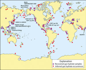
Location of sampled and inferred methane hydrate occurrences in oceanic sediment of outer continental margins and permafrost regions. Most of the recovered methane hydrate samples have been obtained during deep coring projects or shallow seabed coring operations. Most of the inferred methane hydrate occurrences are sites at which bottom simulating reflectors (BSRs) have been observed on available seismic profiles. The methane hydrate research drilling projects and expeditions reviewed in this report have also been highlighted on this map. (Map courtesy of Timothy S. Collett, USGS)
La géologie, une science plus que passionnante … et diverse
