Internal Multidecadal and Interdecadal Climate Oscillations: Absence of Evidence Is No Evidence of Absence

by G. Müller-Plath, Nov 29, 2020 in WUWT


Introduction

The present paper contributes a critical commentary on the recent finding by Mann, M. E., Steinman, B. A. and Miller, S. K (2020). Absence of internal multidecadal and interdecadal oscillations in climate model simulations. Nat. Commun. 11, 1–9.

Climate oscillations are recurring large-scale fluctuations in the surface temperatures of the oceans in connection with the atmosphere. This commentary focuses on the Pacific Decadal Oscillation (PDO, interdecadal timescale) and the Atlantic Multidecadal Oscillation (AMO, multidecadal timescale), which have been regarded as intrinsic climate drivers on the adjacent continents in numerous studies based on observations and paleoclimate reconstructions (Henley, 2017O’Reilly et al., 2017). In a recent paper, Michael E. Mann and colleagues (Mann et al., 2020, hereafter M20) fail to find a PDO signal in global measured and modeled temperatures that is statistically different from noise. They further propose that the significant AMO-like signal is mainly due to anthropogenic aerosols in the 20th century, and to statistical artifacts before. Therefore they doubt the intrinsic nature of the two oscillations. The present paper shows that M20’s results are largely artifacts themselves with issues ranging from using inadequate data and referencing improper literature on anthropogenic aerosols with regards to the AMO to inappropriately interpreting the results with regards to the PDO.


Measuring Old Corals & Coral Reefs (Part 1)

by J. Marohasy, Nov 29, 2020 in WUWT


Fundamental to science is measurement. It is a way of objectively assessing something, anything, even the state of a coral reef, even of an individual coral. Historically coral growth rates were measured by coring the really old massive Porites.

Like tree rings in temperate forests, the massive old Porites can be cored to see the banding and from this it is possible to calculate coral calcification rates which are a measure of the growth rate of individual corals.

Peter Ridd has been asking for some quality assurance of so many of the measurements relating to Great Barrier Reef health, including coral growth rates. Key Australian institutions have responded by stonewalling, and in the case of James Cook University, actually sacking him. After two rounds in the federal courts his appeal against his dismissal is finally going to the High Court of Australia, with the next hearing probably in February 2021. While the lawyers are preoccupied with Peter’s rights, or otherwise, to academic freedom and freedom of speech, my concern is whether Peter is actually telling the truth when he says that the Great Barrier Reef is resilient and definitely not dying from coral bleaching, though there is a problem with the integrity of the science.


Énergies renouvelables dans l’UE : de la perception aux réalités

by S. Furfari & E. Mund, 27 Nov 2020 in ConnaissanceEnergies


Nous assistons aujourd’hui à des conversations interminables sur l’« énergie » sans que ce dont on parle soit dûment précisé. Parle-t-on de l’énergie pour chauffer notre maison ou bien de celle nécessaire pour charger un véhicule électrique ? Ce n’est pas indifférent. Beaucoup ignorent les principes fondamentaux, alors que d’autres les connaissent mais évitent soigneusement d’en tenir compte.

L’un de ces principaux fondamentaux est la distinction entre « énergie primaire » et « énergie finale ». Précisons qu’il ne s’agit pas d’une vaine querelle de mots : une bonne compréhension a un impact fondamental en matière de choix de politique énergétique et d’adoption lucide de cette politique par les citoyens concernés.

Lorsque l’on ramène le poids des filières renouvelables intermittentes dans le bilan en énergie primaire de l’UE – l’indicateur fondamental lorsqu’on se préoccupe d’énergie, que ce soit pour les aspects géopolitiques, de balance des paiements et de décarbonation – leur part se limite ainsi à quelques pourcents. En 2018, ces énergies si populaires dans les médias n’ont ainsi compté que pour 2,5% de la consommation d’énergie primaire dans l’UE à 27 (1,4% en France, 1,8% en Belgique et 4,3% en Allemagne)…

Physicists: A CO2 Rise To 800 ppm Causes ‘Hypothetical’ 10°C Upper Atmosphere Cooling, 1.4°C Surface Warming

by Wijnagaarden & Happer, Nov 26, 2020 in NoTricksZone


At the current concentrations, the forcing power for greenhouse gases like CO2 (~400 ppm) and CH4 (1.8 ppm) are already saturated. Therefore, even doubling the current greenhouse gas concentrations may only increase their forcings “by a few percent” in the parts of the atmosphere where there are no clouds. When clouds are present, the influence of greenhouse gases is even further minimized.

While the “consensus” model view is that doubling CO2 from 280 ppm to 560 ppm results in a surface forcing of 3.7 W/m², Wijngaarden and Happer find doubling CO2 concentrations from 400 to 800 ppm increases climate forcing by 3 W/m². This warms the surface by 1.4 K as it “hypothetically” cools the upper atmosphere by 10 K.

Equilibrium climate sensitivity (when positive feedback with water vapor is included) is identified as 2.2 K, which is within 10% of multiple other analyses.

In The Climate Debate, It’s Either Fake News, Biased News, Or No News

by Ed Walbroehl, Nov 27, 2020 in ClimateChangeDispatch


Take your pick. The Mainstream Media (MSM) are using all three to stifle debate on climate change just like the current presidential election. What has happened to the American news media in this country?

I can remember a time when the MSM would do a story and would give you both sides of the issue and let the viewer decide what to think.

It’s amazing to see a business so willing to undermine its own credibility to push a certain narrative thinking everybody is stupid and will buy whatever they say.

In the case of the climate change issue, they even went as far as announcing no more so-called climate skeptics would be invited on their shows to give other opinions as is the case with NBC’s Meet the Press for example.

So much for a fair and balanced debate. Oh! I forgot. According to them, the science is settled. By who? That phrase the science is settled is the first clue that tells you a scientist is probably not a real scientist.

Real scientists know that new methods, learning, tools, ideas, and experiments will come about that will change our current knowledge and understanding of many scientific issues.

The MSM are even willing to lose viewers by lying to them. Look how foolish they looked when all this Russian collusion with the president turned out. Many viewers left after they found out they were being lied to.

Look what’s happening now as people start checking the facts on their own about climate change. They’re seeing that they are being lied to once again.

It’s probably why in many polls, the American people rank climate change near the bottom of what worries us, and why trust in the media is so low.

SKEPTICISM RISING – 150+ scientists including 60 Nobel Prize winners doubt that ‘climate change is caused by humans.

by J.G. Matkin, Nov 28, 2020 in AcademiaEdu

Surveys of public opinion show that a significant minority of the population are sceptical about climate change, and many suggest that doubt is increasing. The Internet, in particular the blogosphere, provides a vast and relatively untapped resource of data on the thinking of climate sceptics. This  paper focuses on one particular example where over 150 climate sceptics  provide information on their background, opinion on climate change and reasons for their scepticism. Although this data cannot be regarded as representative of the general public, it provides a useful insight into the reasoning of those who publicly question climate science on the web. Points of note include the high level of educational background, the significant numbers who appear to have been converted from a position of climate concern to one of scepticism, and the influence of blogs on both sides of the climate debate.
 
https://www.academia.edu/12247717/Why_are_people_sceptical_about_climate_change 
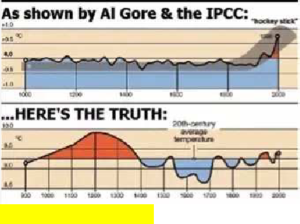
 The main concern of this group of sceptics is with the quality of the science, focusing on issues such as statistics, data handling and reliance on models, with the hockey stick picture acting as the icon for the dispute.
https://www.tandfonline.com/doi/… It is behind a paywall but there is a preprint version here: https://ipccreport.files.wordpre… The paper is based on comments that 150 skeptics wrote on a blog thread asking them about their background. Reasons include:
 
Hyped, exaggerated claims in the media
 Previous experience of scare stories that have failed to materialize
Political activism
Climategate
Shoddy science Full detail of survey results below :

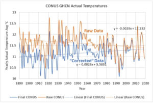
The U.S. National Temperature Index, is it based on data? Or corrections?

by Andy May, Nov 24, 2020 in WUWT


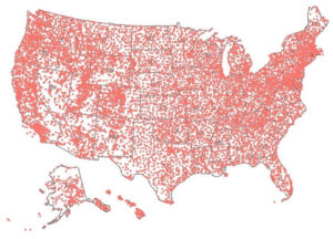
The United States has a very dense population of weather stations, data from them is collected and processed by NOAA/NCEI to compute the National Temperature Index. The index is an average temperature for the nation and used to show if the U.S. is warming. The data is stored by NOAA/NCEI in their GHCN or “Global Historical Climatology Network” database. GHCN-Daily contains the quality-controlled raw data, which is subsequently corrected and then used to populate GHCN-Monthly, a database of monthly averages, both raw and final. I downloaded version 4.0.1 of the GHCN-Monthly database on October 10, 2020. At that time, it had 27,519 stations globally and 12,514 (45%) of them were in the United States, including Alaska and Hawaii. Of the 12,514 U.S. stations, 11,969 of them are in “CONUS,” the conterminous lower 48 states. The current station coverage is shown in Figure 1.

Figure 1. The GHCN weather station coverage in the United States is very good, except for northern Alaska. There are two stations in the western Pacific that are not shown.

igure 4. The orange line is the uncorrected monthly mean temperature, which is “qcu” in NOAA terminology. The blue line is corrected, or NOAA’s “qcf.”

Growing interest in Moon resources could cause tension

by Harvard-Smithsonian Center for Astrophysics, Nov 23, 2020 in ScienceDaily


Resources like water and iron are important because they will enable future research to be conducted on, and launched from, the moon. “You don’t want to bring resources for mission support from Earth, you’d much rather get them from the Moon. Iron is important if you want to build anything on the moon; it would be absurdly expensive to transport iron to the moon,” said Elvis. “You need water to survive; you need it to grow food — you don’t bring your salad with you from Earth — and to split into oxygen to breathe and hydrogen for fuel.”

Interest in the moon as a location for extracting resources isn’t new. An extensive body of research dating back to the Apollo program has explored the availability of resources such as helium, water, and iron, with more recent research focusing on continuous access to solar power, cold traps and frozen water deposits, and even volatiles that may exist in shaded areas on the surface of the moon. Tony Milligan, a Senior Researcher with the Cosmological Visionaries project at King’s College London, and a co-author on the paper said, “Since lunar rock samples returned by the Apollo program indicated the presence of Helium-3, the moon has been one of several strategic resources which have been targeted.”

Carbon dioxide levels continue at record levels, despite COVID-19 lockdown

by WMO, Nov 23, 20°20


2020 Trends

The Global Carbon Project estimated that during the most intense period of the shutdown, daily CO2 emissions may have been reduced by up to 17% globally due to the confinement of the population. As the duration and severity of confinement measures remain unclear, the prediction of the total annual emission reduction over 2020 is very uncertain.


Field Geology on Mars Reveals Evidence of Megaflood

by D. Middleton, Nov 23, 2020 in WUWT


Field geology at Mars’ equator points to ancient megaflood
By Blaine Friedlander | November 18, 2020

Floods of unimaginable magnitude once washed through Gale Crater on Mars’ equator around 4 billion years ago – a finding that hints at the possibility that life may have existed there, according to data collected by NASA’s Curiosity rover and analyzed in joint project by scientists from Jackson State University, Cornell, the Jet Propulsion Laboratory and the University of Hawaii.

The research, “Deposits from Giant Floods in Gale Crater and Their Implications for the Climate of Early Mars,” was published Nov. 5 in Nature Scientific Reports.


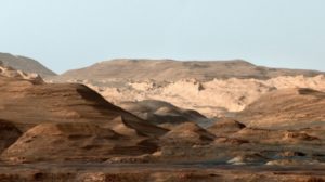
“This composite, false-color image of Mount Sharp inside Gale crater on Mars shows geologists a changing planetary environment. On Mars, the sky is not blue, but the image was made to resemble Earth so that scientists could distinguish stratification layers. NASA/JPL/Provided” (Cornell Chronicle)

The full text of the excellent paper is available:

[…]

“We identified megafloods for the first time using detailed sedimentological data observed by the rover Curiosity,” said co-author Alberto G. Fairén, a visiting astrobiologist in the College of Arts and Sciences. “Deposits left behind by megafloods had not been previously identified with orbiter data.”

[…]

The most likely cause of the Mars flooding was the melting of ice from heat generated by a large impact, which released carbon dioxide and methane from the planet’s frozen reservoirs. The water vapor and release of gases combined to produce a short period of warm and wet conditions on the red planet.

[…]

The Curiosity rover science team has already established that Gale Crater once had persistent lakes and streams in the ancient past. These long-lived bodies of water are good indicators that the crater, as well as Mount Sharp within it, were capable of supporting microbial life.

“Early Mars was an extremely active planet from a geological point of view,” Fairén said. “The planet had the conditions needed to support the presence of liquid water on the surface – and on Earth, where there’s water, there’s life.

“So early Mars was a habitable planet,” he said. “Was it inhabited? That’s a question that the next rover Perseverance … will help to answer.”

Perseverance, which launched from Cape Canaveral on July 30, is scheduled to reach Mars on Feb. 18, 2021.

[…]

Browse: Home / 2020 / November / 20 / “Sinking” Maldives Clear Forests, Pave Beaches, To Construct Four New Airports For Future Tourism! “Sinking” Maldives Clear Forests, Pave Beaches, To Construct Four New Airports For Future Tourism!

by P. Gosselin, Nov 20, 2020 in NoTricksZone


Despite all the money-generating gloomy predictions of sinking islands, we reported in 2013 on how the Maldives was planning to build 30 new luxury hotels for future tourists.

The resort island of Landaa Giraavaru (Baa atoll), photo by: Frédéric DucarmeCC BY-SA 4.0.

Underwater in 7 years?

We recall how in 2012, the former President of the Maldives Islands, Mohamed, Nasheed said: “If carbon emissions continue at the rate they are climbing today, my country will be underwater in seven years.”

4 new airports!

Well, today the islands have not gone underwater and remains popular with tourists like never before. And to help with the job of ferrying the 1.7 million (2019) tourists to and from the resort islands, the Maldives have recently opened 4 new airports, according to German site Aero here!

“We do not deny climate change”: Rupert Murdoch Responds to Accusations

by E. Worall, Nov 20, 2020 in WUWT


Tolerating diversity of opinion, in the form of providing wildly popular Murdoch Media personalities like Andrew Bolt a platform, does not mean Murdoch agrees with everything those personalities say.

But I guess old fashioned ideas like news managers giving their best journalists editorial freedom are no longer encouraged, at least when it comes to climate change.

Greens can be unforgiving of minor deviations from their dogma, even from people who helped found their movement.

Retired NASA scientist James Hansen, whose 1988 testimony pretty much kick started the climate movement, was accused of being a “denier” in 2015, because he does not think renewables alone will be enough to curb global CO2 emissions.

It is difficult to imagine someone being more alarmist than James Hansen; Hansen thinks the oceans will literally begin to boil if we don’t rapidly curb CO2 emissions. But Hansen still faced accusations of being a “denier”, because he thinks nuclear power should be an important part of the solution to climate change.

Field geology at Mars’ equator points to ancient megaflood

by Cornell University, Nov 20,2020 in ScienceDaily


Floods of unimaginable magnitude once washed through Gale Crater on Mars’ equator around 4 billion years ago — a finding that hints at the possibility that life may have existed there, according to data collected by NASA’s Curiosity rover and analyzed in joint project by scientists from Jackson State University, Cornell University, the Jet Propulsion Laboratory and the University of Hawaii.

The research, “Deposits from Giant Floods in Gale Crater and Their Implications for the Climate of Early Mars,” was published Nov. 5 in Scientific Reports.

The raging megaflood — likely touched off by the heat of a meteoritic impact, which unleashed ice stored on the Martian surface — set up gigantic ripples that are tell-tale geologic structures familiar to scientists on Earth.

“We identified megafloods for the first time using detailed sedimentological data observed by the rover Curiosity,” said co-author Alberto G. Fairén, a visiting astrobiologist in the College of Arts and Sciences. “Deposits left behind by megafloods had not been previously identified with orbiter data.”

As is the case on Earth, geological features including the work of water and wind have been frozen in time on Mars for about 4 billion years. These features convey processes that shaped the surface of both planets in the past.

This case includes the occurrence of giant wave-shaped features in sedimentary layers of Gale crater, often called “megaripples” or antidunes that are about 30-feet high and spaced about 450 feet apart, according to lead author Ezat Heydari, a professor of physics at Jackson State University.

The antidunes are indicative of flowing megafloods at the bottom of Mars’ Gale Crater about 4 billion years ago, which are identical to the features formed by melting ice on Earth about 2 million years ago, Heydari said.

Editorial: Deep Carbon Science

by D. Cardace et al., Nov 12, 2020 in Front.Earth.Sci.


Editorial on the Research Topic
Deep Carbon Science

Our understanding of the slow, deep carbon cycle, key to Earth’s habitability is examined here. Because the carbon cycle links Earth’s reservoirs on nano- to mega-scales, we must integrate geological, physical, chemical, biological, and mathematical methods to understand objects and processes so small and yet so vast. Here, we profile current research in the physical chemistry of carbon in natural and model systems, processes ongoing in the deepest portions of planets, and observations of carbon utilization by the deep biosphere. The relationships between the carbon cycle and planetary habitability are undeniable, forming a conceptual anchor to all work in deep carbon science.

Carbon minerals respond to changing pressures, temperatures, and geochemical conditions. The geologic record preserves evidence of transitional periods at the submicroscopic to regional landscape scales, and demonstrates interplay between carbon-bearing phases and the biosphere. In a new review, Morrison et al. (2020) cast a retrospective look through deep time and call for emerging approaches to clarify the coevolution of the biosphere and geosphere.

Critical to transformations of Earth’s carbon inventory over time are indomitable tectonics – which influence Earth’s surface environment, weathering, metamorphism, magmatism, and volcanism. The slow, deep (endogenous) carbon cycle refines and re-distributes carbon within Earth. In fact, over the 200-million-year-long time scale, important tectonic controls on carbon cycling emerge (Wong et al., 2019). Wong et al. (2019) document the spatiotemporal evolution of fluxes inferred from plate tectonic reconstructions, and highlight CO2 fluxes from continental rift settings post-Pangea. The volcanic flux of CO2 has been successfully reconstructed by direct study of CO2 flux through lakes and adjacent soils (Hughes et al., 2019), an important and often overlooked CO2 valve linking lithosphere, atmosphere, and hydrosphere. From perspectives rooted deeper in the tectonic system, the important roles that serpentinites play in the carbon cycle are evaluated in two senses: 1) serpentinite as a carbon vector to the deep mantle (Merdith et al., 2019), and 2) serpentine mud volcanoes as sites of carbon mobilization through organic acid release (Eickenbusch et al., 2019), in a Mariana Trench case study.

Continuer la lecture de Editorial: Deep Carbon Science

Atmospheric rivers help create massive holes in Antarctic sea ice

by Rutgers University, Nov 15, 2020 in WUWT


Warm, moist rivers of air in Antarctica play a key role in creating massive holes in sea ice in the Weddell Sea and may influence ocean conditions around the vast continent as well as climate change, according to Rutgers co-authored research.

Scientists studied the role of long, intense plumes of warm, moist air – known as atmospheric rivers – in creating enormous openings in sea ice. They focused on the Weddell Sea region of the Southern Ocean near Antarctica, where these sea ice holes (called polynyas) infrequently develop during the winter. A large hole in this area was first observed in 1973 and a hole developed again in the late winter and early spring of 2017.

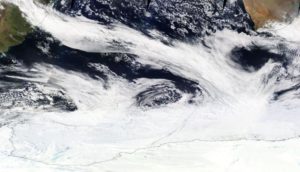
IMAGE: A BAND OF CLOUDS IN AN ATMOSPHERIC RIVER EXTENDING FROM SOUTH AMERICA TO THE ANTARCTIC SEA ICE ZONE ON SEPT. 16, 2017. view more CREDIT: NASA

In the first study of its kind, published in the journal Science Advances, scientists found that repeated strong atmospheric rivers during late August through mid-September 2017 played a crucial role in forming the sea ice hole. These rivers brought warm, moist air from the coast of South America to the polar environment, warming the sea ice surface and making it vulnerable to melting.

Possible 1,000-kilometer-long river running deep below Greenland’s ice sheet

by  Hokkaido University, Nov 12, 2020 in EurekaAlert


Computational models suggest that melting water originating in the deep interior of Greenland could flow the entire length of a subglacial valley and exit at Petermann Fjord, along the northern coast of the island. Updating ice sheet models with this open valley could provide additional insight for future climate change predictions.
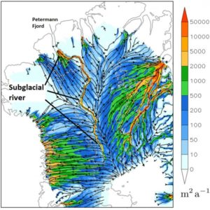
IMAGE: THE SUGGESTED VALLEY AND POSSIBLE RIVER FLOWING FROM THE DEEP INTERIOR OF GREENLAND TO PETERMANN FJORD DEEP BELOW GREENLAND’S ICE SHEET (500 METERS BELOW SEA LEVEL). (CHRISTOPHER CHAMBERS ET AL,… view more 

CREDIT: CHRISTOPHER CHAMBERS ET AL, THE CRYOSPHERE, NOVEMBER 12, 2020.

Radar surveys have previously mapped Greenland’s bedrock buried beneath two to three thousand meters of ice. Mathematical models were used to fill in the gaps in survey data and infer bedrock depths. The surveys revealed the long valley, but suggested it was segmented, preventing water from flowing freely through it. However, the peaks breaking the valley into segments only show up in areas where the mathematical modelling was used to fill in missing data, so could not be real.

Christopher Chambers and Ralf Greve, scientists at Hokkaido University’s Institute of Low Temperature Science, wanted to explore what might happen if the valley is open and melting increases at an area deep in Greenland’s interior known for melting. Collaborating with researchers at the University of Oslo, they ran numerous simulations to compare water dynamics in northern Greenland with and without valley segmentation.

The results, recently published in The Cryosphere, show a dramatic change in how water melting at the base of the ice sheet would flow, if the valley is indeed open. A distinct subglacial watercourse runs all the way from the melting site to Petermann Fjord, which is located more than 1,000 kilometers away on the northern coast of Greenland. The watercourse only appears when valley segmentation is removed; there are no other major changes to the landscape or water dynamics.

“The results are consistent with a long subglacial river,” Chambers says, “but considerable uncertainty remains. For example, we don’t know how much water, if any, is available to flow along the valley, and if it does indeed exit at Petermann Fjord or is refrozen, or escapes the valley, along the way.”

If water is flowing, the model suggests it could traverse the whole length of the valley because the valley is relatively flat, similar to a riverbed. This suggests no parts of the ice sheet form a physical blockade. The simulations also suggested that there was more water flow towards the fjord with a level valley base set at 500 meters below sea level than when set at 100 meters below. In addition, when melting is increased only in the deep interior at a known region of basal melting, the simulated discharge is increased down the entire length of the valley only when the valley is unblocked. This suggests that a quite finely tuned relationship between the valley form and overlying ice can allow a very long down-valley water pathway to develop.

“Additional radar surveys are needed to confirm the simulations are accurate,” says Greve, who has been developing the model used in the study, called Simulation Code for Polythermal Ice Sheets (SICOPOLIS). “This could introduce a fundamentally different hydrological system for the Greenland ice sheet. The correct simulation of such a long subglacial hydrological system could be important for accurate future ice sheet simulations under a changing climate.”

Uncertain Certainty: Germany’s Potsdam Climate Institute Humiliated After One-Year El Nino Forecast Model Flops

by P. Gosselin, Nov 15, 2020 in WUWT


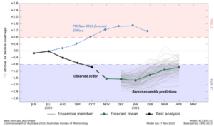
Last year Germany’s Potsdam Institute (PIK) boasted that it had a superior El Niño one-year forecasting model, claiming 80% certainty. Today, a year later, its forecast emerges totally wrong and the prestigious institute is left humiliated. 

Hat-tip: Snowfan

In 2019, Germany’s Potsdam Climate Institute (PIK) boasted that it had a superior El Niño forecasting model, claiming one year in advance and with 80% certainty, there would be an El Niño event late in 2020 (upper curve is just an El Niño illustration). But the PIK model forecast flopped totally. The opposite has in fact emerged. Chart source: BOM (with additions).

One year ago, together with researchers of the Justus Liebig University Giessen (JLU), and Bar-Ilan University in Ramat Gan in Israel, Germany’s alarmist yet highly regarded Potsdam Institute for Climate Research (PIK) boldly declared in a press release there would “probably be another ‘El Niño’ by the end of 2020.”

East African Rift System is slowly breaking away, with Madagascar splitting into pieces

by Virginia Tech, Nov 13, 2020 in ScienceDaily


The African continent is slowly separating into several large and small tectonic blocks along the diverging East African Rift System, continuing to Madagascar — the long island just off the coast of Southeast Africa — that itself will also break apart into smaller islands.

These developments will redefine Africa and the Indian Ocean. The finding comes in a new study by D. Sarah Stamps of the Department of Geosciences for the journal Geology. The breakup is a continuation of the shattering of the supercontinent Pangea some 200 million years ago.

Rest assured, though, this isn’t happening anytime soon.

“The rate of present-day break-up is millimeters per year, so it will be millions of years before new oceans start to form,” said Stamps, an assistant professor in the Virginia Tech College of Science. “The rate of extension is fastest in the north, so we’ll see new oceans forming there first.”

Visualizing All of Earth’s Satellites: Who Owns Our Orbit?

by T. Wood, Oct 20, 2020 in VisualCapitalist


Visualizing All of Earth’s Satellites

For centuries, humans have looked to space and the stars for answers. The fascination is more than philosophical—it’s coupled with the need to solve problems here on Earth.

Today, there are seemingly countless benefits and applications of space technology. Satellites, for instance, are becoming critical for everything from internet connectivity and precision agriculture, to border security and archaeological study.

Space is Open for Business

Right now, there are nearly 6,000 satellites circling our tiny planet. About 60% of those are defunct satellites—space junk—and roughly 40% are operational.

As highlighted in the chart above, The Union of Concerned Scientists (UCS), determined that 2,666 operational satellites circled the globe in April of 2020.

Over the coming decade, it’s estimated by Euroconsult that 990 satellites will be launched every year. This means that by 2028, there could be 15,000 satellites in orbit.

Tree rings may hold clues to impacts of distant supernovas on Earth

by University of Colorado at Boulder, Nov 11, 2020 in ScienceDaily


Massive explosions of energy happening thousands of light-years from Earth may have left traces in our planet’s biology and geology, according to new research by University of Colorado Boulder geoscientist Robert Brakenridge.

The study, published this month in the International Journal of Astrobiology, probes the impacts of supernovas, some of the most violent events in the known universe. In the span of just a few months, a single one of these eruptions can release as much energy as the sun will during its entire lifetime. They’re also bright — really bright.

“We see supernovas in other galaxies all the time,” said Brakenridge, a senior research associate at the Institute of Arctic and Alpine Research (INSTAAR) at CU Boulder. “Through a telescope, a galaxy is a little misty spot. Then, all of a sudden, a star appears and may be as bright as the rest of the galaxy.”

A very nearby supernova could be capable of wiping human civilization off the face of the Earth. But even from farther away, these explosions may still take a toll, Brakenridge said, bathing our planet in dangerous radiation and damaging its protective ozone layer.

To study those possible impacts, Brakenridge searched through the planet’s tree ring records for the fingerprints of these distant, cosmic explosions. His findings suggest that relatively close supernovas could theoretically have triggered at least four disruptions to Earth’s climate over the last 40,000 years.

The results are far from conclusive, but they offer tantalizing hints that, when it comes to the stability of life on Earth, what happens in space doesn’t always stay in space.

“These are extreme events, and their potential effects seem to match tree ring records,” Brakenridge said.

.

Tree rings (stock image).
Credit: © CrispyMedia / stock.adobe.com

Modern Climate Change Science

by A. May, Nov 12, 2020 in WUWT


The first modern theoretical estimates of ECS were reported in 1979 in the so-called “Charney Report” (Charney, et al., 1979). They reported, on page 2, a theoretical ECS of 1.5°C to 4.5°C per doubling of the CO2 atmospheric concentration. This estimate included an estimate of water vapor feedbacks, the effect of ice and their assumed uncertainties. Absent any water vapor feedback their computed value was 1°C per doubling of CO2. They also supply a likely value of 2.4°C on page 9, although on page 2 they offer a value “near 3.0.” The page 9 value is not far off from the empirical estimate of 2°C made by Guy Callendar in 1938, but significantly higher than the 1.2°C to 1.95°C (17% to 83% range, best estimate 1.5°C) given by Nic Lewis and Judith Curry (Lewis & Curry, 2018).

The IPCC, in their AR5 report (Bindoff & Stott, 2013), estimate ECS as lying between 1.5°C and 4.5°C and provide no best estimate. This range is precisely the same as the Charney Report made 34 years earlier. While the empirical, observation-based, estimates have narrowed significantly, the theoretical range has not changed, despite thousands of government-funded scientists spending billions of dollars trying to do so. The data is very much the same today and churning it faster with more powerful computers and billions of dollars doesn’t seem to matter. It works the same way with manure.

Digging deeply into the AR5 internals, as Monckton, et al. did in MSLB15, a paper entitled, “Why Models run hot: results from an irreducibly simple climate model” (Monckton, Soon, Legates, & Briggs, 2015), we see that the elements of the AR5 theoretical calculations suggest that the range is narrowing in a downward direction. Given the political environment at the IPCC, one can easily suspect that the politicians do not want to admit the theoretical risks of CO2-caused climate change are lessening. As more empirical estimates of the CO2 effect appear and more theoretical work is done, one wonders how long the politicians can support the clearly inflated range of 1.5°C to 4.5°C?

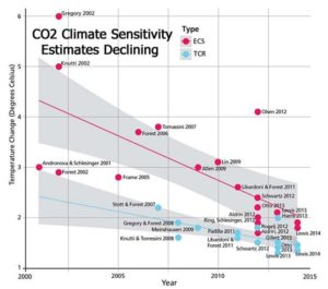
Estimates of ECS have been declining for a long time, as shown in 2017 by Nicola Scafetta and colleagues. Figure 1 is from their paper:

The decline in estimates of ECS from 2000 to 2015. Source: Scafetta, Mirandola, and Bianchini, 2017.

MULTIPLE COLD RECORDS FELL IN CALIFORNIA MONDAY

by Cap Allon, Nov 10, 2020 in Electroverse


After months of EOTW articles regarding California’s summer heat and largely self-inflicted wildfires, record COLD has now swept The Golden State — and the MSM has fallen eerily quiet

Before Monday rewrote the record books in western California, back-to-back weekend storms on Friday and Sunday brought frigid temperatures and heavy snow to much of the state, reports ktvu.com.

A whopping 18 inches of snow blanketed the Sierra-at-Tahoe ski resort and a healthy 10 inches accumulated at Sugar Bowl over the weekend, prompting a travel advisory throughout the Sierra Nevada.

Weekend Snowfall Totals [ktvu.com].

Forwarding to Monday, a number of low temperature records were broken.

It dropped to 38F (3.3C) at the Oakland Airport Monday morning, a reading that smashed the old record of 41F set in 2009 (solar minimum of cycle 23).

Gilroy, located in Santa Clara County, also set new low Monday — the city’s official reading of 31F (-0.6C) in the early hours of Nov 9 busted the old record of 34F (1.1C) set back in 1986 (solar minimum of cycle 21).

How ancient dust from the sea floor helps to explain climate history

by UNIVERSITY OF OLDENBURG, Nov 11, 2020 in WUWT


During the last Ice Age about 20,000 years ago, iron-containing dust acted as a fertilizer for marine phytoplankton in the South Pacific, promoting CO2 sequestration and thus the glacial cooling of the Earth. But where did the dust come from? Researchers led by Dr. Torben Struve, geoscientist at the University of Oldenburg, Germany, have investigated this open question of climate history, which is also relevant with respect to current climate change.

Using sediment cores from the sea floor, they found that a large part of the dust deposited in the southern South Pacific at that time had travelled an extremely long way. Up to 80 percent of the dust came from what is now north-west Argentina, from where it was transported almost completely around the globe by the prevailing westerly winds. After a voyage of up to 20,000 kilometres, it contributed significantly to the increased input of iron into the glacial South Pacific. The dust input from Australia, which dominates in the South Pacific today, played only a minor role. The research team has published these new insights into the mechanisms of natural iron input into the Southern Ocean in the journal Nature Communications.

“We have analysed the chemical fingerprint of the dust and compared it with geological data from several continents. This was laborious work, like a jigsaw puzzle,” says Struve, a post-doctoral scientist in the research group “Marine Isotope Geochemistry” at the University’s Institute for Chemistry and Biology of the Marine Environment (ICBM). The team included researchers from his group as well as colleagues from the Alfred Wegener Institute – Helmholtz Centre for Polar and Marine Research, Bremerhaven (Germany), and from Columbia University, New York (USA).

North Atlantic Cycle Change? Northern Europe October Temperature Trends Suggest Autumn Coming Sooner

by P. Gosselin, Nov 11, 2020 in NoTricksZone


Today we look at October mean temperatures for the emerald island country of Ireland, the Scandinavian country of Sweden and Finland.

Global warming alarmists claim that the globe is warming, which intuitively would tell us summers should be getting longer, which in turn would mean the start of fall is getting pushed back. In such a case, September and October temperatures should be warming, but they are not!

Cooling Ireland

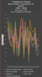
First we plot the mean temperature for 7 stations in Ireland for the month of October, for which the Japan Meteorological Agency (JMA) has sufficient data going back 25 years:

Data source: JMA

Seven of 7 stations in Ireland have seen a strong cooling trend for October since 1995.