by GWPF, June 05, 2019
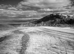
After conducting a comprehensive, seven-year survey of Patagonia, glaciologists from the University of California, Irvine and partner institutions in Argentina and Chile have concluded that the ice sheets in this vast region of South America are considerably more massive than expected.
hrough a combination of ground observations and airborne gravity and radar sounding methods, the scientists created the most complete ice density map of the area to date and found that some glaciers are as much as a mile (1,600 meters) thick. Their findings were published today in the American Geophysical Union journal Geophysical Research Letters.
…
by Roger I. Roots, May 30, 2019 in WUWT
Founder, Lysander Spooner University
May 30, 2019. St. Mary, Montana. Officials at Glacier National Park (GNP) have begun quietly removing and altering signs and government literature which told visitors that the Park’s glaciers were all expected to disappear by either 2020 or 2030.
In recent years the National Park Service prominently featured brochures, signs and films which boldly proclaimed that all glaciers at GNP were melting away rapidly. But now officials at GNP seem to be scrambling to hide or replace their previous hysterical claims while avoiding any notice to the public that the claims were inaccurate. Teams from Lysander Spooner University visiting the Park each September have noted that GNP’s most famous glaciers such as the Grinnell Glacier and the Jackson Glacier appear to have been growing—not shrinking—since about 2010. (The Jackson Glacier—easily seen from the Going-To-The-Sun Highway—may have grown as much as 25% or more over the past decade.)
…
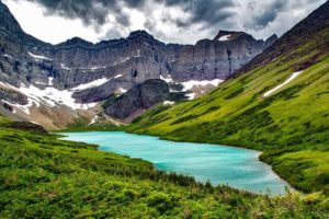
Montana Glacier National Park Mountains Cracker Lake
…
by David Middleton, June 6 , 2019 in WUWT
What is a highstand?
A highstand is one phase of the sea level cycle (AAPG Wiki)
- Rising
- Highstand
- Falling
- Lowstand
The highstand is the maximum sea level achieved during the cycle.
The Holocene Epoch
The Holocene Epoch was recently formally subdivided into three stages:
- Greenlandian Stage = Lower or Early-Holocene. 11.70 ka to 8.33 ka
- Northgrippian Stage = Middle or Mid-Holocene. 8.33 ka to 4.25 ka
- Meghalayan Stage = Upper or Late-Holocene. 4.25 ka to present
The abbreviation “ka” refers to thousands of years ago. Lower, Middle and Upper are generally used when referring to rock-time units. Early, Mid and Late are generally used when referring to time units (Haile, 1987). Prior to the formal subdivision, Lower/Early, Middle/Mid and Upper/Late were commonly used; however there was no formal nomenclature. The fake word, “Anthropocene” is not used by real geologists.
There is also an informal climatological subdivision of the Holocene:
- Preboreal 10 ka–9
- Boreal 9 ka–8 ka
- Atlantic 8 ka–5 ka
- Subboreal 5 ka–2.5 ka
- Subatlantic 2.5 ka–present
Source: Wikipedia
Why would there have been a Mid- to Late-Holocene highstand?
…
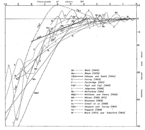
Figure 1. Holocene sea level curves from Moore & Curray, 1974.
…
La géologie, une science plus que passionnante … et diverse
