by P. Gosselin, May 14, 2019 in NoTricksZone
As the pressure mounts in Germany to switch off coal power plants and to rapidly transition over to green energies, one gets the feeling that it all has more to do with a desperate, last-ditch effort by the green energy proponents to rescue their pet green project.
Behind closed doors, no one in Berlin believes in it
Now, just days ago, energy expert Dr. Björn Peters wrote at the German Association of Employers site that the Energiewende has deteriorated to the point that: “No specialist politician in Berlin believes in the success of the Energiewende any more. Whoever you ask, everyone says this only behind closed doors and thinks that if you go to the press with it you can only lose against the ‘green’ media mainstream.”
Peters warns that what is needed in Germany is a good dose of reality and “a fresh start on energy policy.”
Advantages of fossil fuels “too great”
The German expert writes that despite the hundreds of billions of euros committed to green energies, “chemical energy from coal, oil and gas supplies about four fifths of primary energy worldwide and also in Germany and thus represents the present energy supply”.
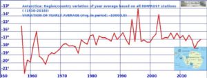
…