Scientists have described a fossil plant species that suggests flowers bloomed in the Early Jurassic, more than 174 million years ago, according to new research in the open-access journal eLife.
Before now, angiosperms (flowering plants) were thought to have a history of no more than 130 million years. The discovery of the novel flower species, which the study authors named Nanjinganthus dendrostyla, throws widely accepted theories of plant evolution into question, by suggesting that they existed around 50 million years earlier. Nanjinganthus also has a variety of ‘unexpected’ characteristics according to almost all of these theories.
Volcanoes are not fed by molten magma formed in large chambers finds a new study, overturning classic ideas about volcanic eruptions.
Instead, the study suggests that volcanoes are fed by so-called ‘mush reservoirs’ — areas of mostly solid crystals with magma in the small spaces between the crystals.
Our understanding of volcanic processes, including those leading to the largest eruptions, has been based on magma being stored in liquid-filled ‘magma’ chambers — large, underground caves full of liquid magma. However, these have never been observed.
The new study, by researchers at Imperial College London and the University of Bristol and published today in Nature, suggests the fundamental assumption of a magma chamber needs a re-think.
The levels of oxygen dramatically rose in the atmosphere around 2.4 billion years ago, but why it happened then has been debated. Some scientists think that 2.4 billion years ago is when organisms called cyanobacteria first evolved, which could perform oxygen-producing (oxygenic) photosynthesis.
Other scientist think that cyanobacteria evolved long before 2.4 billion years ago but something prevented oxygen from accumulating in the air.
Cyanobacteria perform a relatively sophisticated form of oxygenic photosynthesis — the same type of photosynthesis that all plants do today. It has therefore been suggested that simpler forms of oxygenic photosynthesis could have existed earlier, before cyanobacteria, leading to low levels of oxygen being available to life.
Now, a research team led by Imperial College London have found that oxygenic photosynthesis arose at least one billion years before cyanobacteria evolved. Their results, published in the journal Geobiology, show that oxygenic photosynthesis could have evolved very early in Earth’s 4.5-billion-year history.
What do you think are the biggest challenges right now in your field?
Some of the challenges are too hard for me even to pursue them. In the climate world, we don’t know about the role of clouds. And I don’t know how to pursue this, so I don’t pursue it. Do clouds have a cooling effect, and what is the response from clouds to warming? Will they slow or accelerate the warming? We don’t know. The role of clouds is certainly a big, big question. Although I do not work on this, I think about it, but I don’t see what to do.
One of the problems I do work on is what brought us Ice Ages. How did we go through 300 My years without much ice in the northern hemisphere and then suddenly, beginning 3My years ago or so, we had 5 big Ice Ages? Why? An easy answer is that now CO2 is higher. But it’s really hard to measure, determining CO2 in the past is a big question.
Another big question for me is how does the convection in the mantle connect with deformation in the lithosphere? How do these connect to one another?
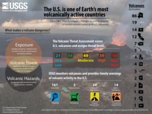
The United States has 161 young, active volcanoes within its borders. Since 1980, there have been 120 eruptions and 52 episodes of notable volcanic unrest at 44 U.S. volcanoes.
The U.S. Geological Survey systematically assesses U.S. volcanoes considered to be active or potentially active, and publishes a volcanic threat assessment that ranks the volcanoes based on 24 hazard and exposure factors. Last published in 2005, this 2018 update considers (1) field and laboratory research that adds or removes volcanoes from the list of potentially active volcanoes, and (2) updates the hazard and exposure factors used to produce a relative threat ranking of volcanoes.
Even long before medieval inhabitants reclaimed land and raised dykes at a large scale, humans have had a strong impact on river behavior in the Dutch delta plain. Physical geographers have demonstrated that two present Rhine branches developed stepwise in the first centuries CE, because of two combined man-induced effects.
A new study suggests that plate tectonics — a scientific theory that divides the earth into large chunks of crust that move slowly over hot viscous mantle rock — could have been active from the planet’s very beginning. The new findings defy previous beliefs that tectonic plates were developed over the course of billions of years.
The paper, published in Earth and Planetary Science Letters, has important implications in the fields of geochemistry and geophysics. For example, a better understanding of plate tectonics could help predict whether planets beyond our solar system could be hospitable to life.
“Plate tectonics set up the conditions for life,” said Nick Dygert, assistant professor of petrology and geochemistry in UT’s Department of Earth and Planetary Sciences and coauthor of the study. “The more we know about ancient plate tectonics, the better we can understand how Earth got to be the way it is now.”
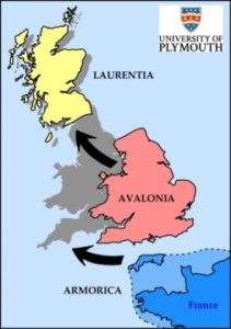
The British mainland was formed from the collision of not two, but three ancient continental land masses, according to new research.
Scientists have for centuries believed that England, Wales and Scotland were created by the merger of Avalonia and Laurentia more than 400 million years ago.
However, geologists based at the University of Plymouth now believe that a third land mass — Armorica — was also involved in the process.
The findings are published in Nature Communications and follow an extensive study of mineral properties at exposed rock features across Devon and Cornwall …
Through the analysis of samples, Broadley and his team tried to determine the composition of the lithosphere. They found that before the Siberian Flood Basalts took place, the Siberian lithosphere was heavily loaded with chlorine, bromine, and iodine, all chemical elements from the halogen group. However, these elements seem to have disappeared after the volcanic eruption.
“We concluded that the large reservoir of halogens that was stored in the Siberian lithosphere was sent into the earth’s atmosphere during the volcanic explosion, effectively destroying the ozone layer at the time and contributing to the mass extinction,” Broadley said.
The timing and size of three deadly earthquakes that struck Italy in 2016 may have been pre-determined, according to new research that could improve future earthquake forecasts.
A joint British-Italian team of geologists and seismologists have shown that the clustering of the three quakes might have been caused by the arrangement of a cross-cutting network of underground faults.
The findings show that although all three earthquakes occurred on the same major fault, several smaller faults prevented a single massive earthquake from occurring instead and also acted as pathways for naturally occurring fluids that triggered later earthquakes.
We derive a timescale of life, combining a reappraisal of the fossil material with new molecular clock analyses. We find the last universal common ancestor of cellular life to have predated the end of late heavy bombardment (>3.9 billion years ago (Ga)). The crown clades of the two primary divisions of life, Eubacteria and Archaebacteria, emerged much later (<3.4 Ga), relegating the oldest fossil evidence for life to their stem lineages. The Great Oxidation Event significantly predates the origin of modern Cyanobacteria, indicating that oxygenic photosynthesis evolved within the cyanobacterial stem lineage. Modern eukaryotes do not constitute a primary lineage of life and emerged late in Earth’s history (<1.84 Ga), falsifying the hypothesis that the Great Oxidation Event facilitated their radiation…
The biogenicity of putative traces of life found in early-Archean rocks is strongly debated. To date, only equivocal lines of evidence have been reported, which has prevented a full consensus from emerging. Here we report elemental and molecular data from individual organic microfossils preserved within the 3.4 billion-year-old cherts of the Strelley Pool Formation, Western Australia. The present results support the growing body of evidence advocating their biogenicity, promoting them as the oldest known authentic organic microfossils. These microfossils consist of nitrogen- and oxygen- rich organic molecules that have been only slightly degraded despite experiencing temperatures of ~300 °C. Such molecular preservation emphasises the palaeobiological potential of the Earth’s oldest geological record, whilst providing a promising window into the early biosphere.
The findings, published in the journal Nature, represent the oldest measurement of atmospheric oxygen isotopes by nearly a billion years. The results support previous research suggesting that oxygen levels in the air during this time in Earth history were a tiny fraction of what they are today due to a much less productive biosphere.
“It has been suggested for many decades now that the composition of the atmosphere has significantly varied through time,” says Peter Crockford, who led the study as a PhD student at McGill University. “We provide unambiguous evidence that it was indeed much different 1.4 billion years ago.”
The study provides the oldest gauge yet of what earth scientists refer to as “primary production,” in which micro-organisms at the base of the food chain — algae, cyanobacteria, and the like — produce organic matter from carbon dioxide and pour oxygen into the air.
There may be more than a quadrillion tons of diamond hidden in the Earth’s interior, according to a new study from MIT and other universities. But the new results are unlikely to set off a diamond rush. The scientists estimate the precious minerals are buried more than 100 miles below the surface, far deeper than any drilling expedition has ever reached.
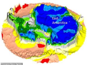
The ultradeep cache may be scattered within cratonic roots — the oldest and most immovable sections of rock that lie beneath the center of most continental tectonic plates. Shaped like inverted mountains, cratons can stretch as deep as 200 miles through the Earth’s crust and into its mantle; geologists refer to their deepest sections as “roots.”
In the new study, scientists estimate that cratonic roots may contain 1 to 2 percent diamond. Considering the total volume of cratonic roots in the Earth, the team figures that about a quadrillion (1016) tons of diamond are scattered within these ancient rocks, 90 to 150 miles below the surface.
L’ Anthropocène est la dernière création marketing d’un géologue. Avec un certain succès médiatique alors que les scientifiques s’y opposent fermement. Pourquoi ?
Discovery provides evidence of iron-rich seawater much later than previously thought.
The banded iron formation, located in western China, has been conclusively dated as Cambrian in age. Approximately 527 million years old, this formation is young by comparison to the majority of discoveries to date. The deposition of banded iron formations, which began approximately 3.8 billion years ago, had long been thought to terminate before the beginning of the Cambrian Period at 540 million years ago.
The Early Cambrian is known for the rise of animals, so the level of oxygen in seawater should have been closer to near modern levels. “This is important as the availability of oxygen has long been thought to be a handbrake on the evolution of complex life, and one that should have been alleviated by the Early Cambrian,” says Leslie Robbins, a PhD candidate in Konhauser’s lab and a co-author on the paper.
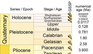
The International Commission on Stratigraphy (ICS) has announced that the proposal by the International Subcommission on Quaternary Stratigraphy (ISQS) for the subdivision of the Holocene Series/Epoch has been ratified unanimously by the International Union of Geological Sciences (IUGS).
(…)
nb: ‘No Christiana, the geologists do not think the Anthropocene is a concept worthy of consideration, and you should be better informed.’
On 27 and 28 September 2017, eight large rockfalls occurred from the southeast face of El Capitan. These rockfalls resulted in one fatality and two serious injuries, and spurred a complicated rescue and temporary closure of the main road exiting Yosemite Valley. In order to manage these challenging events, the National Park Service (NPS) had a critical, immediate need for quantitative information about the sequence of rockfalls and the potential for additional activity.
Using new “structure-from-motion” photogrammetry techniques in conjunction with baseline laser-scanning data, scientists from the NPS, the U.S. Geological Survey, and the University of Lausanne, Switzerland rapidly analyzed these rockfalls. By comparing 3-dimensional (3D) models of the cliff before, during, and after the rockfalls, the researchers were able to pinpoint the exact locations, dimensions, and volumes of the rockfalls, along with the spatial and temporal pattern of their progression up the cliff.
Scientists have argued for decades over what may have caused this mass extinction, during what is called the “Ediacaran-Cambrian transition.” Some think that a steep decline in dissolved oxygen in the ocean was responsible. Others hypothesize that these early animals were progressively replaced by newly evolved animals.
The precise cause has remained elusive, in part because so little is known about the chemistry of Earth’s oceans that long ago.
A research team, led by scientists from Arizona State University and funded by NASA and the National Science Foundation, is helping to unravel this mystery and understand why this extinction event happened, what it can tell us about our origins, and how the world as we know it came to be. The study, published in Science Advances, was led by ASU School of Earth and Space Exploration graduate student Feifei Zhang, under the direction of faculty member Ariel Anbar and staff scientist Stephen Romaniello. (…)
The discovery of the Durmid Ladder reveals the southern tip of the San Andreas Fault changes fairly gradually into the ladder-like Brawley Seismic zone. The structure trends northwest, extending from the well-known main trace of the San Andreas Fault along the Salton Sea’s northeastern shore, to the newly identified East Shoreline Fault Zone on the San Andreas’ opposite edge.
“We now have critical evidence about the possible nucleation site of the next major earthquake on the San Andreas Fault,” says Jänecke, professor in USU’s Department of Geology. “That possible nucleation site was thought to be a small area near Bombay Beach, California, but our work suggests there may be an additional, longer ‘fuse’ south of the Durmid Ladder within the 37-mile-long Brawley Seismic zone.” …
Some of the earliest complex organisms on Earth — possibly some of the earliest animals to exist — got big not to compete for food, but to spread their offspring as far as possible.
The research, led by the University of Cambridge, found that the most successful organisms living in the oceans more than half a billion years ago were the ones that were able to ‘throw’ their offspring the farthest, thereby colonising their surroundings. The results are reported in the journal Nature Ecology and Evolution.
Prior to the Ediacaran period, between 635 and 541 million years ago, life forms were microscopic in size, but during the Ediacaran, large, complex organisms first appeared, some of which — such as a type of organism known as rangeomorphs — grew as tall as two metres.
Le Précambrien représente 88% de l’histoire de la Terre âgée de 4,567 milliards d’années (Ga).
C’est au cours de cette période peu connue, peu enseignée que se sont déroulés ou mis en place des événements physico-chimiques et biologiques déterminants: différenciation des enveloppes terrestres, tectonique des plaques et premières ‘pangées’ ou supercontinents, champ magnétique, chaînes de montagnes, glaciations, anoxies des bassins, remplacement du CO2-CH4par l’oxygène atmosphérique, formation de gisements (uranium, manganèse, nickel …. et même pétrole), émergence dès 3,8 Ga des procaryotes puis des eucaryotes …
Vu l’absence de fossiles stratigraphiques, et donc de biozones, la stratigraphie du Précambrien est encore très difficile, elle est intialement basée sur la lithostratigraphie. De grands progrès ont récemment été réalisés grâce à la chimiostratigraphie istotopique (C, O, Sr….) en plus de la radiométrie absolue.
L’exposé se consacrera aux événements sédimentaires liés au Grand Evénement de l’Oxygène il y a environ 2,5-2,1 Ga (Paléoprotérozoïque) et à ceux liés à la ‘Terre Boule de Neige’ (Snowball Earth) avec la glaciation marinoenne il y a 0,635 Ga (Néoprotérozoïque), à partir des séries de l’Afrique de l’Ouest.
By Field Museum, May 24, 2018 in ScienceDaily (CurrentBiology)
Sixty-six million years ago, the world burned. An asteroid crashed to Earth with a force one million times larger than the largest atomic bomb, causing the extinction of the dinosaurs. But dinosaurs weren’t the only ones that got hit hard — in a new study, scientists learned that the planet’s forests were decimated, leading to the extinction of tree-dwelling birds.
Clues from some unusual Arizona rocks pointed Rice University scientists toward a discovery — a subtle chemical signature in rocks the world over — that could answer a long-standing mystery: What stole the iron from Earth’s continents?
The find has weighty implications. If the iron content of continental rocks was a bit greater, as it is in the rocks beneath Earth’s oceans, for example, our atmosphere might look more like that of Mars, a planet so littered with rusty, oxidized rocks that it appears red even from Earth.
In a new paper available online in Science Advances, Rice petrologists Cin-Ty Lee, Ming Tang, Monica Erdman and Graham Eldridge make a case that garnet steals the most iron from continents. The hypothesis flies in the face of 40-plus years of geophysical thinking, and Tang, a postdoctoral fellow, and Lee, professor and chair of the Department of Earth, Environmental and Planetary Sciences at Rice, said they expect a healthy dose of skepticism from peers.
“The standard view … (…)
La géologie, une science plus que passionnante … et diverse