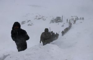
Latest GFS runs are forecasting a truly frosty and snowy next 7+ days for the majority of Europe, as winter continues to encroach ever-further into spring — a phenomenon long-predicted by those who study the Sun’s impact on climate.
Beginning this weekend, brutal Arctic cold will engulf practically ALL of Europe sinking temperatures some 16C below-the-seasonal-average for many:
…
…and there’s plenty more where that came from.
GFS runs are predicting rare April snow accumulating during the next 14-or-so days, particularly in Norway, Sweden, NE Russia, Latvia, Lithuania, Belarus, Ukraine, the Balkans, Italy, the Alps, Spain, and even the UK (also, note the substantial falls in Eastern Turkey, Georgia, Armenia and Azerbaijan):
Past civilizations shown to peak during times of warmth (Grand Solar Maximums), and then almost-instantly collapse during the subsequent & sharp cool-downs (Grand Solar Minimums).
Even NASA agrees, in part at least, with their forecast for this upcoming solar cycle (25) revealing it will be “the weakest of the past 200 years,” with the agency correlating previous solar shutdowns to prolonged periods of global cooling here.
The MSM has a blatant warm-bias, that’s been clear for years…
A myriad of news outlets were all-too-happy to run with the Antarctic Peninsula’s record warm temperature last month, painting it as further evidence of the coming climate catastrophe (despite the peninsula actually being located closer to Argentina than the South Pole, and the event officially going down as a foehn). But where are those same rags now? Where is their balance? Their credibility? Or is informing the public not the goal anymore, is their mission merely to propagandize?
Last Friday, Antarctica set its coldest EVER March temperature…
…somehow, in what we’re to believe is a linearly warming world on the brink of “overheating”, the world’s southernmost continent is currently the coldest its ever been for the time of year.
The Vostok Station clocked a bone-chilling -75.3C (-103.54F) on the morning of Friday, March 20, as spotted by @TempGlobal on Twitter:
The first flakes of the season in Kiruna, Sweden fell back on Sept 30 and from then on have continued relentlessly, with accumulations now comfortably surpassing the region’s all-time snowfall record.
NASA has recently revealed this upcoming solar cycle (25) will be “the weakest of the past 200 years,” with the agency correlating previous solar shutdowns to prolonged periods of global cooling here.
Australia’s “Grand Solar Minimum” summer –which brought record cold/heat, drought/floods, fires, and dust storms– had one final sting in the tail: another flurry of rare summer snow.
While summer down-under officially ended on Saturday, Feb 29, another blast of heavy, unexpected snow began burying parts of Tasmania on Wednesday, Feb 26.
Mountainous areas of the isolated island state reported large accumulations to close out the week, with local meteorologists warning yet more snow could settle above 1,000 m (3,280 ft) –including at Mount Field and Wellington– over the coming days.
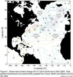
From 2008 to 2016 a widespread cooling ranging from 0.6°C to more than 2.0°C has chilled effectively the entire oceanic region from E. Canada to N. Iceland to S. Europe. The cooling persists year-round and extends from the surface down to depths of 800 m.
A year ago scientists revealed a large swath of the North Atlantic surface had cooled at a rate of -0.78°C per decade between 2004 and 2017 (Fröb et al., 2019).
Greenland’s largest glacier (Jakobshavn) has quite abruptly thickened since 2016. The thickening has been so profound the ice elevations are nearly back to 2010-2011 levels. The nearby ocean has cooled ~1.5°C – a return to 1980s-era temperatures.
The world’s glaciers have not been following along with the CO2-driven catastrophic melting narrative.
Alaska
For example, in a study of 50 Alaskan glaciers for the warming period between 1972-2012, researchers (McNabb and Hock, 2014) found there was
“…no corresponding change in the number of glaciers retreating nor do we see corresponding acceleration of retreat rates. To the contrary, many glaciers in the region have advanced…”
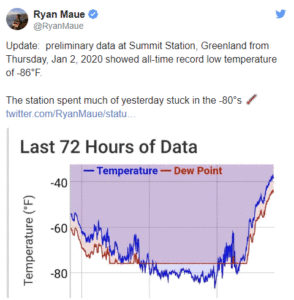
The coldest ever day recorded in Greenland stands at -63.3 C (minus 81 F). But on January 2nd in 2020, after Greenland suffered a century of global warming, the thermometer at Summit Camp sunk to at least -64.9C. I say, at least, because it may have been even colder. Sharp eyes of Cap Allon at Electroverse saw it hit minus 66C. Ryan Maue also saw it and predicted there would be cold as the Arctic Oscillation broke down.
I sought confirmation at the time (among the Bushfire days in Australia). I looked for any official tweet even, but couldn’t find any. How’s that work — a new all time record for a whole continent for any month of the year, and no one who was paid to care about these things even writes a paragraph?
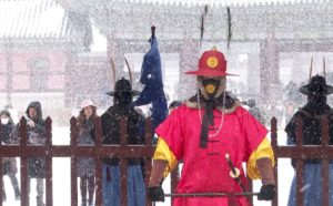
Seoul received its largest single-day snowfall of the season on Monday as 4.1cm (1.6 inches) settled in South Korea’s capital city, adding to the 3.9cm (1.54 inches) from the previous day, the Korea Meteorological Administration (KMA) said.
The Monday morning mercury plunged to -5.5C 22.1F) in Seoul, with a harsh windchill making it feel more like –10.5C (13.1F). The KMA added that temps will dip even further tomorrow (Tues), to -8C (17.6F).
Icy roads resulted in a 20 vehicle pile-up inside a tunnel connecting Suncheon and Wanju in North Jeolla on Monday, leaving three people dead and another 38 others injured, according to police.
A chemical truck carrying sodium hydroxide was one of the vehicles involved in the accident. Police said the truck caught fire and caused a toxic gas leak in the tunnel, hindering rescue efforts.
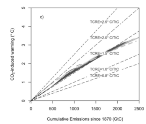
A range of scenarios for global mean surface temperature change between 2020 and 2050, derived using a semi-empirical approach. All three modes of natural climate variability – volcanoes, solar and internal variability – are expected to act in the direction of cooling during this period.
In the midst of all the angst about 1.5oC or 2.0oC warming or more, as defined relative to some mythical time when climate was alleged to be ‘stable’ and (relatively) uninfluenced by humans, we lose sight of the fact that we have a better baseline period – now. One advantage of using ‘now’ as a baseline for future climate change is that we have good observations to describe the climate of ‘now’.
While most of the focus of climate projections is on 2100, the period circa 2020-2050 is of particular importance for several reasons:
It is the period for meeting UNFCCC targets for emissions reductions
Many financial and infrastructure decisions will be made on this time scale
The actual evolution of the climate over this period will influence 1) and 2) above; ‘surprises’ could have adverse impacts on decisions related to 1) and 2).
Figure 1: CO2-induced warming as a function of cumulative emissions and TCRE. Millar et al
Ukraine and Romania were two of the hardest hit Eastern European nations during last week’s extreme winter weather.
In Romania’s capital Bucharest, the severe blizzard has reportedly felled more than 100 trees — many falling onto roads and vehicles — while billboards, traffic lights, and “construction elements” were also toppled, according to the Bucharest-Ilfov Emergency Inspectorate.
450+ schools were closed across the country on Feb. 6 and 7 due to the heavy snowfall, and public transport was cancelled following an incident with a bus colliding with a tram in icy conditions.
by W. Jones, January 22, 2020 in ClimateChangeDispatch
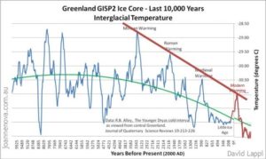
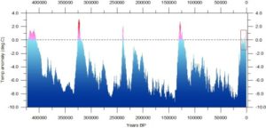
Did you know that over the last 450,000 years there have been four Ice Ages lasting around 100,000 years each?
And five interglacial periods lasting around 12,000 years each?
Look at this graph of temperature data derived from the Vostok ice core from Antarctica.
What it means is that for around 90 percent of the last 450,000 years Earth has been in an Ice Age, where global temperatures have slumped to as low as 10 deg C colder than in the relatively brief interglacial periods.
The current interglacial period (the fifth) began about 11,600 years ago, suggesting it may not last much longer. It corresponds to the time when human beings began farming and building cities and civilizations.
It is notably cooler than the previous four interglacial periods. If we ‘zoom in’ on it (see the upper graph, below)
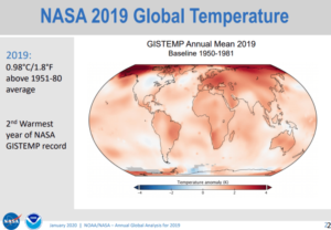
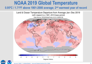
Today, at the big 100 year anniversary shindig of the American Meteorological Society (AMS) there was a press release session that featured NOAA and NASA GISS talking about how their climate data says that the world in 2019 was the second warmest ever.
In my opinion, the NOAA/NASA press release (and slideshow) is inconsistently presented. For example, they can’t even agree on a common base period for comparisons. Some graphs use 1951-1980 while others compare to 1981-2010 averages to create anomaly plots. NOAA and NASA owe it to the public to present climate data with a consistent climate period for comparison, otherwise it’s just sloppy science. NASA GISS has consistently resisted updating the 1951-1980 NASA GISS baseline period to the one NOAA and other datasets use, which is 1981-2010. GISS stubbornly refuses to change even though they have been repeatedly excoriated for keeping it.
That 1951-1980 period just so happens to be the coolest period in the 20th century, so by using that as a baseline, the peak amount of warming anomaly is magnified in NASA GISS plots. Most laymen will never spot this. A simple comparison of the two maps show the difference in the peak values:
Global warming alarmists like claiming that a certain place is seeing more warming and climate change than everywhere else. Remarkably, they say that about almost everywhere, which of course makes no sense.
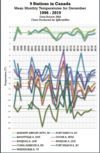
Today we look at Canadian temperature trends using the data from the Japan Meteorological Institute (JMA) for stations where they have data available going back to at least the mid 1990s.
First we look at December mean temperatures. What follows is a chart depicting the results of 9 stations across Canada:
Of the 9 examined stations, seven show no warming taking place at all in Canada over the past quarter century for the month of December. Data: JMA.
With fewer than 2 full-days remaining, India’s capital Delhi is about to register its second-coldest month of December since records began in 1901.
According to data from India’s Meteorological Department (IMD), Delhi’s December mean maximum temperature has only-ever dipped below 20C (68F) in 1919, 1929, 1961, 1973 and 1997.
“In December this year, the mean maximum temperature until Thursday [Dec 26] was 19.85C,” said an IMD official. And, given the current forecast, “it is expected to dip to [at least] 19.15C by December 31” — the second-coldest reading after 1973’s mean max temp of 17.3C (63.1F).
Saturday, December 28 saw the season’s lowest daily temperature at the Safdarjung Observatory –Delhi’s official weather station– when a minimum of 2.4C (36.3F) was recorded.
The following day, on Sunday, the IMD issued a “code red” cold warning for Delhi, Haryana, and other neighboring states. Adding to the anomalously cold, dense fog reduced visibility and disrupted air, rail and road traffic.
In the face of Global Warming we see scenarios from the ice age.
The Alps were submerged in snow, with truly dramatic accumulations up to 1,500m above sea level, especially considering that we are still at the end of November.
Here are the incredible data:
295cm of snow on the ground at Rifugio Gastaldi – Balme (2.659m asl), 263cm at Macugnaga Rifugio Zamboni (2.075m), 239cm at Rifugio Vaccarone – Giaglione (2.745) m), 227cm at Lago Agnel – Ceresole Reale (2.304m), 222cm at Lago Dietro La Torre – Usseglio (2.360m) and Bocchetta Delle Pisse – Alagna Valsesia (2.410m), 197cm at Larecchio – Montecrestese (1.860m) and Lemon Pancani – Limone Piemonte (1.875m), 191cm in Formazza (2.453m), 188cm in the Del Chiotas Dam – Entracque (2.020m), 185cmin Malciaussia – Usseglio (1,800m), 172cm at Passo Del Moro – Macugnaga (2.820m), 169cm in Clot Of Soma – Pragelato (2.150m), 166cm in Alpe Veglia – Varzo (1.740m), 164cm in Grange Martina – Giaglione (1.967m), 163cm Pian Giasset – Crissolo (2.150m) and Lago Pilone – Sauze D’oulx (2.280m), 156cm Rifugio Mondovi – Roccaforte Mondovi (1.760m), 152cm at Sommeiller – Bardonecchia (2.981m), 150cm in Pian Delle Baracche – Sampeyre (2.135m), 137cm in Alpe Devero – Baceno (1.634m), 129cm in Camparient – Trivero (1.515m), 124cm in Sestriere (2.020m).
Per approfondire http://www.meteoweb.eu/2019/11/meteo-alpi-sommerse-neve-piemonte-sestriere/1350156/#U03AfALMXOVSWFCe.99
The mercury in San Francisco reached a high of just 8.8C (48F) on Thursday, November 28, tying the 1896 (solar minimum of cycle 12)record for the city’s lowest-max temp ever recorded in November.
And San Francisco wasn’t alone in dealing with below-average temperatures late last week. According to the National Weather Service, much of the interior North Bay suffered sub-zero readings overnight Thursday:
Novato Airport recorded a nipple-hardening -5C (23F).
Santa Rosa and Napa County Airport dipped to -3.3C (26F).
Sonoma Airport bottomed out at -2.8C (27F).
While temps touched freezing point at Livermore Airport.
2.8C (37F) at Oakland Airport and San Jose.
And 5C (41F) in San Francisco.
(Readings all highly unusual for the time of year).
Winter has not even officially arrived, but already large areas of the northern hemisphere are seeing “historic snowfalls”, frigid temperatures and even avalanche alarms.
The Northern Hemisphere has certainly caught a major cold, one certainly not caused by the human CO2 virus. Instead of fever, parts of the northern hemisphere are in hypothermia!
Alarmists, media desperate
Though global warming scientists will never admit it, they are really surprised and stunned. All that is left for them is to make up some cockamamie warming-causes-cold explanations and hope there are enough severely stupid among the media and masses to believe it.
“United States — Rewrite the Record Books”
Beginning in North America, “sub-zero temperatures are now blasting” millions of Americans following “the three historic snowstorms which buried parts of the U.S. last month,” reports weather site electroverse.net here.
Electroverse writes that “lows throughout the week will be more like January temperatures” with readings below zero for many U.S. states and “temps down into the teens are even forecast as far south as Texas.” Yesterday, 97 records toppled.
“It’s a big deal,” Electroverse writes in its headline.
Solar activity suspected
It’s not the sort of thing we are supposed to be expecting from a “warming planet”. Some climate experts blame natural factors, like solar activity, for the cold, and that these warnings have long been known since the sun has entered a new period of calm.
Freeze watches and warnings also extend as far south as Florida. And it’s only early November. And don’t expect to see many FFF activists to show up at rallies protesting hot weather any time soon.
Polar Bear Science site here also reports that the Hudson Bay in Canada has started freezing up earlier than normal three years in a row!
Europe starting to get clobbered by snow, 2m in Alps
Meanwhile cold has also spread across Europe, though not quite as brutal as what we’ve been seeing across North America.
It’s been acknowledged by mainstream scientists for years now that at certain locations on planet Earth, rising carbon dioxide levels cause cooling. It’s now been determined that rising CO2 also causes “negligible” cooling (or warming) depending on the season.
A few years ago a seminal paper (Schmithüsen et al., 2015) was published in Geophysical Research Letters that indicated raising the concentration of CO2 causes a negative greenhouse effect, or cooling, in central Antarctica.
The forcing from the CO2 greenhouse effect ranges from -2.9 W/m² to +1 W/m², and the forcing for the Arctic (central Greenland) is said to be “comparably weak”.
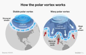
The GFS and it’s ensembles are forecasting a dramatic reduction in westerly Zonal winds over the North Pole during the latter half of November and throughout December.
Conversely, October and the first half of November brought very strong Zonal winds at 60N, which went hand-in-hand with below-average temperatures at the Pole — Zonal winds in the stratosphere strengthen as the temperature over the North Pole drops:
…
IMPACTS OF AN SSW
Following the onset of an SSW event, temperatures at the pole will often climb sharply, and the high altitude winds will have reversed to flow in an eastward direction instead of their usual westward one.
These eastward winds progress down through the atmosphere and weaken the jet stream, often resulting in easterly winds near the surface which usually bring with them a dramatic drop in temperatures across Europe and North America.
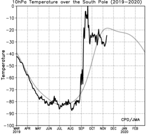
Check out what happened to temps over the South Pole in September as an SSW took hold there:
Northern Africa caught the edges of Europe’s polar blast over the weekend and into Monday. Heavy snowfall affected several wilayas (provinces) in Algeria yesterday, as reported by alg24.net.
The key national road 33, linking Bouira to Tizi-Ouzou, was closed during Monday morning rush-hour near the town of El Asnam. As was the RN30, the alternative route connecting Bouira to Tizi-Ouzou.
Heavy early-season drifts also shut national road 15 near Iferhounene, in the wilaya of Tizi-Ouzou.
Same case for the RN109 linking Sidi Bel Abbès and El-Bayadh.
And the road 172, located between Djbel Chélia and Lyabous (Khenchela) was also shut.
Winter has not even officially arrived, but already large areas of the northern hemisphere are seeing “historic snowfalls”, frigid temperatures and even avalanche alarms.
The Northern Hemisphere has certainly caught a major cold, one certainly not caused by the human CO2 virus. Instead of fever, parts of the northern hemisphere are in hypothermia!
Alarmists, media desperate
Though global warming scientists will never admit it, they are really surprised and stunned. All that is left for them is to make up some cockamamie warming-causes-cold explanations and hope there are enough severely stupid among the media and masses to believe it.
“United States — Rewrite the Record Books”
Beginning in North America, “sub-zero temperatures are now blasting” millions of Americans following “the three historic snowstorms which buried parts of the U.S. last month,” reports weather site electroverse.net here.
Electroverse writes that “lows throughout the week will be more like January temperatures” with readings below zero for many U.S. states and “temps down into the teens are even forecast as far south as Texas.” Yesterday, 97 records toppled.
“It’s a big deal,” Electroverse writes in its headline.
Brutal Arctic fronts have engulfed Scandinavia over the past few weeks. The record for Finland’s lowest-ever Autumn temp has just been smashed (for the second time this week), as has Sodankylä’s all-time snow-depth record (for early Nov).
The temperature in Enontekiö –a municipality in the Finnish part of Lapland– plunged to a Santa-freezing –28.2C(-18.8F) on Tuesday, Nov 5; beating-out the nation’s previous all-time autumnal low set just the previous day — Muonio’s -26.4C (15.5F) –located in far-northern Finland.
The previous record low for any autumn day in Enontekio was -26.3C (-15.3F).
Temperatures below -27C (-16.6F) were also recorded in Sodankylä, Luosto, and Kittilä on Tuesday, breaking local all-time record lows.
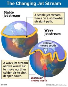
According to official NOAA data, more than twelve-hundred monthly low temperature records fell ACROSS the U.S. in October 2019 — multiple Arctic air masses rode anomalously-far south on the back of a wavy jet stream flow, itself associated with historically low solar activity.
The sun is currently in its deepest solar minimum of the past 100+ years, and the jet stream has weakened as a result; its usual tight ‘zonal’ flow has more-often-than-not reverted to a loose ‘meridional’ one. This wavy flow has diverted brutal Arctic air into the lower-latitudes, and is responsible for the U.S. either busting or tying a staggering 1204 all-time MONTHLY low temperature records in October 2019 (double the number of new heat records).
by K. Rodriguez, November 1, 2019 in ClimateChangeDispatch
A storm that made many areas of the Midwest feel more like winter than fall shattered a 96-year-old winter weather record in Chicago.
The historic storm system— which brought snow and cold over the Colorado Rockies this week— made it to the Midwest on Thursday morning, unleashing moderate-to-heavy snowfall in northeastern Kansas, eastern Iowa, Illinois, and southern Wisconsin.
The total accumulation expected in these areas is 3 to 5 inches of snow.
Chicago experienced its earliest snow day of the year where an inch or more of snow fell since October 20, 1989, and smashed its previous record of 0.7 inches at Chicago O’Hare International Airport on Wednesday with a whopping 1.2 inches of snow.
The Centennial State has seen a myriad of all-time cold records tumble this fall, and this week is continuing that trend towards cooler climes.
The 3.8 inches (9.7 cm) of snow that accumulated in Pueblo on Monday, October 28 comfortably eclipsed the city’s previous record for the date — the 2.9 inches (7.4 cm) from back in 1917. It also adds to the early-season inches already received during the first week of October.
For reference, Pueblo’s mean date for first measurable snowfall isn’t until Nov 6, according to weather.gov.
And yet more powder is forecast for the city on Wednesday, meaning this year will likely win third spot for snowiest October on record, surpassing the 8.2 inches (20.8 cm) that accumulated in October 1997(solar minimum of cycle 22).
…
La géologie, une science plus que passionnante … et diverse


