Asteroid, climate change not responsible for mass extinction 215 million years ago

by Todd McLeish, May 27, 2020 U. of RhodeIsland in PhysOrg


A team of University of Rhode Island scientists and statisticians conducted a sophisticated quantitative analysis of a mass extinction that occurred 215 million years ago and found that the cause of the extinction was not an asteroid or climate change, as had previously been believed. Instead, the scientists concluded that the extinction did not occur suddenly or simultaneously, suggesting that the disappearance of a wide variety of species was not linked to any single catastrophic event.

Their research, based on paleontological field work carried out in sediments 227 to 205 million years old in Petrified Forest National Park, Arizona, was published in April in the journal Geology.

..

Arctique géologique, part 2

by Van Vliet-Lanoë B. and Préat A., 29 mai 2020 in ScienceClimatEnergie


4/ Les cycles glaciaires  arctiques (Pliocène/Pléistocène)

4.1. Introduction : le forçage orbital et l’englaciation

Le climat de la Terre est géré à un premier niveau par l’apport énergétique lié à l’apport solaire, en fonction de l’évolution cyclique de la forme de l’orbite de notre planète autour du soleil. Ce forçage s’appelle forçage orbital et a toujours existé depuis que notre système planétaire existe.  Ce forçage présente une cyclicité parfaitement calculable en fonction des interactions par attraction entre les différentes planètes du système solaire et le soleil. Elle varie relativement peu au cours du temps. Par contre, l’orbite terrestre est une ellipse dont l’élongation varie au cours du temps, nous éloignant ou nous rapprochant du soleil, c’est ce que nous appelons l’excentricité.  De plus, l’axe de rotation de la Terre n’est pas vertical sur le plan orbital ou d’écliptique et oscille également, permettant un déficit en énergie reçue au niveau des pôles, géré par son obliquité. Enfin la Terre ne parcourt pas son orbite en exactement un an : les saisons pourront être en avance ou en retard sur l’orbite par rapport au minimum ou au maximum d’insolation : ceci s’appelle la précession des équinoxes.

L’englaciation Cénozoïque débute en position polaire sous contrôle de la tectonique des plaques, de l’évolution des océans, de la circulation océanique et des reliefs orogéniques disponibles pour stocker de la glace. Elle apparaît donc en premier sur l’Antarctique puis au Néogène, sur l’Arctique Canadien en période de faible obliquité. Ensuite, elle descendra en latitude au fur et à mesure de l’évolution de l’ère glaciaire.

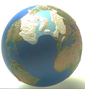
Fig. 24 : LGM ou Last Glacial Maximum, c’est-à-dire la glaciation du ‘Dernier Glaciaire’ dans l’hémisphère nord avec des plateformes de glaces débordant sur l’océan Arctique recouvert de banquise (image CLIMAP). La glace qui recouvrait une grande partie de l’Amérique du Nord, du nord de l’Europe et une partie de l’Asie était épaisse de 3 à 4 km et le niveau marin plus bas de 120 m par rapport à l’Actuel, ce qui permit des passages terrestres, inexistants aujourd’hui suite à la remontée du niveau marin lors de la déglaciation. Cette situation est aussi à l’origine d’une aridification intense (non discutée dans cet article). Les glaces se mirent en place vers 33 ka et leur extension maximale est comprise entre 26,5 ka et 20-19 ka (Clark et al. 2009).


THE SUN UNLEASHES STRONGEST SOLAR FLARE IN 3 YEARS — GSM + MAGNETIC EXCURSION = BYE-BYE EMPIRE MODEL

by Cap Allon, May 30, 2020 in Electroverse


Earth’s magnetosphere continues to weaken (due to an intensifying GSM AND a magnetic excursion/reversal), but at the same time the Sun’s next cycle (25) is showing signs of stirring– this combo spells bad news for all those reliant on the electrical grid, and could deliver a civilization-resetting one-two knockout.

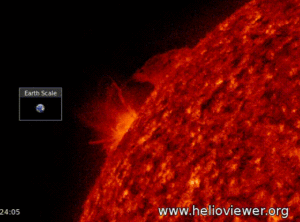
Yesterday (May 29), in the pits of the deepest Solar Minimum of the past 100+ years, the sun unleashed a flurry of spectacular solar flares:

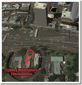
Germany’s DWD National Weather Service Denies Station Siting Problem: “Dubious” All-Time Record Temperature Allowed To Stand

by P. Gosselin, May 26, 2020 in NoTricksZone


Leading German daily Bild here reports on the controversy, which still continues to swirl, over Germany’s all-time record high temperature recorded last year in North Germany near the Dutch border.

Independent meteorologists say the readings needs to be thrown out

Last year on July 25th, the Lingen thermometer reached a whopping 42.6°C, far eclipsing the old German all-time record of 40.3°C. But that recording quickly came under fire by independent weather experts who say the station data were  corrupted by siting issues. The Lingen station is located in a depression in the earth, near a parking lot, and shielded by trees from the wind, thus creating the ideal conditions for trapping heat.

Comparison to nearby stations shows huge anomaly

Last year NTZ reported on the controversial record here noting that surrounding stations did not even come close to record reading in Lingen. What follows is a comparison of the Lingen’s readings to those of 6 nearby stations over the five day period, July 23 – July 27:

New Study: Arctic Waters Were 4°C Warmer Than Today And Nearly Sea-Ice Free Year-Round ~4100 Years Ago

by Brice et al., May 28, 2020 in NoTricksZone


Today, the region north of Svalbard is encrusted with sea ice for all but a few weeks per year and summer sea surface temperatures (SSTs) hover near 0°C.  Scientists (Brice et al., 2020) have determined this same region had sea ice-free conditions last about 10 months per year while SSTs reached 4°C just ~4100 years ago.

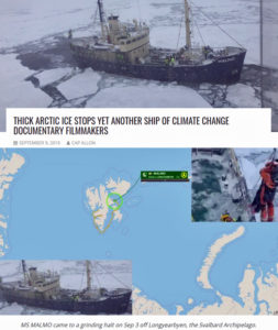
In early September, 2019, Arctic explorers once again needed to be rescued from the “disappearing” sea ice that had captured their ship in central Svalbard. This region is presently free of sea ice for only a few weeks per year (late August).

Image Source: electroverse.net

SOUTH AFRICA: 14 ALL-TIME MONTHLY LOW TEMPERATURE RECORDS FELL YESTERDAY (MAY 28), WITH “WIDESPREAD SNOW” ACCOMPANYING THE FREEZE

by Cap Allon, May 29, 2020 in Electroverse


According to preliminary data from the South African Weather Service, a total of 14 new all-time monthly LOW temperature records were busted yesterday (May 28), versus the 0 for record high.

These record low May temperatures were set ACROSS the southernmost tip of Africa, although the east appears to have been disproportionately hit.

The “II AGR” weather station in Buffelspoort –located NW of Johannesburg– set a new “Lowest Minimum” temperature on Thursday, May 28 of -2C (35.6F) — a reading which comfortably usurped the station’s previous all-time lowest May minimum of 0.9C (33.6F) set back on May 10, 1970.

Secunda –located amidst the coalfields of the Mpumalanga province– was another region to suffer its lowest May temperature on record. The town logged a bone-chilling -3.9C (25F) on Thursday morning, which surpassed the old record of -3.3C (26F) from May 29, 1994.

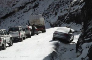
Exceptional snowfall has been accompanying the low temps.

“We’ve got ground-level snow in quite a few places,” said Richard le Sueur of SnowReportSA while on popular SA radio show CapeTalk on May 27.

“The front swept in from the west and has gone right across the country … We’ve had snow on the Western Cape mountains, the Southwestern Cape and through the Southern Cape and into the Eastern Cape … also, in Lesotho and the Northern Cape … So, pretty much widespread snow,” said le Sueur.

“We’re going to see a chilly winter,” he concluded.

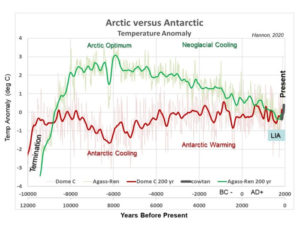
The Yin and Yang of Holocene Polar Regions Andy May / 1 day ago May 27, 2020

by R. Hannon/A. May, May 27, 2020 in WUWT


Introduction

The Arctic and Antarctic regions are different and yet similar in many ways. The Arctic has ocean surrounded by land and the Antarctic is a continent surrounded by water. Both are cold, glaciated and located at Earth’s poles some 11,000 miles apart. While sea ice has been retreating in the Arctic, it has been relatively stable in the Antarctic. This post examines surface temperature trends, solar insolation, and CO2 at the polar Arctic and Antarctic regions during the Holocene interglacial period.


Continuer la lecture de The Yin and Yang of Holocene Polar Regions Andy May / 1 day ago May 27, 2020

Pacific Island states will not longer play the patsies for the climate alarmists

by P. Homewood, May 27, 2020 in NotaLotofpeopleKnowThat


The science is settled. The time for debate is over. It’s actually better than we thought. The Pacific islands are not sinking under rising sea levels, in fact, the peer-reviewed science shows the exact opposite, the majority of low lying islands are either stable or increasing in size — something even ABC FactCheck was forced to concede.

Nevertheless, this has not stopped climate alarmists led by the Portuguese socialist and UN General Secretary Guterres from denying the peer-reviewed science and exploiting Pacific Island nations, by using them as patsies to peddle fear and misinformation with discredited claims of ”sinking islands”.

And so far, the Pacific islanders have been happy to play along; perhaps driven by a cargo-cult mentality, believing if they utter the magic words ”climate change” and pose for the international media forlornly staring out over the sea, that they might be rewarded with cash handouts from the UN Green Global Climate fund.

But that was all before the Wuhan Flu.

Solar wind driven particle precipitation affects winter climate in polar regions

by University of Oulu, March 18, 2020


Changes in space climate driven by long-term changes in solar activity have a significant impact on Earth’s atmosphere and climate. Understanding the complex system requires cooperation between space physics and climate science.


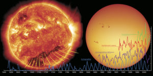
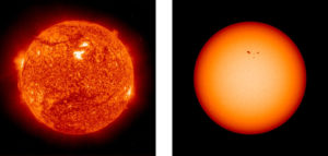
On the right, a picture of the Sun taken at the wavelength of visible light, i.e. like a regular camera at very short shutter speed, visible sunspot groups. The time series in the image illustrate a few long series of data used in space air research.
On green: approximately 40 years of direct satellite measurements, a combination of energetic electrons coming into the Earth’s atmosphere.
In red: from geomagnetic measurements reconstructed estimate of the speed of the solar wind in the last hundred years.
With purple: the longest unified time series for geomagnetic activity (the so-called AA index), starting from 1868 and continuing to the present day.
In blue: 400 year series of sunspots. This set of data is the longest indicator of solar activity based on direct measurements.


Michael Moore film Planet of the Humans removed from YouTube

by P. Homewood, May 27, 2020 in NotaLotofPeopleKnowThat


YouTube has taken down the controversial Michael Moore-produced documentary, Planet of the Humans in response to a copyright infringement claim by a British environmental photographer.

The movie, which has been condemned as inaccurate and misleading by climate scientists and activists, allegedly includes a clip used without the permission of the owner Toby Smith, who does not approve of the context in which his material is being used.

In response, the filmmakers denied violating fair usage rules and accused their critics of politically motivated censorship.

Smith filed the complaint to YouTube on 23 May after discovering Planet of the Humans used several seconds of footage from his Rare Earthenware project detailing the journey of rare earth minerals from Inner Mongolia.

Smith, who has previously worked on energy and environmental issues, said he did not want his work associated with something he disagreed with. “I went directly to YouTube rather than approaching the filmmakers because I wasn’t interested in negotiation. I don’t support the documentary, I don’t agree with its message and I don’t like the misleading use of facts in its narrative.”

Planet of the Humans director Jeff Gibbs said he was working with YouTube to resolve the issue and have the film back up as soon as possible.

https://www.msn.com/en-gb/entertainment/movies/michael-moore-film-planet-of-the-humans-removed-from-youtube/ar-BB14zOSN

MAN-MADE GLOBAL WARMING DESTROYED IN 500 WORDS, BY GEOLOGIST DR ROGER HIGGS

by Cap Allon, May 27, 2020 in Electroverse


INTERGOVERNMENTAL PANEL ON CLIMATE CHANGE IPCC) THREE PILLARS OF MAN-MADE GLOBAL WARMING: COLLAPSED — by Dr Roger Higgs (DPhil Oxford, geology, 1982-86), Geoclastica LtdTechnical Note 2020-7, 25th May 2020, amended 26-5-2020 on ResearchGate.

The IPCC says ongoing warming is due to man’s CO2 emissions, hence ‘Anthropogenic Global Warming’ (AGW). However, the 3 pillars on which they base this claim are unscientific and quickly disproved.

Continuer la lecture de MAN-MADE GLOBAL WARMING DESTROYED IN 500 WORDS, BY GEOLOGIST DR ROGER HIGGS

Tiny plankton drive processes in the ocean that capture twice as much carbon as scientists though

by K. Buesseler, May 2020 in TheConversion


The big idea

The ocean plays a major role in the global carbon cycle. The driving force comes from tiny plankton that produce organic carbon through photosynthesis, like plants on land.

When plankton die or are consumed, a set of processes known as the biological carbon pump carries sinking particles of carbon from the surface to the deep ocean in a process known as marine snowfall. Naturalist and writer Rachel Carson called it the “most stupendous snowfall on Earth.”

Some of this carbon is consumed by sea life, and a portion is chemically broken down. Much of it is carried to deep waters, where it can remain for hundreds to thousands of years. If the deep oceans didn’t store so much carbon, the Earth would be even warmer than it is today.

What still isn’t known

Our study reveals that scientists need to use using a more systematic approach to defining the ocean’s vertical boundaries for organic carbon production and loss. This finding is timely, because the international oceanographic community is calling for more and better studies of the biological carbon pump and the ocean twilight zone.

The twilight zone could be profoundly affected if nations seek to develop new midwater fisheries, mine the seafloor for minerals or use it as a dumping ground for waste. Scientists are forming a collaborative effort called the Joint Exploration of the Twilight Zone Ocean Network, or JETZON, to set research priorities, promote new technologies and better coordinate twilight zone studies.

To compare these studies, researchers need a common set of metrics. For the biological carbon pump, we need to better understand how big this flow of carbon is, and how efficiently it is transported into deeper water for long-term storage. These processes will affect how Earth responds to rising greenhouse gas emissions and the warming they cause.

Study: Ancient ocean oxygen levels associated with changing atmospheric carbon dioxide


by Texas A&M University, May 24, 2020 in WUWT


A Texas A&M-led study analyzed ocean floor sediment cores to provide new insights into the relationship between deep ocean oxygenation and atmospheric carbon dioxide levels in the 50,000 years before the last ice age

IMAGE: Deep ocean floor sediment cores hold chemical clues to Earth’s past. view more  Credit: Texas A&M University

Why do carbon dioxide levels in the atmosphere wax and wane in conjunction with the warm and cold periods of Earth’s past? Scientists have been trying to answer this question for many years, and thanks to chemical clues left in sediment cores extracted from deep in the ocean floor, they are starting to put together the pieces of that puzzle.

Recent research suggests that there was enhanced storage of respired carbon in the deep ocean when levels of atmospheric carbon dioxide concentrations were lower than today’s levels. But new research led by a Texas A&M University scientist has reached back even further, for the first time revealing insights into atmospheric carbon dioxide levels in the 50,000 years before the last ice age.

Reefs’ Neon Colors A Defense Against Coral Bleaching

by B. Bruno,  May 22, 2020 in ClimateChangeDispatch


Some coral reefs are adapting to warming ocean temperatures by making their own sunscreen in the form of bright neon colors — a strategy that invites coral animals to return to reefs and is seen as a critical adaptation to maintain healthy coral reefs around the world.

In a study published Thursday in the journal Current Biology, researchers at the University of Southampton detail a series of controlled laboratory experiments they conducted at their coral aquarium facility.

In the experiments, “colorful” coral bleaching events cause coral to produce a layer of vibrant sunscreen which encourages the coral animals vital to a mutually beneficial “symbiosis” relationship to return to coral habitats they abandon due to the effects of warming oceans.

The colorful adaptation could prove vital for overcoming the fatal coral bleaching incidents that have threatened coral reefs worldwide.

But the colorful coral bleaching – rather than the white skeleton exposure of common coral bleaching events – is believed to take place due to mild ocean warming or disturbances in their nutrient environment, rather than extreme events.

Colorful bleaching occurred between this past March and April in some areas of the Great Barrier Reef, suggesting some patches of the world’s largest reef system may have better recovery prospects than others.

The Global CO2 lockdown problem

by Sherrington G., May 22, 2020 in WUWT


The global problem.

In response to the threat of a global viral epidemic, countries announced lockdowns at various times near 25th March 2020. https://en.wikipedia.org/wiki/COVID-19_pandemic_lockdowns

This caused a reduction of industrial activity and hence a lower rate of emission of anthropogenic carbon dioxide to the atmosphere. An example of reduction from aircraft is given at https://en.wikipedia.org/wiki/Impact_of_the_COVID-19_pandemic_on_aviation

Numerous sources asked if the reduction in CO2 emission could be detected in analysis of air for CO2 content, which had been done for decades. Early questions and speculative answers came from many sources including –

https://www.esrl.noaa.gov/gmd/ccgg/covid2.html

https://www.aljazeera.com/news/2020/03/coronavirus-lockdown-leads-improved-air-quality-200322094404592.html

By late May 2020, the emerging consensus was that the reduction would be too small to show at the main measuring stations such as Mauna Loa, Hawaii.

Giant tectonic plate under Indian Ocean is breaking in two

by Geggel L., May 21, 2020 in LiveScience


The giant tectonic plate under the Indian Ocean is going through a rocky breakup … with itself.

In a short time (geologically speaking) this plate will split in two, a new study finds.

To humans, however, this breakup will take an eternity. The plate, known as the India-Australia-Capricorn tectonic plate, is splitting at a snail’s pace — about 0.06 inches (1.7 millimeters) a year. Put another way, in 1 million years, the plate’s two pieces will be about 1 mile (1.7 kilometers) farther apart than they are now.

“It’s not a structure that is moving fast, but it’s still significant compared to other planet boundaries,” said study co-researcher Aurélie Coudurier-Curveur, a senior research fellow of marine geosciences at the Institute of Earth Physics of Paris.

Related: In photos: Ocean hidden beneath Earth’s surface

For instance, the Dead Sea Fault in the Middle East is moving at about double that rate, or 0.2 inches (0.4 centimeters) a year, while the San Andreas Fault in California is moving about 10 times faster, at about 0.7 inches (1.8 cm) a year.

The plate is splitting so slowly and it’s so far underwater, researchers almost missed what they’re calling the “nascent plate boundary.” But two enormous clues — that is, two strong earthquakes originating in a strange spot in the Indian Ocean — suggested that Earth-changing forces were afoot.

On April 11, 2012, a magnitude-8.6 and magnitude-8.2 earthquake hit beneath the Indian Ocean, near Indonesia. The earthquakes didn’t happen along a subduction zone, where one tectonic plate slides under another. Instead, these quakes originated in a weird place for earthquakes to happen — in the middle of the plate.

UPDATE 1-China to bolster energy reserve capacity, support unconventional gas exploration

by Xu M. & Daly T., May 22, 2020 in Reuters


BEIJING, May 22 (Reuters) – China said on Friday it will bolster the capacity of the country’s energy reserves and offer lower gas and electricity charges to key industries, as it looks to ensure energy supply and offset the impact of the coronavirus pandemic.

In energy announcements on the first day of the parliament, known as the National People’s Congress (NPC), authorities also pledged to boost the country’s oil and gas network and continue to support exploration for unconventional gas reserves.

The National Development and Reform Commission (NDRC) said in a statement it would push forward construction of crude oil reserves.

The coronavirus pandemic has led to a slump in demand for crude oil, with insufficient storage capacity worldwide.

The NDRC said it would also press ahead with competitive trading of mining rights for oil- and gas-bearing zones, aiming to attract more market players into oil and gas exploration and production.

The country will also accelerate construction of oil and gas network and encourage the opening up of pipeline facilities to all eligible users, said the state planner.

China set up its long-awaited national oil and gas pipeline company in December aiming at providing fair market access to infrastructure and boost investment in oil and gas production.

Arctique géologique 1/2

by Préat A. & Van Vliet-Lanoë B., 22 mai 2020 in ScienceClimatEnergie


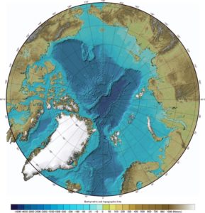
A la grande différence de l’Antarctique, l’Arctique est un océan entouré de plateaux continentaux (Fig. 2). L’océan ou bassin arctique est actuellement constitué par un double bassin, séparé une crête très importante, la ride Lomonosov : le sous-bassin canadien à croûte continentale amincie (3 600 m)  et le sous-bassin eurasiatique à croûte océanique mince, de loin le plus profond (5000 m entre la crête Lomonosov et la ride océanique active de Gakkel). Il est entouré comme le long de l’Atlantique Nord par une plateforme continentale ennoyée, constituée de croûte continentale.  Le bassin arctique  d’abord marin et connecté au Proto-Atlantique au début du Jurassique (voir plus loin), est isolé depuis le Jurassique moyen et essentiellement de nature lacustre, modifiant le régime thermique océanique, amenant un contexte voisin du Glaciaire au Crétacé inférieur (au Valanginien in Dromart et al. 2003 ; Korte et al. 2015 ; Piskarev et al. 2018). Il ne se ré-ouvrira sur le bassin atlantique qu’à partir de l’Eocène, via l’ouverture du détroit de Fram. D’autre part le pôle  magnétique terrestre (Nord) est resté sur le bassin arctique depuis le début du Jurassique, donc en position de déficit énergétique lié à l’obliquité de l’orbite terrestre.

Fig. 2  Image Gebco Arctique : L’océan ou bassin arctique est actuellement constitué par un double bassin, séparé une crête très importante, la ride Lomonossov (voir texte).

Supercomputer model simulations reveal cause of Neanderthal extinction

by Insitute for basic science, May 20, 2020 in PhsyOrg


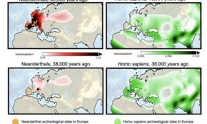
Climate scientists from the IBS Center for Climate Physics discover that, contrary to previously held beliefs, Neanderthal extinction was neither caused by abrupt glacial climate shifts, nor by interbreeding with Homo sapiens. According to new supercomputer model simulations, only competition between Neanderthals and Homo sapiens can explain the rapid demise of Neanderthals around 43 to 38 thousand years ago.

Neanderthals lived in Eurasia for at least 300,000 years. Then, around 43 to 38 thousand years ago they quickly disappeared off the face of the earth, leaving only weak genetic traces in present-day Homo sapiens populations. It is well established that their extinction coincided with a period of rapidly fluctuating climatic conditions, as well as with the arrival of Homo sapiens in Europe. However, determining which of these factors was the dominant cause, has remained one of the biggest challenges of evolutionary anthropology.


Figure 1: Computer simulations of population density of Neanderthals (left) and Homo sapiens (right)

What You Should Know About Ice Ages & Climate Change

by D.W. Euring, May 20, 2020 in PrincipiaScientificInternational


It became apparent from investigation of the Variability of the Gravitational Constant that Jupiter’s orbit is affecting the Sun’s surface temperature and driving the Sunspot Cycle which appear to be triggered at its Aphelion and suppressed at Perihelion.

Saturn has even greater eccentricity than Jupiter and it is noted that it was at Perihelion at the end of 1972 which seems to account for the Low Solar Maximum at that time and a particular dip after the main peak. So, whilst cycle periods are not influenced by Saturn, it does impact on their magnitude, and it seems likely that it will have augmented in 1957-58 as well as 1990.

Tendencies, variability and persistence of sea surface temperature anomalies

by Bulgin et al., May 14, 2020 in Nature OPEN ACCESS


Abstract

Quantifying global trends and variability in sea surface temperature (SST) is of fundamental importance to understanding changes in the Earth’s climate. One approach to observing SST is via remote sensing. Here we use a 37-year gap-filled, daily-mean analysis of satellite SSTs to quantify SST trends, variability and persistence between 1981–2018. The global mean warming trend is 0.09 K per decade globally, with 95% of local trends being between −0.1 K and + 0.35 K. Excluding perennial sea-ice regions, the mean warming trend is 0.11 K per decade. After removing the long-term trend we calculate the SST power spectra over different time periods. The maximum variance in the SST power spectra in the equatorial Pacific is 1.9 K2 on 1–5 year timescales, dominated by ENSO processes. In western boundary currents characterised by an intense mesoscale activity, SST power on sub-annual timescales dominates, with a maximum variance of 4.9 K2. Persistence timescales tend to be shorter in the summer hemisphere due to the shallower mixed layer. The median short-term persistence length is 11–14 days, found over 71–79% of the global ocean area, with seasonal variations. The mean global correlation between monthly SST anomalies with a three-month time-lag is 0.35, with statistically significant correlations over 54.0% of the global oceans, and notably in the northern and equatorial Pacific, and the sub-polar gyre south of Greenland. At six months, the mean global SST anomaly correlation falls to 0.18. The satellite data record enables the detailed characterisation of temporal changes in SST over almost four decades.

 …

WORLDWIDE VOLCANIC UPTICK — MULTIPLE ERUPTIONS TO 45,000+ FT (13.7+ KM) — DIRECT COOLING EFFECT

by Cap Allon, May 1, 2020 in Electroverse


These past few days have seen a violent worldwide volcanic uptick, sending us all further signs that the next Grand Solar Minimum is dawning.

HIMAWARI-8 (a Japanese weather satellite) recorded two HIGH-LEVEL eruptions on May 16, both occurring in Indonesia.

The first took place at Ibu –a relatively new volcano with only 3 notable eruptions; in 1911, 1998, and 2008– and was confirmed by the Volcanic Ash Advisory Center (VAAC) Darwin which warned of an ash plume rising to an estimated 45,000 ft (13.7 km).

The second high-level eruption took place just a few hours later at Semeru –a very active volcano with an eruptive history peppered with VEI 2s and 3s; the first coming in 1818, the most recent in 2014– and as with Ibu’s, Semeru’s eruption was picked up by both HIMAWARI-8 and the VAAC Darwin, with the latter confirming the generation of “a dark ash plume which reached an altitude of 46,000 ft (14 km).”

In addition, and as recently reported by VolcanoDiscovery.com, active lava flows remain active on the Semeru’s southeast flank, currently about 4,921 ft (1.5 km) long (as of the morning of May 18).

https://principia-scientific.org/do-cosmic-rays-trigger-earthquakes-volcanic-eruptions/https://www.researchgate.net/publication/234022172_Explosive_volcanic_eruptions_triggered_by_cosmic_rays_Volcano_as_a_bubble_chamber

Earth’s Mean Temperature Falling, Planetary Alignment Suspected As Driver Of The 11-Year Solar Cycle

by F. Vahrenholt, May 9, 2020 in NoTricksZone


The global mean temperature in April 2020 was again significantly lower than in February and March, at 0.38°C above the average from 1981 to 2010. The average temperature increase on the globe from 1981 to February 2020 was 0.14°C per decade. The further development promises to be interesting, especially since a number of research institutes expect a higher probability of a cooling La Nina in the Pacific towards the end of the year. March’s solar activity was very low with a sunspot number of 1.5.  Activity in April rose slightly to 5.4. The first sunspots of the new cycle are showing.

What causes the sun to have an 11-year cycle?

Since the Dessau pharmacist Heinrich Samuel Schwabe discovered in 1843 that the sunspots of the sun increase and decrease in an 11-year cycle, science has been puzzling over the reason why this cycle lasts 11 years and why the solar magnetic field also changes its polarity in this rhythm: the north pole becomes the south pole and vice versa.

In July last year, scientists at the Helmholtz Centre in Dresden Rossendorf made a little-noticed but exciting discovery. Every 11.07 years, the planets Venus, Earth and Jupiter are aligned quite precisely. At this point in time, their gravitational force acts jointly in one direction on the Sun.

Image: NASA Earth Observatory. Public Domain

Why the Current Economic Slowdown Won’t Show Up in the Atmospheric CO2 Record

by Rotter, from Spencer, May 15, 2020 in WUWT


May 15th, 2020 by Roy W. Spencer, Ph. D.

[UPDATE: MISSING IMAGES INSERTED]

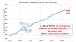
Summary: Atmospheric levels of carbon dioxide (CO2) continue to increase with no sign of the global economic slowdown in response to the spread of COVID-19. This is because the estimated reductions in CO2 emissions (around -11% globally during 2020) is too small a reduction to be noticed against a background of large natural variability. The reduction in economic activity would have to be 4 times larger than 11% to halt the rise in atmospheric CO2.

Changes in the atmospheric reservoir of CO2 occur when there is an imbalance between surface sources and sinks of CO2. While the global land and ocean areas emit approximately 30 times as much CO2 into the atmosphere as humans produce from burning of fossil fuels, they also absorb about an equal amount of CO2. This is the global carbon cycle, driven mostly by biological activity.

Fig. 2. Monthly CO2 data since 2015 from Mauna Loa, HI after the average seasonal cycle is statistically removed.

ADDENDUM: How much of a decrease in CO2 emissions would be required to stop the atmospheric rise in CO2?


Continuer la lecture de Why the Current Economic Slowdown Won’t Show Up in the Atmospheric CO2 Record