by Géoclimat, 26 août 2020
L’Amérique du Sud a connu une vague de froid particulièrement remarquable par son intensité et son étendue géographique du 19 au 23 août 2020, c’est-à-dire durant la seconde partie de l’hiver météorologique austral qui s’achève à la fin de ce mois.
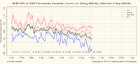
Cet épisode froid est intervenu alors que l’hémisphère sud enregistre un déficit thermique significatif depuis le début du mois d’août et une tendance à la baisse de la température moyenne sur les 5 derniers mois. Dans ce contexte climatique, plusieurs coups de froid se sont produits dans l’hémisphère sud depuis le début de l’hiver, notamment en Australie au début du mois d’août avec un record absolu de froid enregistré par l’État insulaire de Tasmanie le 7 août (-14,2°C à Liawenee) et des chutes de neige abondantes au centre de l’île le 5 août (les plus importantes à Launceston depuis la tempête de neige du 31 juillet 1921), en Afrique australe à plusieurs reprises durant l’hiver, dans le sud-ouest de l’océan Indien en août, dans plusieurs archipels de l’Océanie (en Polynésie française en juin et début juillet, en Nouvelle-Calédonie à la mi-juillet), ou encore dans le sud de l’Argentine dès la fin du mois de juin avec -20,0°C le 27 juin à l’aéroport de Perito Moreno en Patagonie qui enregistre à cette occasion sa plus basse température pour un mois d’août depuis 1961 (précédent record : -18,2°C le 21 juin 2002), puis durant la première quinzaine de juillet avec des températures anormalement basses en Patagonie qui enregistre son 4e mois de juillet le plus froid depuis 1961 et d’abondantes chutes de neige à basse altitude en Patagonie et sur les reliefs andins (en particulier dans la province de Mendoza où il n’avait pas autant neigé depuis plus de 15 ans et jamais autant sur une période de 10 jours).
Une vague de froid plus intense et de plus grande ampleur a touché l’Amérique du Sud à partir du 19 août 2020, avec des températures particulièrement basses en Argentine les 20 et 21 août : plusieurs stations dans le centre et le nord du pays ont enregistré un record mensuel de froid, comme Villa Reynolds (-13,1°C le 20), Santa Rosa de Conlara (-12,0°C le 20), Río Cuarto (-5,0°C le 20), Córdoba (-6,5°C le 21), Presidencia Roque Sáenz Peña (-6,1°C le 21) et Corrientes (-1,7°C le 21).